![](/images/other/stat-length.png)
![Trail On foot Teplice - [M] 9322 Modrý vycházkový okruh - Photo](https://media.geolcdn.com/t/1900/400/ext.pjpeg?maxdim=2&url=https%3A%2F%2Fstatic1.geolcdn.com%2Fsiteimages%2Fupload%2Ffiles%2F1545311037marcheuse_200dpi.jpg)
[M] 9322 Modrý vycházkový okruh
SityTrail - itinéraires balisés pédestres
Tous les sentiers balisés d’Europe GUIDE+
![Length](/images/other/stat-length.png)
Length
7.8 km
![Max alt](https://static1.geolcdn.com/siteimages/upload/files/1508320355ic_sort_altitude_max_24dp.png)
Max alt
381 m
![Uphill gradient](https://static1.geolcdn.com/siteimages/upload/files/1508320355ic_sort_den_pos_24dp.png)
Uphill gradient
172 m
![Km-Effort](/images/other/stat-length.png)
Km-Effort
10.1 km
![Min alt](https://static1.geolcdn.com/siteimages/upload/files/1508320355ic_sort_altitude_min_24dp.png)
Min alt
232 m
![Downhill gradient](https://static1.geolcdn.com/siteimages/upload/files/1508320355ic_sort_den_neg_24dp.png)
Downhill gradient
175 m
![Boucle](https://static1.geolcdn.com/siteimages/upload/files/16400158638029165_repeat_loop_refresh_sync_direction_icon.png)
Boucle
Yes
Signpost
Creation date :
2025-02-07 05:15:22.737
Updated on :
2025-02-07 05:15:22.737
![On foot](https://static1.geolcdn.com/sitytour/trail-icons/100.png)
2h18
Difficulty : Easy
![Scan this QR Code to open this trail in the SityTrail application](https://capi.geolives.com/qq0zvz2zws4bq2lad0pu/sitytour/trails/4344664/qr.png?size=200)
FREE GPS app for hiking
About
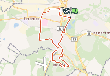
Trail On foot of 7.8 km to be discovered at Northwest, Ústecký kraj, Teplice. This trail is proposed by SityTrail - itinéraires balisés pédestres.
Description
Trail created by cz:KČT.
Zámecké nám. - Zámecká zahr. - Řetenice - Areál Perla - Na Stínadlech - Zámecké nám.
Positioning
Country:
Czech Republic
Region :
Northwest
Department/Province :
Ústecký kraj
Municipality :
Teplice
Location:
Unknown
Start:(Dec)
Start:(UTM)
416921 ; 5610170 (33U) N.
Comments
Trails nearby
![Trail On foot Teplice - [Z] 3987 Okruh kolem Doubravky - Photo](https://media.geolcdn.com/t/375/260/3cf74112-642d-4ebf-a1e3-d97f4e384318.jpeg&format=jpg&maxdim=2)
![On foot On foot](https://static1.geolcdn.com/sitytour/trail-icons/100.png)
[Z] 3987 Okruh kolem Doubravky
On foot
Easy
Teplice,
Northwest,
Ústecký kraj,
Czech Republic
![](/images/other/stat-length.png)
5.1 km | 7 km-effort
1h 36min
![](https://static1.geolcdn.com/siteimages/upload/files/16400158638029165_repeat_loop_refresh_sync_direction_icon.png)
Yes
![Trail On foot Teplice - [Č] 9302 Červený vycházkový okruh - Photo](https://media.geolcdn.com/t/375/260/ext.jpg?maxdim=2&url=https%3A%2F%2Fstatic1.geolcdn.com%2Fsiteimages%2Fupload%2Ffiles%2F1545311037marcheuse_200dpi.jpg)
![On foot On foot](https://static1.geolcdn.com/sitytour/trail-icons/100.png)
[Č] 9302 Červený vycházkový okruh
On foot
Easy
Teplice,
Northwest,
Ústecký kraj,
Czech Republic
![](/images/other/stat-length.png)
4.1 km | 5 km-effort
1h 8min
![](https://static1.geolcdn.com/siteimages/upload/files/16400158638029165_repeat_loop_refresh_sync_direction_icon.png)
Yes