![](/images/other/stat-length.png)
![Trail On foot Nedvědice - Po naučných stezkách na hrad Pernštejn I. etapa - Photo](https://media.geolcdn.com/t/1900/400/f0f9e1db-cb23-468e-bac3-af798b271997.jpeg&format=pjpeg&maxdim=2)
Po naučných stezkách na hrad Pernštejn I. etapa
SityTrail - itinéraires balisés pédestres
Tous les sentiers balisés d’Europe GUIDE+
![Length](/images/other/stat-length.png)
Length
3.3 km
![Max alt](https://static1.geolcdn.com/siteimages/upload/files/1508320355ic_sort_altitude_max_24dp.png)
Max alt
420 m
![Uphill gradient](https://static1.geolcdn.com/siteimages/upload/files/1508320355ic_sort_den_pos_24dp.png)
Uphill gradient
142 m
![Km-Effort](/images/other/stat-length.png)
Km-Effort
5 km
![Min alt](https://static1.geolcdn.com/siteimages/upload/files/1508320355ic_sort_altitude_min_24dp.png)
Min alt
338 m
![Downhill gradient](https://static1.geolcdn.com/siteimages/upload/files/1508320355ic_sort_den_neg_24dp.png)
Downhill gradient
98 m
![Boucle](https://static1.geolcdn.com/siteimages/upload/files/16400158638029165_repeat_loop_refresh_sync_direction_icon.png)
Boucle
No
Signpost
Creation date :
2025-02-07 05:03:59.623
Updated on :
2025-02-07 05:03:59.623
![On foot](https://static1.geolcdn.com/sitytour/trail-icons/100.png)
1h08
Difficulty : Easy
![Scan this QR Code to open this trail in the SityTrail application](https://capi.geolives.com/qq0zvz2zws4bq2lad0pu/sitytour/trails/4344648/qr.png?size=200)
FREE GPS app for hiking
About
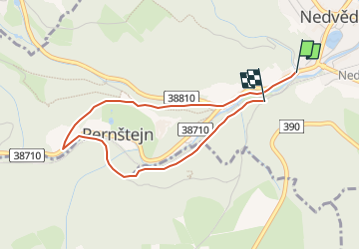
Trail On foot of 3.3 km to be discovered at Southeast, Jihomoravský kraj, Nedvědice. This trail is proposed by SityTrail - itinéraires balisés pédestres.
Description
Trail created by městys Nedvědice.
Website: http://www.pernstejnsko.cz/naucne-stezky/
Positioning
Country:
Czech Republic
Region :
Southeast
Department/Province :
Jihomoravský kraj
Municipality :
Nedvědice
Location:
Unknown
Start:(Dec)
Start:(UTM)
596384 ; 5478766 (33U) N.
Comments
Trails nearby
![Trail On foot Kunštát - [Ž] Svitávka - Rudka - Photo](https://media.geolcdn.com/t/375/260/94d66308-b810-471c-9787-b29d9f662f14.jpeg&format=jpg&maxdim=2)
![On foot On foot](https://static1.geolcdn.com/sitytour/trail-icons/100.png)
[Ž] Svitávka - Rudka
On foot
Easy
Kunštát,
Southeast,
Jihomoravský kraj,
Czech Republic
![](/images/other/stat-length.png)
10.6 km | 12.6 km-effort
2h 52min
![](https://static1.geolcdn.com/siteimages/upload/files/16400158638029165_repeat_loop_refresh_sync_direction_icon.png)
No
![Trail On foot Lomnice - naučná stezka Járy Cimrmana - Photo](https://media.geolcdn.com/t/375/260/10d7421d-cfd1-4327-8e81-fb06f3955da3.jpeg&format=jpg&maxdim=2)
![On foot On foot](https://static1.geolcdn.com/sitytour/trail-icons/100.png)
naučná stezka Járy Cimrmana
On foot
Easy
Lomnice,
Southeast,
Jihomoravský kraj,
Czech Republic
![](/images/other/stat-length.png)
4.9 km | 7.7 km-effort
1h 45min
![](https://static1.geolcdn.com/siteimages/upload/files/16400158638029165_repeat_loop_refresh_sync_direction_icon.png)
No
![Trail On foot Předklášteří - Naučná stezka Květnice - Photo](https://media.geolcdn.com/t/375/260/2c18e53a-ea8e-4eb9-9d60-e34adc5101e9.jpeg&format=jpg&maxdim=2)
![On foot On foot](https://static1.geolcdn.com/sitytour/trail-icons/100.png)
Naučná stezka Květnice
On foot
Easy
Předklášteří,
Southeast,
Jihomoravský kraj,
Czech Republic
![](/images/other/stat-length.png)
6.2 km | 9.2 km-effort
2h 5min
![](https://static1.geolcdn.com/siteimages/upload/files/16400158638029165_repeat_loop_refresh_sync_direction_icon.png)
Yes
![Trail On foot Koroužné - Svratecká vodohospodářská naučná stezka - Photo](https://media.geolcdn.com/t/375/260/26f5476c-43fa-4ca2-9ff8-3ede3473eb76.jpeg&format=jpg&maxdim=2)
![On foot On foot](https://static1.geolcdn.com/sitytour/trail-icons/100.png)
Svratecká vodohospodářská naučná stezka
On foot
Medium
Koroužné,
Southeast,
Kraj Vysočina,
Czech Republic
![](/images/other/stat-length.png)
16.4 km | 21 km-effort
4h 47min
![](https://static1.geolcdn.com/siteimages/upload/files/16400158638029165_repeat_loop_refresh_sync_direction_icon.png)
No
![Trail On foot Vranov - Krajem říčky Ponávky (pěší) - Photo](https://media.geolcdn.com/t/375/260/d4892074-ca0b-450c-9484-555e1ddcdd27.jpeg&format=jpg&maxdim=2)
![On foot On foot](https://static1.geolcdn.com/sitytour/trail-icons/100.png)
Krajem říčky Ponávky (pěší)
On foot
Easy
Vranov,
Southeast,
Jihomoravský kraj,
Czech Republic
![](/images/other/stat-length.png)
5 km | 7.2 km-effort
1h 37min
![](https://static1.geolcdn.com/siteimages/upload/files/16400158638029165_repeat_loop_refresh_sync_direction_icon.png)
No
![Trail On foot Nové Město na Moravě - [M] Ochoza - okruh, local - Photo](https://media.geolcdn.com/t/375/260/dce1f716-3160-4704-a566-a47335ab040b.jpeg&format=jpg&maxdim=2)
![On foot On foot](https://static1.geolcdn.com/sitytour/trail-icons/100.png)
[M] Ochoza - okruh, local
On foot
Easy
Nové Město na Moravě,
Southeast,
Kraj Vysočina,
Czech Republic
![](/images/other/stat-length.png)
10.5 km | 15 km-effort
3h 25min
![](https://static1.geolcdn.com/siteimages/upload/files/16400158638029165_repeat_loop_refresh_sync_direction_icon.png)
Yes
![Trail On foot Věcov - Naučná stezka Metodka - Photo](https://media.geolcdn.com/t/375/260/992490b9-69b5-47f8-9951-50652ed6ca6a.jpeg&format=jpg&maxdim=2)
![On foot On foot](https://static1.geolcdn.com/sitytour/trail-icons/100.png)
Naučná stezka Metodka
On foot
Easy
Věcov,
Southeast,
Kraj Vysočina,
Czech Republic
![](/images/other/stat-length.png)
3.7 km | 4.4 km-effort
1h 0min
![](https://static1.geolcdn.com/siteimages/upload/files/16400158638029165_repeat_loop_refresh_sync_direction_icon.png)
Yes
![Trail On foot Bobrová - NS Okolím Bobrové (červená) - Photo](https://media.geolcdn.com/t/375/260/0e24b115-55b2-4400-bed8-93552e7e2f99.jpeg&format=jpg&maxdim=2)
![On foot On foot](https://static1.geolcdn.com/sitytour/trail-icons/100.png)
NS Okolím Bobrové (červená)
On foot
Easy
Bobrová,
Southeast,
Kraj Vysočina,
Czech Republic
![](/images/other/stat-length.png)
6.1 km | 8.3 km-effort
1h 52min
![](https://static1.geolcdn.com/siteimages/upload/files/16400158638029165_repeat_loop_refresh_sync_direction_icon.png)
Yes
![Trail On foot Tišnov - Po starých názvech Jamného - Photo](https://media.geolcdn.com/t/375/260/179411d4-a256-427f-9746-de8ed0aa2d4f.jpeg&format=jpg&maxdim=2)
![On foot On foot](https://static1.geolcdn.com/sitytour/trail-icons/100.png)
Po starých názvech Jamného
On foot
Easy
Tišnov,
Southeast,
Jihomoravský kraj,
Czech Republic
![](/images/other/stat-length.png)
5.4 km | 7.5 km-effort
1h 42min
![](https://static1.geolcdn.com/siteimages/upload/files/16400158638029165_repeat_loop_refresh_sync_direction_icon.png)
Yes