Trail On foot Lipová-lázně - NS Johanna Schrotha - Photo

Tous les sentiers balisés d’Europe GUIDE+

© OpenStreetMap contributors
Length
Length
9 km
Max alt
Max alt
732 m
Uphill gradient
Uphill gradient
260 m
Km-Effort
Km-Effort  
12.3 km
Min alt
Min alt
501 m
Downhill gradient
Downhill gradient
211 m
Boucle
Boucle
No
Signpost
Signpost
Creation date :
2025-02-07 03:43:48.131
Updated on :
2025-02-07 03:43:48.131

(0 Reviews)

On foot
On foot
2h47
Difficulty : Easy

Scan this QR Code to open this trail in the SityTrail application

FREE GPS app for hiking

Logo SityTrail SityTrail

IGN / Geographical institutes

Download SityTrail from the App Store Download SityTrail from Google Play

Logo SityTrail SityTrail World

The world is yours!

Download SityTrail from the App Store Download SityTrail from Google Play Download SityTrail on Huawei AppGallery

About

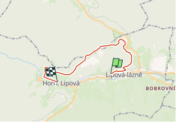
Trail On foot of 9 km to be discovered at Central Moravia, Olomouc Region, Lipová-lázně. This trail is proposed by SityTrail - itinéraires balisés pédestres.

Description

Trail created by cz:KČT.

Elevation profile

Positioning

Country:
Czech Republic
Region :
Central Moravia
Department/Province :
Olomouc Region
Municipality :
Lipová-lázně
Location:
Unknown
Start:(UTM)
651996 ; 5566169 (33U) N.

Trails nearby

Trail On foot Lipová-lázně - [Č] Lázně Lipová - Dolní Lipová - Photo
On foot
GUIDE+

On foot

Easy
Lipová-lázně, Central Moravia, Olomouc Region, Czech Republic
3.8 km | 4.5 km-effort
1h 0min
No
Trail On foot Lipová-lázně - [Z] Ramzová - Obří skály - Photo
On foot
GUIDE+

On foot

Easy
Lipová-lázně, Central Moravia, Olomouc Region, Czech Republic
5 km | 7.2 km-effort
1h 38min
No
Trail On foot Vápenná - [M] Vápenná - Pod Sokolím - Photo
On foot
GUIDE+

On foot

Easy
Vápenná, Central Moravia, Olomouc Region, Czech Republic
6 km | 7.5 km-effort
1h 42min
No


Close
My subscriptions