


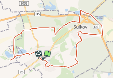

17.7 km | 23 km-effort
![Trail On foot Líně - [Č] Líňská okružní trasa - Photo](https://media.geolcdn.com/t/1900/400/cbeb49cd-7fbd-4b7b-bd64-d76bac41e164.jpeg&format=pjpeg&maxdim=2)

Tous les sentiers balisés d’Europe GUIDE+


FREE GPS app for hiking
 SityTrail
IGN / Geographical institutes
SityTrail World
The world is yours!
Trail On foot of 12.1 km to be discovered at Southwest, Plzeňský kraj, Líně. This trail is proposed by SityTrail - itinéraires balisés pédestres.
![Trail On foot Líně - [Č] Líňská okružní trasa - Photo 1](https://media.geolcdn.com/t/2048/auto/b0807846-04af-4a31-9549-3069a92e454f.jpeg&format=jpg&maxdim=0 "Trail On foot Líně - [Č] Líňská okružní trasa - Photo 1")
![Trail On foot Líně - [Č] Líňská okružní trasa - Photo 2](https://media.geolcdn.com/t/2048/auto/677e53dd-31ce-4ab9-891c-82823051c091.jpeg&format=jpg&maxdim=0 "Trail On foot Líně - [Č] Líňská okružní trasa - Photo 2")
![Trail On foot Líně - [Č] Líňská okružní trasa - Photo 3](https://media.geolcdn.com/t/2048/auto/07b35023-2492-4770-a32a-3c71fe1047c2.jpeg&format=jpg&maxdim=0 "Trail On foot Líně - [Č] Líňská okružní trasa - Photo 3")
![Trail On foot Líně - [Č] Líňská okružní trasa - Photo 4](https://media.geolcdn.com/t/2048/auto/af01592a-ab39-4b8c-8895-ffa566d7152e.jpeg&format=jpg&maxdim=0 "Trail On foot Líně - [Č] Líňská okružní trasa - Photo 4")
![Trail On foot Líně - [Č] Líňská okružní trasa - Photo 5](https://media.geolcdn.com/t/2048/auto/7775dffa-8cfb-45f9-80bc-aee911f90e4c.jpeg&format=jpg&maxdim=0 "Trail On foot Líně - [Č] Líňská okružní trasa - Photo 5")
![Trail On foot Líně - [Č] Líňská okružní trasa - Photo 6](https://media.geolcdn.com/t/2048/auto/b2aeb955-c61d-4584-8829-c2b60c0a5957.jpeg&format=jpg&maxdim=0 "Trail On foot Líně - [Č] Líňská okružní trasa - Photo 6")
![Trail On foot Líně - [Č] Líňská okružní trasa - Photo 7](https://media.geolcdn.com/t/2048/auto/e4692a6d-ab87-4602-a658-dd94e288057e.jpeg&format=jpg&maxdim=0 "Trail On foot Líně - [Č] Líňská okružní trasa - Photo 7")
![Trail On foot Líně - [Č] Líňská okružní trasa - Photo 8](https://media.geolcdn.com/t/2048/auto/f181c380-f633-495a-b3c0-c9ebc1a5f2f8.jpeg&format=jpg&maxdim=0 "Trail On foot Líně - [Č] Líňská okružní trasa - Photo 8")
![Trail On foot Líně - [Č] Líňská okružní trasa - Photo 9](https://media.geolcdn.com/t/2048/auto/762003ab-5510-4742-aeed-7032ad99ffe3.jpeg&format=jpg&maxdim=0 "Trail On foot Líně - [Č] Líňská okružní trasa - Photo 9")
![Trail On foot Líně - [Č] Líňská okružní trasa - Photo 10](https://media.geolcdn.com/t/2048/auto/cbeb49cd-7fbd-4b7b-bd64-d76bac41e164.jpeg&format=jpg&maxdim=0 "Trail On foot Líně - [Č] Líňská okružní trasa - Photo 10")
On foot
![Trail On foot Chotěšov - [Z] Chotěšov - Chudenice - Photo](https://media.geolcdn.com/t/375/260/db6e0667-71ef-4d53-8b64-8b347f6d468d.jpeg&format=jpg&maxdim=2)
On foot