


3.2 km | 4.1 km-effort
![Trail On foot Hlubočky - [Ž] Mariánské Údolí - Olomouc hl.n. - Photo](https://media.geolcdn.com/t/1900/400/1f62cd43-3bfa-4839-90b3-12f580a35229.jpeg&format=pjpeg&maxdim=2)

Tous les sentiers balisés d’Europe GUIDE+


FREE GPS app for hiking
 SityTrail
IGN / Geographical institutes
SityTrail World
The world is yours!
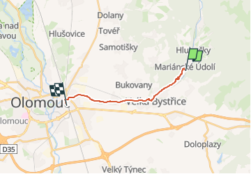
Trail On foot of 11 km to be discovered at Central Moravia, Olomouc Region, Hlubočky. This trail is proposed by SityTrail - itinéraires balisés pédestres.
Trail created by cz:KČT.
![Trail On foot Hlubočky - [Ž] Mariánské Údolí - Olomouc hl.n. - Photo 1](https://media.geolcdn.com/t/2048/auto/f4c4c745-de51-4a99-8db7-38a1ac7ca8a0.jpeg&format=jpg&maxdim=0 "Trail On foot Hlubočky - [Ž] Mariánské Údolí - Olomouc hl.n. - Photo 1")
![Trail On foot Hlubočky - [Ž] Mariánské Údolí - Olomouc hl.n. - Photo 2](https://media.geolcdn.com/t/2048/auto/b1eb5642-830b-4339-804c-69e3a335159e.jpeg&format=jpg&maxdim=0 "Trail On foot Hlubočky - [Ž] Mariánské Údolí - Olomouc hl.n. - Photo 2")
![Trail On foot Hlubočky - [Ž] Mariánské Údolí - Olomouc hl.n. - Photo 3](https://media.geolcdn.com/t/2048/auto/21f60c60-e62b-4275-80bd-d812fff161b2.jpeg&format=jpg&maxdim=0 "Trail On foot Hlubočky - [Ž] Mariánské Údolí - Olomouc hl.n. - Photo 3")
![Trail On foot Hlubočky - [Ž] Mariánské Údolí - Olomouc hl.n. - Photo 4](https://media.geolcdn.com/t/2048/auto/6fc4fa98-b5d7-4c29-a65a-68b9012e0d83.jpeg&format=jpg&maxdim=0 "Trail On foot Hlubočky - [Ž] Mariánské Údolí - Olomouc hl.n. - Photo 4")
![Trail On foot Hlubočky - [Ž] Mariánské Údolí - Olomouc hl.n. - Photo 5](https://media.geolcdn.com/t/2048/auto/cd342404-bb23-4b5a-b9e3-a6ae08dc90ad.jpeg&format=jpg&maxdim=0 "Trail On foot Hlubočky - [Ž] Mariánské Údolí - Olomouc hl.n. - Photo 5")
![Trail On foot Hlubočky - [Ž] Mariánské Údolí - Olomouc hl.n. - Photo 6](https://media.geolcdn.com/t/2048/auto/bfec050b-6ecb-4341-bb4a-96b63117ecd2.jpeg&format=jpg&maxdim=0 "Trail On foot Hlubočky - [Ž] Mariánské Údolí - Olomouc hl.n. - Photo 6")
![Trail On foot Hlubočky - [Ž] Mariánské Údolí - Olomouc hl.n. - Photo 7](https://media.geolcdn.com/t/2048/auto/880b409a-cc34-4863-86e9-2458ee25f1f6.jpeg&format=jpg&maxdim=0 "Trail On foot Hlubočky - [Ž] Mariánské Údolí - Olomouc hl.n. - Photo 7")
![Trail On foot Hlubočky - [Ž] Mariánské Údolí - Olomouc hl.n. - Photo 8](https://media.geolcdn.com/t/2048/auto/95ae0f95-5356-4cf8-8ffd-5dfee3266fec.jpeg&format=jpg&maxdim=0 "Trail On foot Hlubočky - [Ž] Mariánské Údolí - Olomouc hl.n. - Photo 8")
![Trail On foot Hlubočky - [Ž] Mariánské Údolí - Olomouc hl.n. - Photo 9](https://media.geolcdn.com/t/2048/auto/7e9d1df7-de6a-498e-add7-e53e121b86d5.jpeg&format=jpg&maxdim=0 "Trail On foot Hlubočky - [Ž] Mariánské Údolí - Olomouc hl.n. - Photo 9")
![Trail On foot Hlubočky - [Ž] Mariánské Údolí - Olomouc hl.n. - Photo 10](https://media.geolcdn.com/t/2048/auto/1f62cd43-3bfa-4839-90b3-12f580a35229.jpeg&format=jpg&maxdim=0 "Trail On foot Hlubočky - [Ž] Mariánské Údolí - Olomouc hl.n. - Photo 10")
On foot
On foot
On foot
![Trail On foot Hlubočky - [Z] Mariánské údolí - Velká Bystřice - Photo](https://media.geolcdn.com/t/375/260/7e9d1df7-de6a-498e-add7-e53e121b86d5.jpeg&format=jpg&maxdim=2)
On foot

On foot