


7.3 km | 8.4 km-effort
![Trail On foot Rynoltice - [Z] Rynoltice -Jitrava - Photo](https://media.geolcdn.com/t/1900/400/6d77d54b-5bfe-486d-be52-f4a62639b639.jpeg&format=pjpeg&maxdim=2)

Tous les sentiers balisés d’Europe GUIDE+


FREE GPS app for hiking
 SityTrail
IGN / Geographical institutes
SityTrail World
The world is yours!
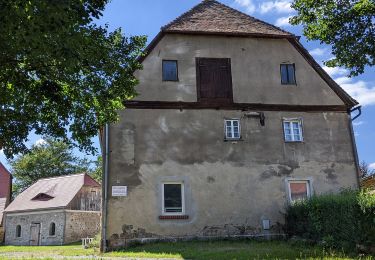
Trail On foot of 3.3 km to be discovered at Northeast, Liberecký kraj, Rynoltice. This trail is proposed by SityTrail - itinéraires balisés pédestres.
Trail created by cz:KČT.
![Trail On foot Rynoltice - [Z] Rynoltice -Jitrava - Photo 1](https://media.geolcdn.com/t/2048/auto/4414dee3-92dd-460a-958d-c0df7e8b4863.jpeg&format=jpg&maxdim=0 "Trail On foot Rynoltice - [Z] Rynoltice -Jitrava - Photo 1")
![Trail On foot Rynoltice - [Z] Rynoltice -Jitrava - Photo 2](https://media.geolcdn.com/t/2048/auto/9981efe0-1dd0-4b82-a7c4-1efec0dd283e.jpeg&format=jpg&maxdim=0 "Trail On foot Rynoltice - [Z] Rynoltice -Jitrava - Photo 2")
![Trail On foot Rynoltice - [Z] Rynoltice -Jitrava - Photo 3](https://media.geolcdn.com/t/2048/auto/bc3bb1fd-406f-4ebb-b1ac-1f2fcdc7f099.jpeg&format=jpg&maxdim=0 "Trail On foot Rynoltice - [Z] Rynoltice -Jitrava - Photo 3")
![Trail On foot Rynoltice - [Z] Rynoltice -Jitrava - Photo 4](https://media.geolcdn.com/t/2048/auto/7e2d9626-cf72-4556-8bc1-13a4699440a5.jpeg&format=jpg&maxdim=0 "Trail On foot Rynoltice - [Z] Rynoltice -Jitrava - Photo 4")
![Trail On foot Rynoltice - [Z] Rynoltice -Jitrava - Photo 5](https://media.geolcdn.com/t/2048/auto/991ba0ff-e26e-46d9-8cd6-0ba314ff0165.jpeg&format=jpg&maxdim=0 "Trail On foot Rynoltice - [Z] Rynoltice -Jitrava - Photo 5")
![Trail On foot Rynoltice - [Z] Rynoltice -Jitrava - Photo 6](https://media.geolcdn.com/t/2048/auto/6096cdb1-c77d-4089-bc6f-2e1788b22b23.jpeg&format=jpg&maxdim=0 "Trail On foot Rynoltice - [Z] Rynoltice -Jitrava - Photo 6")
![Trail On foot Rynoltice - [Z] Rynoltice -Jitrava - Photo 7](https://media.geolcdn.com/t/2048/auto/f37fd31b-7807-40af-88e7-d5d4b4d33314.jpeg&format=jpg&maxdim=0 "Trail On foot Rynoltice - [Z] Rynoltice -Jitrava - Photo 7")
![Trail On foot Rynoltice - [Z] Rynoltice -Jitrava - Photo 8](https://media.geolcdn.com/t/2048/auto/a39c520e-6e2c-4bb4-a355-dc3898405804.jpeg&format=jpg&maxdim=0 "Trail On foot Rynoltice - [Z] Rynoltice -Jitrava - Photo 8")
![Trail On foot Rynoltice - [Z] Rynoltice -Jitrava - Photo 9](https://media.geolcdn.com/t/2048/auto/2623bb98-2022-4fcc-b509-cb7bb1863308.jpeg&format=jpg&maxdim=0 "Trail On foot Rynoltice - [Z] Rynoltice -Jitrava - Photo 9")
![Trail On foot Rynoltice - [Z] Rynoltice -Jitrava - Photo 10](https://media.geolcdn.com/t/2048/auto/6d77d54b-5bfe-486d-be52-f4a62639b639.jpeg&format=jpg&maxdim=0 "Trail On foot Rynoltice - [Z] Rynoltice -Jitrava - Photo 10")
On foot
![Trail On foot Hrádek nad Nisou - [M] Hrádek nad Nisou (okruh) - Photo](https://media.geolcdn.com/t/375/260/6f4bfcbc-88e0-401e-bed7-00090c8df757.jpeg&format=jpg&maxdim=2)
On foot
![Trail On foot Zdislava - [Ž] Trávník-Pod Roimundem - Photo](https://media.geolcdn.com/t/375/260/c7b1925b-2e9f-49a3-b671-082298ba5d4b.jpeg&format=jpg&maxdim=2)
On foot