


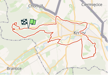

11.2 km | 13.9 km-effort
![Trail On foot Krnov - [Č] okruh kolem Krnova - Photo](https://media.geolcdn.com/t/1900/400/0c9d8cbf-3608-4e3b-bb39-83d0370a4b42.jpeg&format=pjpeg&maxdim=2)

Tous les sentiers balisés d’Europe GUIDE+


FREE GPS app for hiking
 SityTrail
IGN / Geographical institutes
SityTrail World
The world is yours!
Trail On foot of 24 km to be discovered at Moravia-Silesia, Moravskoslezský kraj, Krnov. This trail is proposed by SityTrail - itinéraires balisés pédestres.
Trail created by cz:KČT.
![Trail On foot Krnov - [Č] okruh kolem Krnova - Photo 1](https://media.geolcdn.com/t/2048/auto/32796e85-5396-414b-9b96-425232838694.jpeg&format=jpg&maxdim=0 "Trail On foot Krnov - [Č] okruh kolem Krnova - Photo 1")
![Trail On foot Krnov - [Č] okruh kolem Krnova - Photo 2](https://media.geolcdn.com/t/2048/auto/8f41df38-f259-42af-ace4-9f0b50dfa44b.jpeg&format=jpg&maxdim=0 "Trail On foot Krnov - [Č] okruh kolem Krnova - Photo 2")
![Trail On foot Krnov - [Č] okruh kolem Krnova - Photo 3](https://media.geolcdn.com/t/2048/auto/0fe517d3-b757-4632-945c-0d647417fc06.jpeg&format=jpg&maxdim=0 "Trail On foot Krnov - [Č] okruh kolem Krnova - Photo 3")
![Trail On foot Krnov - [Č] okruh kolem Krnova - Photo 4](https://media.geolcdn.com/t/2048/auto/e6077f58-3cc3-4ca6-9a89-a3d84d05dbc5.jpeg&format=jpg&maxdim=0 "Trail On foot Krnov - [Č] okruh kolem Krnova - Photo 4")
![Trail On foot Krnov - [Č] okruh kolem Krnova - Photo 5](https://media.geolcdn.com/t/2048/auto/56e72422-42bf-48e3-a7d0-1f8851247c28.jpeg&format=jpg&maxdim=0 "Trail On foot Krnov - [Č] okruh kolem Krnova - Photo 5")
![Trail On foot Krnov - [Č] okruh kolem Krnova - Photo 6](https://media.geolcdn.com/t/2048/auto/d2fdeb69-0735-4e81-bf59-0e93646c1559.jpeg&format=jpg&maxdim=0 "Trail On foot Krnov - [Č] okruh kolem Krnova - Photo 6")
![Trail On foot Krnov - [Č] okruh kolem Krnova - Photo 7](https://media.geolcdn.com/t/2048/auto/3a4c3c95-63b9-44f2-a44f-7289d5071b66.jpeg&format=jpg&maxdim=0 "Trail On foot Krnov - [Č] okruh kolem Krnova - Photo 7")
![Trail On foot Krnov - [Č] okruh kolem Krnova - Photo 8](https://media.geolcdn.com/t/2048/auto/a8ab3380-d28b-456c-a2de-dd8867fdd7a4.jpeg&format=jpg&maxdim=0 "Trail On foot Krnov - [Č] okruh kolem Krnova - Photo 8")
![Trail On foot Krnov - [Č] okruh kolem Krnova - Photo 9](https://media.geolcdn.com/t/2048/auto/bdd321e9-a751-4aee-91f3-5ff8a4688f5f.jpeg&format=jpg&maxdim=0 "Trail On foot Krnov - [Č] okruh kolem Krnova - Photo 9")
![Trail On foot Krnov - [Č] okruh kolem Krnova - Photo 10](https://media.geolcdn.com/t/2048/auto/0c9d8cbf-3608-4e3b-bb39-83d0370a4b42.jpeg&format=jpg&maxdim=0 "Trail On foot Krnov - [Č] okruh kolem Krnova - Photo 10")
On foot