


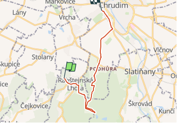

13.9 km | 17.9 km-effort
![Trail On foot Rabštejnská Lhota - [Ž] Chrudim - Podhůra - Rabštejnská Lhota - Photo](https://media.geolcdn.com/t/1900/400/a13872a9-b837-4337-b291-a43ad8f7a8bb.jpeg&format=pjpeg&maxdim=2)

Tous les sentiers balisés d’Europe GUIDE+


FREE GPS app for hiking
 SityTrail
IGN / Geographical institutes
SityTrail World
The world is yours!
Trail On foot of 9.1 km to be discovered at Northeast, Pardubický kraj, Rabštejnská Lhota. This trail is proposed by SityTrail - itinéraires balisés pédestres.
Trail created by cz:KČT.
![Trail On foot Rabštejnská Lhota - [Ž] Chrudim - Podhůra - Rabštejnská Lhota - Photo 1](https://media.geolcdn.com/t/2048/auto/739ad940-8031-4c94-b30f-ed517970669d.jpeg&format=jpg&maxdim=0 "Trail On foot Rabštejnská Lhota - [Ž] Chrudim - Podhůra - Rabštejnská Lhota - Photo 1")
![Trail On foot Rabštejnská Lhota - [Ž] Chrudim - Podhůra - Rabštejnská Lhota - Photo 2](https://media.geolcdn.com/t/2048/auto/adaafb95-9b17-47ea-be20-f335c21f49d5.jpeg&format=jpg&maxdim=0 "Trail On foot Rabštejnská Lhota - [Ž] Chrudim - Podhůra - Rabštejnská Lhota - Photo 2")
![Trail On foot Rabštejnská Lhota - [Ž] Chrudim - Podhůra - Rabštejnská Lhota - Photo 3](https://media.geolcdn.com/t/2048/auto/b23471e6-d71d-43df-9127-83ec9ed941b8.jpeg&format=jpg&maxdim=0 "Trail On foot Rabštejnská Lhota - [Ž] Chrudim - Podhůra - Rabštejnská Lhota - Photo 3")
![Trail On foot Rabštejnská Lhota - [Ž] Chrudim - Podhůra - Rabštejnská Lhota - Photo 4](https://media.geolcdn.com/t/2048/auto/19e8443e-3b7b-4674-8968-794b63133ec8.jpeg&format=jpg&maxdim=0 "Trail On foot Rabštejnská Lhota - [Ž] Chrudim - Podhůra - Rabštejnská Lhota - Photo 4")
![Trail On foot Rabštejnská Lhota - [Ž] Chrudim - Podhůra - Rabštejnská Lhota - Photo 5](https://media.geolcdn.com/t/2048/auto/c6ed41d1-3b17-4402-b951-9c04fca3c3e8.jpeg&format=jpg&maxdim=0 "Trail On foot Rabštejnská Lhota - [Ž] Chrudim - Podhůra - Rabštejnská Lhota - Photo 5")
![Trail On foot Rabštejnská Lhota - [Ž] Chrudim - Podhůra - Rabštejnská Lhota - Photo 6](https://media.geolcdn.com/t/2048/auto/57707fdd-b385-456f-bf95-21dff30290be.jpeg&format=jpg&maxdim=0 "Trail On foot Rabštejnská Lhota - [Ž] Chrudim - Podhůra - Rabštejnská Lhota - Photo 6")
![Trail On foot Rabštejnská Lhota - [Ž] Chrudim - Podhůra - Rabštejnská Lhota - Photo 7](https://media.geolcdn.com/t/2048/auto/36f422c5-567a-417b-9292-f1c3b3790055.jpeg&format=jpg&maxdim=0 "Trail On foot Rabštejnská Lhota - [Ž] Chrudim - Podhůra - Rabštejnská Lhota - Photo 7")
![Trail On foot Rabštejnská Lhota - [Ž] Chrudim - Podhůra - Rabštejnská Lhota - Photo 8](https://media.geolcdn.com/t/2048/auto/e0e20ca5-a9a9-41b1-9a89-96a846f07896.jpeg&format=jpg&maxdim=0 "Trail On foot Rabštejnská Lhota - [Ž] Chrudim - Podhůra - Rabštejnská Lhota - Photo 8")
![Trail On foot Rabštejnská Lhota - [Ž] Chrudim - Podhůra - Rabštejnská Lhota - Photo 9](https://media.geolcdn.com/t/2048/auto/85bbb3a3-286c-4d0f-9806-2545554da6a3.jpeg&format=jpg&maxdim=0 "Trail On foot Rabštejnská Lhota - [Ž] Chrudim - Podhůra - Rabštejnská Lhota - Photo 9")
![Trail On foot Rabštejnská Lhota - [Ž] Chrudim - Podhůra - Rabštejnská Lhota - Photo 10](https://media.geolcdn.com/t/2048/auto/a13872a9-b837-4337-b291-a43ad8f7a8bb.jpeg&format=jpg&maxdim=0 "Trail On foot Rabštejnská Lhota - [Ž] Chrudim - Podhůra - Rabštejnská Lhota - Photo 10")
![Trail On foot Semtěš - [Ž] Konopáč - Semtěš - Photo](https://media.geolcdn.com/t/375/260/4b4cb51a-3f87-4840-8d60-7e3ab3cd869f.jpeg&format=jpg&maxdim=2)
On foot
On foot
![Trail On foot České Lhotice - [Z] Libáň - Křižanovická přehrada - Photo](https://media.geolcdn.com/t/375/260/2ce85a53-5231-488f-9215-22bd0c81978f.jpeg&format=jpg&maxdim=2)
On foot
![Trail On foot Vápenný Podol - [Z] Vápenný Podol - Lovětínská rokle - Photo](https://media.geolcdn.com/t/375/260/ed4a2dcc-90b9-41d4-a6f1-952f7b0de326.jpeg&format=jpg&maxdim=2)
On foot
On foot
![Trail On foot Běstvina - [Z] Běstvina - Seč - Photo](https://media.geolcdn.com/t/375/260/1fe36d45-751d-4c3f-8910-968f469449fc.jpeg&format=jpg&maxdim=2)
On foot
![Trail On foot Valy - [Č] Heřmanův Městec - Lepějovice - Photo](https://media.geolcdn.com/t/375/260/54f32eee-5fd1-4854-b492-42524c595dd4.jpeg&format=jpg&maxdim=2)
On foot
![Trail On foot Kladruby nad Labem - [Č] Kladruby - Přelouč - Photo](https://media.geolcdn.com/t/375/260/f96fe7b0-7312-4d06-9975-7d9efd906da9.jpeg&format=jpg&maxdim=2)
On foot
![Trail On foot Břehy - [Ž] Černý Nadýmač - okruh - Photo](https://media.geolcdn.com/t/375/260/479c30b1-2ae0-479c-bb59-7778ea6d1886.jpeg&format=jpg&maxdim=2)
On foot