


3.8 km | 4.2 km-effort
![Trail On foot Štětí - [M] Štětí - Ledčice - Photo](https://media.geolcdn.com/t/1900/400/bec04fab-17ef-4ed8-9aa1-9f79da79c802.jpeg&format=pjpeg&maxdim=2)

Tous les sentiers balisés d’Europe GUIDE+


FREE GPS app for hiking
 SityTrail
IGN / Geographical institutes
SityTrail World
The world is yours!
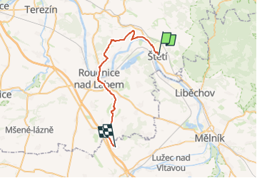
Trail On foot of 28 km to be discovered at Northwest, Ústecký kraj, Štětí. This trail is proposed by SityTrail - itinéraires balisés pédestres.
Trail created by cz:KČT.
![Trail On foot Štětí - [M] Štětí - Ledčice - Photo 1](https://media.geolcdn.com/t/2048/auto/ed27c355-96a1-4133-bbd1-e2deab0f15b8.jpeg&format=jpg&maxdim=0 "Trail On foot Štětí - [M] Štětí - Ledčice - Photo 1")
![Trail On foot Štětí - [M] Štětí - Ledčice - Photo 2](https://media.geolcdn.com/t/2048/auto/fe8aebbe-c99d-4049-bfe6-913b54ea5fee.jpeg&format=jpg&maxdim=0 "Trail On foot Štětí - [M] Štětí - Ledčice - Photo 2")
![Trail On foot Štětí - [M] Štětí - Ledčice - Photo 3](https://media.geolcdn.com/t/2048/auto/7d8bcbbe-dde3-4603-bc1d-8f7677cffbdf.jpeg&format=jpg&maxdim=0 "Trail On foot Štětí - [M] Štětí - Ledčice - Photo 3")
![Trail On foot Štětí - [M] Štětí - Ledčice - Photo 4](https://media.geolcdn.com/t/2048/auto/ded1e57c-672a-4d99-bac7-43154518c372.jpeg&format=jpg&maxdim=0 "Trail On foot Štětí - [M] Štětí - Ledčice - Photo 4")
![Trail On foot Štětí - [M] Štětí - Ledčice - Photo 5](https://media.geolcdn.com/t/2048/auto/1de0a485-22e2-4c69-9675-31f8ca6320bc.jpeg&format=jpg&maxdim=0 "Trail On foot Štětí - [M] Štětí - Ledčice - Photo 5")
![Trail On foot Štětí - [M] Štětí - Ledčice - Photo 6](https://media.geolcdn.com/t/2048/auto/b3e4912f-c404-4a6a-9ccd-66761535cd0c.jpeg&format=jpg&maxdim=0 "Trail On foot Štětí - [M] Štětí - Ledčice - Photo 6")
![Trail On foot Štětí - [M] Štětí - Ledčice - Photo 7](https://media.geolcdn.com/t/2048/auto/cdb43f0c-8273-4652-bd24-7be553bacc1c.jpeg&format=jpg&maxdim=0 "Trail On foot Štětí - [M] Štětí - Ledčice - Photo 7")
![Trail On foot Štětí - [M] Štětí - Ledčice - Photo 8](https://media.geolcdn.com/t/2048/auto/6b308111-598b-4afc-b0d0-9365bdec7693.jpeg&format=jpg&maxdim=0 "Trail On foot Štětí - [M] Štětí - Ledčice - Photo 8")
![Trail On foot Štětí - [M] Štětí - Ledčice - Photo 9](https://media.geolcdn.com/t/2048/auto/932f1760-17a5-4658-9967-583dff9c9f65.jpeg&format=jpg&maxdim=0 "Trail On foot Štětí - [M] Štětí - Ledčice - Photo 9")
![Trail On foot Štětí - [M] Štětí - Ledčice - Photo 10](https://media.geolcdn.com/t/2048/auto/bec04fab-17ef-4ed8-9aa1-9f79da79c802.jpeg&format=jpg&maxdim=0 "Trail On foot Štětí - [M] Štětí - Ledčice - Photo 10")
On foot
On foot