


10.5 km | 12.1 km-effort
![Trail On foot Chlum u Třeboně - [M] Chlum u Třeboně - Majdalena - Photo](https://media.geolcdn.com/t/1900/400/c5b3127b-51b9-444c-873e-2820e6bdc5ba.jpeg&format=pjpeg&maxdim=2)

Tous les sentiers balisés d’Europe GUIDE+


FREE GPS app for hiking
 SityTrail
IGN / Geographical institutes
SityTrail World
The world is yours!
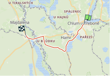
Trail On foot of 7 km to be discovered at Southwest, Jihočeský kraj, Chlum u Třeboně. This trail is proposed by SityTrail - itinéraires balisés pédestres.
Trail created by cz:KČT.
![Trail On foot Chlum u Třeboně - [M] Chlum u Třeboně - Majdalena - Photo 1](https://media.geolcdn.com/t/2048/auto/5f11d322-b79c-40d9-a4ee-334edb8a79b1.jpeg&format=jpg&maxdim=0 "Trail On foot Chlum u Třeboně - [M] Chlum u Třeboně - Majdalena - Photo 1")
![Trail On foot Chlum u Třeboně - [M] Chlum u Třeboně - Majdalena - Photo 2](https://media.geolcdn.com/t/2048/auto/5fff733c-7cb4-4e05-97f6-f8ec1de92b8b.jpeg&format=jpg&maxdim=0 "Trail On foot Chlum u Třeboně - [M] Chlum u Třeboně - Majdalena - Photo 2")
![Trail On foot Chlum u Třeboně - [M] Chlum u Třeboně - Majdalena - Photo 3](https://media.geolcdn.com/t/2048/auto/af550c50-8893-42c7-8ce4-9ae3d4127c8a.jpeg&format=jpg&maxdim=0 "Trail On foot Chlum u Třeboně - [M] Chlum u Třeboně - Majdalena - Photo 3")
![Trail On foot Chlum u Třeboně - [M] Chlum u Třeboně - Majdalena - Photo 4](https://media.geolcdn.com/t/2048/auto/7959cdd4-4fa7-4430-b205-b9509b7fb44b.jpeg&format=jpg&maxdim=0 "Trail On foot Chlum u Třeboně - [M] Chlum u Třeboně - Majdalena - Photo 4")
![Trail On foot Chlum u Třeboně - [M] Chlum u Třeboně - Majdalena - Photo 5](https://media.geolcdn.com/t/2048/auto/179d257b-7ab1-4bcf-946e-0e06af09cdc2.jpeg&format=jpg&maxdim=0 "Trail On foot Chlum u Třeboně - [M] Chlum u Třeboně - Majdalena - Photo 5")
![Trail On foot Chlum u Třeboně - [M] Chlum u Třeboně - Majdalena - Photo 6](https://media.geolcdn.com/t/2048/auto/afab4402-cd95-4bf6-86d5-8064bc6db881.jpeg&format=jpg&maxdim=0 "Trail On foot Chlum u Třeboně - [M] Chlum u Třeboně - Majdalena - Photo 6")
![Trail On foot Chlum u Třeboně - [M] Chlum u Třeboně - Majdalena - Photo 7](https://media.geolcdn.com/t/2048/auto/dcdd4e85-d2fd-4080-a58f-e49c6364a5f4.jpeg&format=jpg&maxdim=0 "Trail On foot Chlum u Třeboně - [M] Chlum u Třeboně - Majdalena - Photo 7")
![Trail On foot Chlum u Třeboně - [M] Chlum u Třeboně - Majdalena - Photo 8](https://media.geolcdn.com/t/2048/auto/ab96ce28-1ba0-4ab3-b281-602eda844401.jpeg&format=jpg&maxdim=0 "Trail On foot Chlum u Třeboně - [M] Chlum u Třeboně - Majdalena - Photo 8")
![Trail On foot Chlum u Třeboně - [M] Chlum u Třeboně - Majdalena - Photo 9](https://media.geolcdn.com/t/2048/auto/487b58d0-c48e-4b12-bbb8-2819609bd257.jpeg&format=jpg&maxdim=0 "Trail On foot Chlum u Třeboně - [M] Chlum u Třeboně - Majdalena - Photo 9")
![Trail On foot Chlum u Třeboně - [M] Chlum u Třeboně - Majdalena - Photo 10](https://media.geolcdn.com/t/2048/auto/c5b3127b-51b9-444c-873e-2820e6bdc5ba.jpeg&format=jpg&maxdim=0 "Trail On foot Chlum u Třeboně - [M] Chlum u Třeboně - Majdalena - Photo 10")
On foot
![Trail On foot Chlum u Třeboně - [Z] Majdalena žst. - Starý Kanclíř - Photo](https://media.geolcdn.com/t/375/260/160cb673-a34f-4369-9d35-56dda7405eee.jpeg&format=jpg&maxdim=2)
On foot