![](/images/other/stat-length.png)
![Trail On foot Letiny - NS Čertovo břemeno - Photo](https://media.geolcdn.com/t/1900/400/80a70307-c5ea-41ef-9c70-40438b625d75.jpeg&format=pjpeg&maxdim=2)
NS Čertovo břemeno
SityTrail - itinéraires balisés pédestres
Tous les sentiers balisés d’Europe GUIDE+
![Length](/images/other/stat-length.png)
Length
16.9 km
![Max alt](https://static1.geolcdn.com/siteimages/upload/files/1508320355ic_sort_altitude_max_24dp.png)
Max alt
598 m
![Uphill gradient](https://static1.geolcdn.com/siteimages/upload/files/1508320355ic_sort_den_pos_24dp.png)
Uphill gradient
380 m
![Km-Effort](/images/other/stat-length.png)
Km-Effort
22 km
![Min alt](https://static1.geolcdn.com/siteimages/upload/files/1508320355ic_sort_altitude_min_24dp.png)
Min alt
455 m
![Downhill gradient](https://static1.geolcdn.com/siteimages/upload/files/1508320355ic_sort_den_neg_24dp.png)
Downhill gradient
382 m
![Boucle](https://static1.geolcdn.com/siteimages/upload/files/16400158638029165_repeat_loop_refresh_sync_direction_icon.png)
Boucle
No
Signpost
Creation date :
2025-02-07 02:38:22.302
Updated on :
2025-02-07 02:38:22.302
![On foot](https://static1.geolcdn.com/sitytour/trail-icons/100.png)
4h59
Difficulty : Medium
![Scan this QR Code to open this trail in the SityTrail application](https://capi.geolives.com/qq0zvz2zws4bq2lad0pu/sitytour/trails/4344473/qr.png?size=200)
FREE GPS app for hiking
About
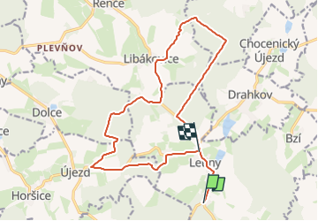
Trail On foot of 16.9 km to be discovered at Southwest, Plzeňský kraj, Letiny. This trail is proposed by SityTrail - itinéraires balisés pédestres.
Description
Trail created by cz:KČT.
Website: https://www.mas-aktivios.cz/naucne-stezky/
Positioning
Country:
Czech Republic
Region :
Southwest
Department/Province :
Plzeňský kraj
Municipality :
Letiny
Location:
Unknown
Start:(Dec)
Start:(UTM)
388141 ; 5487486 (33U) N.
Comments
Trails nearby
![Trail On foot Šťáhlavy - Naučná stezka Okolo Kozlu - Photo](https://media.geolcdn.com/t/375/260/6ab8b0a3-a73f-4f06-abb5-727e8ac683f0.jpeg&format=jpg&maxdim=2)
![On foot On foot](https://static1.geolcdn.com/sitytour/trail-icons/100.png)
Naučná stezka Okolo Kozlu
On foot
Easy
Šťáhlavy,
Southwest,
Plzeňský kraj,
Czech Republic
![](/images/other/stat-length.png)
3.3 km | 4.4 km-effort
59min
![](https://static1.geolcdn.com/siteimages/upload/files/16400158638029165_repeat_loop_refresh_sync_direction_icon.png)
Yes
![Trail On foot Přeštice - [Ž] Přeštice - Lužany - Photo](https://media.geolcdn.com/t/375/260/919f7a9d-8b8b-43c7-bd6f-9961dd11f649.jpeg&format=jpg&maxdim=2)
![On foot On foot](https://static1.geolcdn.com/sitytour/trail-icons/100.png)
[Ž] Přeštice - Lužany
On foot
Easy
Přeštice,
Southwest,
Plzeňský kraj,
Czech Republic
![](/images/other/stat-length.png)
5.3 km | 5.8 km-effort
1h 18min
![](https://static1.geolcdn.com/siteimages/upload/files/16400158638029165_repeat_loop_refresh_sync_direction_icon.png)
No
![Trail On foot Velký Bor - Újezd u Chanovic - Jetenovice (žst) - Photo](https://media.geolcdn.com/t/375/260/c97f9532-96e4-47f6-b96c-d91770aaa81f.jpeg&format=jpg&maxdim=2)
![On foot On foot](https://static1.geolcdn.com/sitytour/trail-icons/100.png)
Újezd u Chanovic - Jetenovice (žst)
On foot
Easy
Velký Bor,
Southwest,
Plzeňský kraj,
Czech Republic
![](/images/other/stat-length.png)
5.5 km | 6.8 km-effort
1h 33min
![](https://static1.geolcdn.com/siteimages/upload/files/16400158638029165_repeat_loop_refresh_sync_direction_icon.png)
No
![Trail On foot Nebílovy - [Z] Štěnovice - Nebílovy - Photo](https://media.geolcdn.com/t/375/260/78153f03-0394-41af-a8cb-63376f17de15.jpeg&format=jpg&maxdim=2)
![On foot On foot](https://static1.geolcdn.com/sitytour/trail-icons/100.png)
[Z] Štěnovice - Nebílovy
On foot
Easy
Nebílovy,
Southwest,
Plzeňský kraj,
Czech Republic
![](/images/other/stat-length.png)
10.3 km | 13.9 km-effort
3h 10min
![](https://static1.geolcdn.com/siteimages/upload/files/16400158638029165_repeat_loop_refresh_sync_direction_icon.png)
No
![Trail On foot Chotěšov - [Z] Chotěšov - Chudenice - Photo](https://media.geolcdn.com/t/375/260/db6e0667-71ef-4d53-8b64-8b347f6d468d.jpeg&format=jpg&maxdim=2)
![On foot On foot](https://static1.geolcdn.com/sitytour/trail-icons/100.png)
[Z] Chotěšov - Chudenice
On foot
Difficult
Chotěšov,
Southwest,
Plzeňský kraj,
Czech Republic
![](/images/other/stat-length.png)
29 km | 38 km-effort
8h 42min
![](https://static1.geolcdn.com/siteimages/upload/files/16400158638029165_repeat_loop_refresh_sync_direction_icon.png)
No
![Trail On foot Spálené Poříčí - [Ž] Spálené Pořičí - Zdemyslice - Photo](https://media.geolcdn.com/t/375/260/1a4b968e-35de-4a8f-97c7-3b18afeaa3c1.jpeg&format=jpg&maxdim=2)
![On foot On foot](https://static1.geolcdn.com/sitytour/trail-icons/100.png)
[Ž] Spálené Pořičí - Zdemyslice
On foot
Easy
Spálené Poříčí,
Southwest,
Plzeňský kraj,
Czech Republic
![](/images/other/stat-length.png)
8.2 km | 10.1 km-effort
2h 17min
![](https://static1.geolcdn.com/siteimages/upload/files/16400158638029165_repeat_loop_refresh_sync_direction_icon.png)
No
![Trail On foot Líně - [Č] Líňská okružní trasa - Photo](https://media.geolcdn.com/t/375/260/cbeb49cd-7fbd-4b7b-bd64-d76bac41e164.jpeg&format=jpg&maxdim=2)
![On foot On foot](https://static1.geolcdn.com/sitytour/trail-icons/100.png)
[Č] Líňská okružní trasa
On foot
Easy
Líně,
Southwest,
Plzeňský kraj,
Czech Republic
![](/images/other/stat-length.png)
12.1 km | 13.9 km-effort
3h 9min
![](https://static1.geolcdn.com/siteimages/upload/files/16400158638029165_repeat_loop_refresh_sync_direction_icon.png)
Yes
![Trail On foot Mirošov - NS Za černým diamantem - Photo](https://media.geolcdn.com/t/375/260/e493dc59-cc4a-4832-b7a0-dc1e624fccd2.jpeg&format=jpg&maxdim=2)
![On foot On foot](https://static1.geolcdn.com/sitytour/trail-icons/100.png)
NS Za černým diamantem
On foot
Easy
Mirošov,
Southwest,
Plzeňský kraj,
Czech Republic
![](/images/other/stat-length.png)
3.5 km | 4.2 km-effort
57min
![](https://static1.geolcdn.com/siteimages/upload/files/16400158638029165_repeat_loop_refresh_sync_direction_icon.png)
No
![Trail On foot Lužany - NS Živé paměti krajiny Lužan - Photo](https://media.geolcdn.com/t/375/260/a4827304-a4c3-448c-b66a-fa56fbf34032.jpeg&format=jpg&maxdim=2)
![On foot On foot](https://static1.geolcdn.com/sitytour/trail-icons/100.png)
NS Živé paměti krajiny Lužan
On foot
Easy
Lužany,
Southwest,
Plzeňský kraj,
Czech Republic
![](/images/other/stat-length.png)
6.4 km | 8.3 km-effort
1h 53min
![](https://static1.geolcdn.com/siteimages/upload/files/16400158638029165_repeat_loop_refresh_sync_direction_icon.png)
No