![](/images/other/stat-length.png)
![Trail On foot Volyně - [Č] 0117 Strakonice - Mařský vrch - Photo](https://media.geolcdn.com/t/1900/400/ext.pjpeg?maxdim=2&url=https%3A%2F%2Fstatic1.geolcdn.com%2Fsiteimages%2Fupload%2Ffiles%2F1545311037marcheuse_200dpi.jpg)
[Č] 0117 Strakonice - Mařský vrch
SityTrail - itinéraires balisés pédestres
Tous les sentiers balisés d’Europe GUIDE+
![Length](/images/other/stat-length.png)
Length
17.3 km
![Max alt](https://static1.geolcdn.com/siteimages/upload/files/1508320355ic_sort_altitude_max_24dp.png)
Max alt
909 m
![Uphill gradient](https://static1.geolcdn.com/siteimages/upload/files/1508320355ic_sort_den_pos_24dp.png)
Uphill gradient
639 m
![Km-Effort](/images/other/stat-length.png)
Km-Effort
24 km
![Min alt](https://static1.geolcdn.com/siteimages/upload/files/1508320355ic_sort_altitude_min_24dp.png)
Min alt
442 m
![Downhill gradient](https://static1.geolcdn.com/siteimages/upload/files/1508320355ic_sort_den_neg_24dp.png)
Downhill gradient
181 m
![Boucle](https://static1.geolcdn.com/siteimages/upload/files/16400158638029165_repeat_loop_refresh_sync_direction_icon.png)
Boucle
No
Signpost
Creation date :
2025-02-07 02:35:46.331
Updated on :
2025-02-07 02:35:46.331
![On foot](https://static1.geolcdn.com/sitytour/trail-icons/100.png)
5h31
Difficulty : Medium
![Scan this QR Code to open this trail in the SityTrail application](https://capi.geolives.com/qq0zvz2zws4bq2lad0pu/sitytour/trails/4344470/qr.png?size=200)
FREE GPS app for hiking
About
Trail On foot of 17.3 km to be discovered at Southwest, Jihočeský kraj, Volyně. This trail is proposed by SityTrail - itinéraires balisés pédestres.
Description
Trail created by cz:KČT.
u Vimperka je asi 200 m vedena spolu s trasou 1075
Positioning
Country:
Czech Republic
Region :
Southwest
Department/Province :
Jihočeský kraj
Municipality :
Volyně
Location:
Unknown
Start:(Dec)
Start:(UTM)
419239 ; 5446960 (33U) N.
Comments
Trails nearby
![Trail On foot Písek - [Č] Písek - Velká Brašna - Photo](https://media.geolcdn.com/t/375/260/bfca88cd-0504-44c2-9a66-8e406f087387.jpeg&format=jpg&maxdim=2)
![On foot On foot](https://static1.geolcdn.com/sitytour/trail-icons/100.png)
[Č] Písek - Velká Brašna
On foot
Easy
Písek,
Southwest,
Jihočeský kraj,
Czech Republic
![](/images/other/stat-length.png)
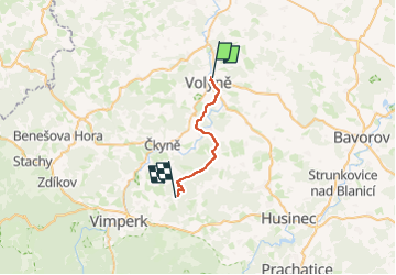
6.3 km | 8.9 km-effort
2h 1min
![](https://static1.geolcdn.com/siteimages/upload/files/16400158638029165_repeat_loop_refresh_sync_direction_icon.png)
No
![Trail On foot Vimperk - NS Údolím vimperských památek - část okolí města - Photo](https://media.geolcdn.com/t/375/260/0c3278c4-22c6-443a-9272-3a8fb3625d46.jpeg&format=jpg&maxdim=2)
![On foot On foot](https://static1.geolcdn.com/sitytour/trail-icons/100.png)
NS Údolím vimperských památek - část okolí města
On foot
Easy
Vimperk,
Southwest,
Jihočeský kraj,
Czech Republic
![](/images/other/stat-length.png)
6.4 km | 9.4 km-effort
2h 8min
![](https://static1.geolcdn.com/siteimages/upload/files/16400158638029165_repeat_loop_refresh_sync_direction_icon.png)
Yes
![Trail On foot Písek - NS Školní polesí - Hůrka - Photo](https://media.geolcdn.com/t/375/260/7133faff-b21d-41b6-9f51-c54858ab31a0.jpeg&format=jpg&maxdim=2)
![On foot On foot](https://static1.geolcdn.com/sitytour/trail-icons/100.png)
NS Školní polesí - Hůrka
On foot
Easy
Písek,
Southwest,
Jihočeský kraj,
Czech Republic
![](/images/other/stat-length.png)
9.5 km | 12 km-effort
2h 43min
![](https://static1.geolcdn.com/siteimages/upload/files/16400158638029165_repeat_loop_refresh_sync_direction_icon.png)
Yes
![Trail On foot Volenice - NS Boží kámen - Photo](https://media.geolcdn.com/t/375/260/4623a922-1d9c-4365-b7ea-a8b7563717d1.jpeg&format=jpg&maxdim=2)
![On foot On foot](https://static1.geolcdn.com/sitytour/trail-icons/100.png)
NS Boží kámen
On foot
Easy
Volenice,
Southwest,
Jihočeský kraj,
Czech Republic
![](/images/other/stat-length.png)
4.6 km | 7 km-effort
1h 35min
![](https://static1.geolcdn.com/siteimages/upload/files/16400158638029165_repeat_loop_refresh_sync_direction_icon.png)
Yes
![Trail On foot Vodňany - Turisticko NS Vodňanská - Photo](https://media.geolcdn.com/t/375/260/f0c5e510-1596-458a-ba5f-018c597cf067.jpeg&format=jpg&maxdim=2)
![On foot On foot](https://static1.geolcdn.com/sitytour/trail-icons/100.png)
Turisticko NS Vodňanská
On foot
Easy
Vodňany,
Southwest,
Jihočeský kraj,
Czech Republic
![](/images/other/stat-length.png)
3.7 km | 3.9 km-effort
53min
![](https://static1.geolcdn.com/siteimages/upload/files/16400158638029165_repeat_loop_refresh_sync_direction_icon.png)
No
![Trail On foot Záblatí - Naučná stezka Na soutoku - Photo](https://media.geolcdn.com/t/375/260/a8995b26-dc79-4fd3-a478-1d5987d5ea23.jpeg&format=jpg&maxdim=2)
![On foot On foot](https://static1.geolcdn.com/sitytour/trail-icons/100.png)
Naučná stezka Na soutoku
On foot
Easy
Záblatí,
Southwest,
Jihočeský kraj,
Czech Republic
![](/images/other/stat-length.png)
3.1 km | 4.2 km-effort
56min
![](https://static1.geolcdn.com/siteimages/upload/files/16400158638029165_repeat_loop_refresh_sync_direction_icon.png)
No
![Trail On foot Vlachovo Březí - Vlachovo Březí - tDolni Kožlí - Photo](https://media.geolcdn.com/t/375/260/824563b7-bea3-4745-b85a-d7cc365129ab.jpeg&format=jpg&maxdim=2)
![On foot On foot](https://static1.geolcdn.com/sitytour/trail-icons/100.png)
Vlachovo Březí - tDolni Kožlí
On foot
Easy
Vlachovo Březí,
Southwest,
Jihočeský kraj,
Czech Republic
![](/images/other/stat-length.png)
3.1 km | 3.9 km-effort
52min
![](https://static1.geolcdn.com/siteimages/upload/files/16400158638029165_repeat_loop_refresh_sync_direction_icon.png)
No
![Trail On foot Radhostice - Šár - Libotyně - Vlachovo Březí - Photo](https://media.geolcdn.com/t/375/260/9b02bdab-57a8-40b0-87bd-43c0546ee19e.jpeg&format=jpg&maxdim=2)
![On foot On foot](https://static1.geolcdn.com/sitytour/trail-icons/100.png)
Šár - Libotyně - Vlachovo Březí
On foot
Easy
Radhostice,
Southwest,
Jihočeský kraj,
Czech Republic
![](/images/other/stat-length.png)
8.6 km | 11.3 km-effort
2h 34min
![](https://static1.geolcdn.com/siteimages/upload/files/16400158638029165_repeat_loop_refresh_sync_direction_icon.png)
No
![Trail On foot Dub - [Z] Strunkovice nad Blanicí - Čarouše - Photo](https://media.geolcdn.com/t/375/260/b0128167-a05a-4c37-8e7a-3c52dc19c376.jpeg&format=jpg&maxdim=2)
![On foot On foot](https://static1.geolcdn.com/sitytour/trail-icons/100.png)
[Z] Strunkovice nad Blanicí - Čarouše
On foot
Easy
Dub,
Southwest,
Jihočeský kraj,
Czech Republic
![](/images/other/stat-length.png)
3.9 km | 4.9 km-effort
1h 6min
![](https://static1.geolcdn.com/siteimages/upload/files/16400158638029165_repeat_loop_refresh_sync_direction_icon.png)
No