


3.3 km | 4.1 km-effort
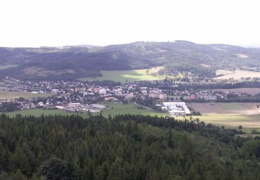
![Trail On foot Město Albrechtice - [Ž] Albrechtice - Petrovy boudy - Photo](https://media.geolcdn.com/t/1900/400/f4747928-09d6-4159-b288-1d744968c1cc.jpeg&format=pjpeg&maxdim=2)

Tous les sentiers balisés d’Europe GUIDE+


FREE GPS app for hiking
 SityTrail
IGN / Geographical institutes
SityTrail World
The world is yours!
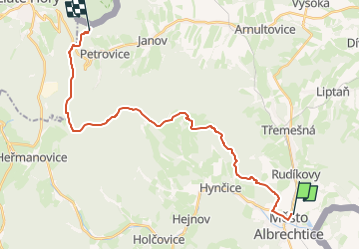
Trail On foot of 22 km to be discovered at Moravia-Silesia, Moravskoslezský kraj, Město Albrechtice. This trail is proposed by SityTrail - itinéraires balisés pédestres.
Trail created by cz:KČT.
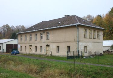
![Trail On foot Město Albrechtice - [Ž] Albrechtice - Petrovy boudy - Photo 1](https://media.geolcdn.com/t/2048/auto/668e9f76-8475-451a-967f-633eb9178d2f.jpeg&format=jpg&maxdim=0 "Trail On foot Město Albrechtice - [Ž] Albrechtice - Petrovy boudy - Photo 1")
![Trail On foot Město Albrechtice - [Ž] Albrechtice - Petrovy boudy - Photo 2](https://media.geolcdn.com/t/2048/auto/0c372021-188c-45fe-aec6-cc490cff40c9.jpeg&format=jpg&maxdim=0 "Trail On foot Město Albrechtice - [Ž] Albrechtice - Petrovy boudy - Photo 2")
![Trail On foot Město Albrechtice - [Ž] Albrechtice - Petrovy boudy - Photo 3](https://media.geolcdn.com/t/2048/auto/8bdff951-7518-437d-a7a2-a60972c25193.jpeg&format=jpg&maxdim=0 "Trail On foot Město Albrechtice - [Ž] Albrechtice - Petrovy boudy - Photo 3")
![Trail On foot Město Albrechtice - [Ž] Albrechtice - Petrovy boudy - Photo 4](https://media.geolcdn.com/t/2048/auto/a400139c-1544-42b2-8556-0dc1fb05dc18.jpeg&format=jpg&maxdim=0 "Trail On foot Město Albrechtice - [Ž] Albrechtice - Petrovy boudy - Photo 4")
![Trail On foot Město Albrechtice - [Ž] Albrechtice - Petrovy boudy - Photo 5](https://media.geolcdn.com/t/2048/auto/71a2ca10-9765-44fa-b01a-89152dd82c9d.jpeg&format=jpg&maxdim=0 "Trail On foot Město Albrechtice - [Ž] Albrechtice - Petrovy boudy - Photo 5")
![Trail On foot Město Albrechtice - [Ž] Albrechtice - Petrovy boudy - Photo 6](https://media.geolcdn.com/t/2048/auto/b13c12d6-68e0-4dcf-a5ad-876af806ecfe.jpeg&format=jpg&maxdim=0 "Trail On foot Město Albrechtice - [Ž] Albrechtice - Petrovy boudy - Photo 6")
![Trail On foot Město Albrechtice - [Ž] Albrechtice - Petrovy boudy - Photo 7](https://media.geolcdn.com/t/2048/auto/f4747928-09d6-4159-b288-1d744968c1cc.jpeg&format=jpg&maxdim=0 "Trail On foot Město Albrechtice - [Ž] Albrechtice - Petrovy boudy - Photo 7")
![Trail On foot Město Albrechtice - [Ž] Albrechtice - Petrovy boudy - Photo 8](https://media.geolcdn.com/t/2048/auto/7754d603-6516-478a-b100-15068f4c7cfb.jpeg&format=jpg&maxdim=0 "Trail On foot Město Albrechtice - [Ž] Albrechtice - Petrovy boudy - Photo 8")
![Trail On foot Město Albrechtice - [Ž] Albrechtice - Petrovy boudy - Photo 9](https://media.geolcdn.com/t/2048/auto/04629276-1a2f-4333-88d8-f7e78b828cb9.jpeg&format=jpg&maxdim=0 "Trail On foot Město Albrechtice - [Ž] Albrechtice - Petrovy boudy - Photo 9")
![Trail On foot Město Albrechtice - [Ž] Albrechtice - Petrovy boudy - Photo 10](https://media.geolcdn.com/t/2048/auto/a507b912-14bf-44a4-8e07-341d19abfd85.jpeg&format=jpg&maxdim=0 "Trail On foot Město Albrechtice - [Ž] Albrechtice - Petrovy boudy - Photo 10")
On foot
On foot