


3.3 km | 5.2 km-effort
![Trail On foot Hroznětín - [Ž] Oldřišský vrch - Oldříš - Pod Skálami - Photo](https://media.geolcdn.com/t/1900/400/3c3a6ac5-78bd-4faf-9425-12c8b75c7677.jpeg&format=pjpeg&maxdim=2)

Tous les sentiers balisés d’Europe GUIDE+


FREE GPS app for hiking
 SityTrail
IGN / Geographical institutes
SityTrail World
The world is yours!
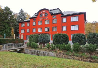
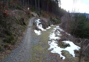
Trail On foot of 3.1 km to be discovered at Northwest, Karlovarský kraj, Hroznětín. This trail is proposed by SityTrail - itinéraires balisés pédestres.
Trail created by cz:KČT.
žlutá: Oldřišský vrch-Oldříš
![Trail On foot Hroznětín - [Ž] Oldřišský vrch - Oldříš - Pod Skálami - Photo 1](https://media.geolcdn.com/t/2048/auto/f76aff18-286f-45aa-938a-744723634a8d.jpeg&format=jpg&maxdim=0 "Trail On foot Hroznětín - [Ž] Oldřišský vrch - Oldříš - Pod Skálami - Photo 1")
![Trail On foot Hroznětín - [Ž] Oldřišský vrch - Oldříš - Pod Skálami - Photo 2](https://media.geolcdn.com/t/2048/auto/cee611d7-f57c-4ce8-99a8-29f86d8e59a9.jpeg&format=jpg&maxdim=0 "Trail On foot Hroznětín - [Ž] Oldřišský vrch - Oldříš - Pod Skálami - Photo 2")
![Trail On foot Hroznětín - [Ž] Oldřišský vrch - Oldříš - Pod Skálami - Photo 3](https://media.geolcdn.com/t/2048/auto/ecffad93-a4fd-433e-8e99-2f8a1feb8508.jpeg&format=jpg&maxdim=0 "Trail On foot Hroznětín - [Ž] Oldřišský vrch - Oldříš - Pod Skálami - Photo 3")
![Trail On foot Hroznětín - [Ž] Oldřišský vrch - Oldříš - Pod Skálami - Photo 4](https://media.geolcdn.com/t/2048/auto/99ac5b97-8327-4976-acb2-1df9f3bc3998.jpeg&format=jpg&maxdim=0 "Trail On foot Hroznětín - [Ž] Oldřišský vrch - Oldříš - Pod Skálami - Photo 4")
![Trail On foot Hroznětín - [Ž] Oldřišský vrch - Oldříš - Pod Skálami - Photo 5](https://media.geolcdn.com/t/2048/auto/4df876ac-272a-4990-b787-1131e94eeec2.jpeg&format=jpg&maxdim=0 "Trail On foot Hroznětín - [Ž] Oldřišský vrch - Oldříš - Pod Skálami - Photo 5")
![Trail On foot Hroznětín - [Ž] Oldřišský vrch - Oldříš - Pod Skálami - Photo 6](https://media.geolcdn.com/t/2048/auto/622e1f1e-4854-4ef1-83d0-8521cb8f2b66.jpeg&format=jpg&maxdim=0 "Trail On foot Hroznětín - [Ž] Oldřišský vrch - Oldříš - Pod Skálami - Photo 6")
![Trail On foot Hroznětín - [Ž] Oldřišský vrch - Oldříš - Pod Skálami - Photo 7](https://media.geolcdn.com/t/2048/auto/3205f72d-9d1b-4ab6-ac3c-14fd84f3291e.jpeg&format=jpg&maxdim=0 "Trail On foot Hroznětín - [Ž] Oldřišský vrch - Oldříš - Pod Skálami - Photo 7")
![Trail On foot Hroznětín - [Ž] Oldřišský vrch - Oldříš - Pod Skálami - Photo 8](https://media.geolcdn.com/t/2048/auto/aadd50d5-1ca6-49ea-9cfc-f8e42239cd34.jpeg&format=jpg&maxdim=0 "Trail On foot Hroznětín - [Ž] Oldřišský vrch - Oldříš - Pod Skálami - Photo 8")
![Trail On foot Hroznětín - [Ž] Oldřišský vrch - Oldříš - Pod Skálami - Photo 9](https://media.geolcdn.com/t/2048/auto/3c3a6ac5-78bd-4faf-9425-12c8b75c7677.jpeg&format=jpg&maxdim=0 "Trail On foot Hroznětín - [Ž] Oldřišský vrch - Oldříš - Pod Skálami - Photo 9")
![Trail On foot Hroznětín - [Ž] Oldřišský vrch - Oldříš - Pod Skálami - Photo 10](https://media.geolcdn.com/t/2048/auto/70589689-c118-4909-966b-01cd81870838.jpeg&format=jpg&maxdim=0 "Trail On foot Hroznětín - [Ž] Oldřišský vrch - Oldříš - Pod Skálami - Photo 10")
On foot
![Trail On foot Jáchymov - [Ž] Popov – Lanovka na Klínovec - Photo](https://media.geolcdn.com/t/375/260/162e79a2-d856-44dc-be95-d3c9e04c2a98.jpeg&format=jpg&maxdim=2)
On foot
![Trail On foot Merklín - [Ž] Merklínský okruh - Photo](https://media.geolcdn.com/t/375/260/48c78793-47b5-4409-96da-95a93ff0aa55.jpeg&format=jpg&maxdim=2)
On foot
On foot
On foot