


3.4 km | 4.2 km-effort
![Trail On foot Kohoutov - [M] Běluňka - Radvanice - Photo](https://media.geolcdn.com/t/1900/400/c7dc4358-cf19-418a-b6e0-16f5f15eb07a.jpeg&format=pjpeg&maxdim=2)

Tous les sentiers balisés d’Europe GUIDE+


FREE GPS app for hiking
 SityTrail
IGN / Geographical institutes
SityTrail World
The world is yours!
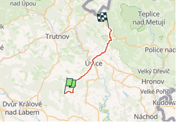
Trail On foot of 21 km to be discovered at Northeast, Královéhradecký kraj, Kohoutov. This trail is proposed by SityTrail - itinéraires balisés pédestres.
Trail created by cz:KČT.
![Trail On foot Kohoutov - [M] Běluňka - Radvanice - Photo 1](https://media.geolcdn.com/t/2048/auto/15e25857-172e-44ca-9603-833cbe6a9a90.jpeg&format=jpg&maxdim=0 "Trail On foot Kohoutov - [M] Běluňka - Radvanice - Photo 1")
![Trail On foot Kohoutov - [M] Běluňka - Radvanice - Photo 2](https://media.geolcdn.com/t/2048/auto/c8e5cae6-7851-41c2-a2ba-82095521c613.jpeg&format=jpg&maxdim=0 "Trail On foot Kohoutov - [M] Běluňka - Radvanice - Photo 2")
![Trail On foot Kohoutov - [M] Běluňka - Radvanice - Photo 3](https://media.geolcdn.com/t/2048/auto/766d2ea0-fbd8-47a3-b779-2e76b7b6a750.jpeg&format=jpg&maxdim=0 "Trail On foot Kohoutov - [M] Běluňka - Radvanice - Photo 3")
![Trail On foot Kohoutov - [M] Běluňka - Radvanice - Photo 4](https://media.geolcdn.com/t/2048/auto/ef42d432-743a-4fbe-b62e-1881336a5707.jpeg&format=jpg&maxdim=0 "Trail On foot Kohoutov - [M] Běluňka - Radvanice - Photo 4")
![Trail On foot Kohoutov - [M] Běluňka - Radvanice - Photo 5](https://media.geolcdn.com/t/2048/auto/48fbf608-6ac0-47f8-94c2-d304076783bb.jpeg&format=jpg&maxdim=0 "Trail On foot Kohoutov - [M] Běluňka - Radvanice - Photo 5")
![Trail On foot Kohoutov - [M] Běluňka - Radvanice - Photo 6](https://media.geolcdn.com/t/2048/auto/f7f92202-ced1-4ea2-a973-5fcf1d97babf.jpeg&format=jpg&maxdim=0 "Trail On foot Kohoutov - [M] Běluňka - Radvanice - Photo 6")
![Trail On foot Kohoutov - [M] Běluňka - Radvanice - Photo 7](https://media.geolcdn.com/t/2048/auto/d3802eb9-9566-4607-af31-d7a093e1145e.jpeg&format=jpg&maxdim=0 "Trail On foot Kohoutov - [M] Běluňka - Radvanice - Photo 7")
![Trail On foot Kohoutov - [M] Běluňka - Radvanice - Photo 8](https://media.geolcdn.com/t/2048/auto/51e74700-37a1-422e-8118-75d3232a226f.jpeg&format=jpg&maxdim=0 "Trail On foot Kohoutov - [M] Běluňka - Radvanice - Photo 8")
![Trail On foot Kohoutov - [M] Běluňka - Radvanice - Photo 9](https://media.geolcdn.com/t/2048/auto/8095e2b5-ae2c-4ac0-8de8-ad600cdfe493.jpeg&format=jpg&maxdim=0 "Trail On foot Kohoutov - [M] Běluňka - Radvanice - Photo 9")
![Trail On foot Kohoutov - [M] Běluňka - Radvanice - Photo 10](https://media.geolcdn.com/t/2048/auto/c7dc4358-cf19-418a-b6e0-16f5f15eb07a.jpeg&format=jpg&maxdim=0 "Trail On foot Kohoutov - [M] Běluňka - Radvanice - Photo 10")
On foot
On foot