


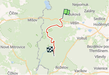

7.9 km | 10.6 km-effort
![Trail On foot Věšín - [Ž] Varta - Třemšín - Photo](https://media.geolcdn.com/t/1900/400/f1b092e8-e85a-4488-b770-d743603f9f8f.jpeg&format=pjpeg&maxdim=2)

Tous les sentiers balisés d’Europe GUIDE+


FREE GPS app for hiking
 SityTrail
IGN / Geographical institutes
SityTrail World
The world is yours!
Trail On foot of 11 km to be discovered at Central Bohemia, Unknown, Věšín. This trail is proposed by SityTrail - itinéraires balisés pédestres.
Trail created by cz:KČT.
![Trail On foot Věšín - [Ž] Varta - Třemšín - Photo 1](https://media.geolcdn.com/t/2048/auto/271b5538-6f8a-4a84-b904-3bb2c350844f.jpeg&format=jpg&maxdim=0 "Trail On foot Věšín - [Ž] Varta - Třemšín - Photo 1")
![Trail On foot Věšín - [Ž] Varta - Třemšín - Photo 2](https://media.geolcdn.com/t/2048/auto/9d520e04-3e14-4cdd-a9d5-2330312084a6.jpeg&format=jpg&maxdim=0 "Trail On foot Věšín - [Ž] Varta - Třemšín - Photo 2")
![Trail On foot Věšín - [Ž] Varta - Třemšín - Photo 3](https://media.geolcdn.com/t/2048/auto/d42ffea0-2a4f-487d-804c-2abe82a115d0.jpeg&format=jpg&maxdim=0 "Trail On foot Věšín - [Ž] Varta - Třemšín - Photo 3")
![Trail On foot Věšín - [Ž] Varta - Třemšín - Photo 4](https://media.geolcdn.com/t/2048/auto/e4f8ab1a-681d-4bf3-8056-1f08151308ff.jpeg&format=jpg&maxdim=0 "Trail On foot Věšín - [Ž] Varta - Třemšín - Photo 4")
![Trail On foot Věšín - [Ž] Varta - Třemšín - Photo 5](https://media.geolcdn.com/t/2048/auto/34eeebef-983f-4f05-9d42-741890d7d34c.jpeg&format=jpg&maxdim=0 "Trail On foot Věšín - [Ž] Varta - Třemšín - Photo 5")
![Trail On foot Věšín - [Ž] Varta - Třemšín - Photo 6](https://media.geolcdn.com/t/2048/auto/30fa0950-62bb-4040-bbed-75329bdebbbe.jpeg&format=jpg&maxdim=0 "Trail On foot Věšín - [Ž] Varta - Třemšín - Photo 6")
![Trail On foot Věšín - [Ž] Varta - Třemšín - Photo 7](https://media.geolcdn.com/t/2048/auto/a94df4fe-8f26-4c17-8e06-96dfb34a5529.jpeg&format=jpg&maxdim=0 "Trail On foot Věšín - [Ž] Varta - Třemšín - Photo 7")
![Trail On foot Věšín - [Ž] Varta - Třemšín - Photo 8](https://media.geolcdn.com/t/2048/auto/617fd336-1e6d-4d31-b841-ac850a32f816.jpeg&format=jpg&maxdim=0 "Trail On foot Věšín - [Ž] Varta - Třemšín - Photo 8")
![Trail On foot Věšín - [Ž] Varta - Třemšín - Photo 9](https://media.geolcdn.com/t/2048/auto/902928c7-cda1-4300-b327-889f5e63e9fd.jpeg&format=jpg&maxdim=0 "Trail On foot Věšín - [Ž] Varta - Třemšín - Photo 9")
![Trail On foot Věšín - [Ž] Varta - Třemšín - Photo 10](https://media.geolcdn.com/t/2048/auto/f1b092e8-e85a-4488-b770-d743603f9f8f.jpeg&format=jpg&maxdim=0 "Trail On foot Věšín - [Ž] Varta - Třemšín - Photo 10")
![Trail On foot Rožmitál pod Třemšínem - [Z] Rožmitál pod Třemšínem - U Padrťských rybníků - Photo](https://media.geolcdn.com/t/375/260/34eeebef-983f-4f05-9d42-741890d7d34c.jpeg&format=jpg&maxdim=2)
On foot