


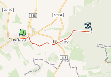

4.6 km | 6.8 km-effort
![Trail On foot Chyňava - [Ž] Chyňava - Pod Chrbinou - Photo](https://media.geolcdn.com/t/1900/400/e837454e-46dc-4204-8650-bd536c13435d.jpeg&format=pjpeg&maxdim=2)

Tous les sentiers balisés d’Europe GUIDE+


FREE GPS app for hiking
 SityTrail
IGN / Geographical institutes
SityTrail World
The world is yours!
Trail On foot of 3.4 km to be discovered at Central Bohemia, Unknown, Chyňava. This trail is proposed by SityTrail - itinéraires balisés pédestres.
Trail created by cz:KČT.
![Trail On foot Chyňava - [Ž] Chyňava - Pod Chrbinou - Photo 1](https://media.geolcdn.com/t/2048/auto/7fd91d35-61b9-472f-8c56-a95c11c23934.jpeg&format=jpg&maxdim=0 "Trail On foot Chyňava - [Ž] Chyňava - Pod Chrbinou - Photo 1")
![Trail On foot Chyňava - [Ž] Chyňava - Pod Chrbinou - Photo 2](https://media.geolcdn.com/t/2048/auto/d2acbe92-1cad-4489-a1dc-d5cb647f260c.jpeg&format=jpg&maxdim=0 "Trail On foot Chyňava - [Ž] Chyňava - Pod Chrbinou - Photo 2")
![Trail On foot Chyňava - [Ž] Chyňava - Pod Chrbinou - Photo 3](https://media.geolcdn.com/t/2048/auto/6148f6ff-c87b-4fa9-8871-be0cfc3a9045.jpeg&format=jpg&maxdim=0 "Trail On foot Chyňava - [Ž] Chyňava - Pod Chrbinou - Photo 3")
![Trail On foot Chyňava - [Ž] Chyňava - Pod Chrbinou - Photo 4](https://media.geolcdn.com/t/2048/auto/9854120b-bbe9-44aa-9f6f-ae7ffdf567a8.jpeg&format=jpg&maxdim=0 "Trail On foot Chyňava - [Ž] Chyňava - Pod Chrbinou - Photo 4")
![Trail On foot Chyňava - [Ž] Chyňava - Pod Chrbinou - Photo 5](https://media.geolcdn.com/t/2048/auto/d448db55-e75e-4071-a677-a8a942cf836d.jpeg&format=jpg&maxdim=0 "Trail On foot Chyňava - [Ž] Chyňava - Pod Chrbinou - Photo 5")
![Trail On foot Chyňava - [Ž] Chyňava - Pod Chrbinou - Photo 6](https://media.geolcdn.com/t/2048/auto/c0351297-7efa-4009-996a-cf8f63123cc9.jpeg&format=jpg&maxdim=0 "Trail On foot Chyňava - [Ž] Chyňava - Pod Chrbinou - Photo 6")
![Trail On foot Chyňava - [Ž] Chyňava - Pod Chrbinou - Photo 7](https://media.geolcdn.com/t/2048/auto/03ee05ec-24be-482d-8e0f-82854aca41e2.jpeg&format=jpg&maxdim=0 "Trail On foot Chyňava - [Ž] Chyňava - Pod Chrbinou - Photo 7")
![Trail On foot Chyňava - [Ž] Chyňava - Pod Chrbinou - Photo 8](https://media.geolcdn.com/t/2048/auto/63473c3c-0a6a-4e0e-97d6-787d1c3a0b6d.jpeg&format=jpg&maxdim=0 "Trail On foot Chyňava - [Ž] Chyňava - Pod Chrbinou - Photo 8")
![Trail On foot Chyňava - [Ž] Chyňava - Pod Chrbinou - Photo 9](https://media.geolcdn.com/t/2048/auto/e837454e-46dc-4204-8650-bd536c13435d.jpeg&format=jpg&maxdim=0 "Trail On foot Chyňava - [Ž] Chyňava - Pod Chrbinou - Photo 9")
![Trail On foot Chyňava - [Ž] Chyňava - Pod Chrbinou - Photo 10](https://media.geolcdn.com/t/2048/auto/76da3ed1-dccf-48ba-af43-45674ee4d939.jpeg&format=jpg&maxdim=0 "Trail On foot Chyňava - [Ž] Chyňava - Pod Chrbinou - Photo 10")
![Trail On foot Hýskov - [Ž] Lhotka u Berouna - Hýskov - Photo](https://media.geolcdn.com/t/375/260/8c27ebc9-efd5-49a5-bdd8-0f93765d8c50.jpeg&format=jpg&maxdim=2)
On foot
![Trail On foot Bratronice - [Z] U Lánské obory - Roučmída - Photo](https://media.geolcdn.com/t/375/260/2c82548d-65b2-4354-bf3f-72bd56202ace.jpeg&format=jpg&maxdim=2)
On foot
![Trail On foot Chyňava - [Ž] Drahelčice - Malé Přílepy - Photo](https://media.geolcdn.com/t/375/260/17914e7a-f42f-4c33-a3bc-0536b262aea8.jpeg&format=jpg&maxdim=2)
On foot
![Trail On foot Chyňava - [Z] Ptice - Lhotka - Photo](https://media.geolcdn.com/t/375/260/c64ec17a-97ca-430f-ae70-6a9a8405b307.jpeg&format=jpg&maxdim=2)
On foot