


8 km | 11.2 km-effort
![Trail On foot Přívrat - [Ž] Zhořský kopec - Pod Lysinou - Photo](https://media.geolcdn.com/t/1900/400/1e28bd45-3668-454f-9395-9932e6e89961.jpeg&format=pjpeg&maxdim=2)

Tous les sentiers balisés d’Europe GUIDE+


FREE GPS app for hiking
 SityTrail
IGN / Geographical institutes
SityTrail World
The world is yours!
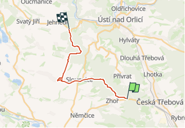
Trail On foot of 15.3 km to be discovered at Northeast, Pardubický kraj, Přívrat. This trail is proposed by SityTrail - itinéraires balisés pédestres.
Trail created by cz:KČT.
![Trail On foot Přívrat - [Ž] Zhořský kopec - Pod Lysinou - Photo 1](https://media.geolcdn.com/t/2048/auto/e1572d7b-c627-4332-81bc-1635f4baefdc.jpeg&format=jpg&maxdim=0 "Trail On foot Přívrat - [Ž] Zhořský kopec - Pod Lysinou - Photo 1")
![Trail On foot Přívrat - [Ž] Zhořský kopec - Pod Lysinou - Photo 2](https://media.geolcdn.com/t/2048/auto/8cda6bb1-0cd3-4b5b-bde2-3b3c08acc007.jpeg&format=jpg&maxdim=0 "Trail On foot Přívrat - [Ž] Zhořský kopec - Pod Lysinou - Photo 2")
![Trail On foot Přívrat - [Ž] Zhořský kopec - Pod Lysinou - Photo 3](https://media.geolcdn.com/t/2048/auto/08d1df52-a692-4a82-8a38-50be9b8422d3.jpeg&format=jpg&maxdim=0 "Trail On foot Přívrat - [Ž] Zhořský kopec - Pod Lysinou - Photo 3")
![Trail On foot Přívrat - [Ž] Zhořský kopec - Pod Lysinou - Photo 4](https://media.geolcdn.com/t/2048/auto/c4fa05f3-d576-4878-ba09-7d4f7bca3734.jpeg&format=jpg&maxdim=0 "Trail On foot Přívrat - [Ž] Zhořský kopec - Pod Lysinou - Photo 4")
![Trail On foot Přívrat - [Ž] Zhořský kopec - Pod Lysinou - Photo 5](https://media.geolcdn.com/t/2048/auto/1aad688d-f162-4a95-b0c2-5a1cbea0ec49.jpeg&format=jpg&maxdim=0 "Trail On foot Přívrat - [Ž] Zhořský kopec - Pod Lysinou - Photo 5")
![Trail On foot Přívrat - [Ž] Zhořský kopec - Pod Lysinou - Photo 6](https://media.geolcdn.com/t/2048/auto/6d623c80-d2e9-4d7b-9468-92244ca730fa.jpeg&format=jpg&maxdim=0 "Trail On foot Přívrat - [Ž] Zhořský kopec - Pod Lysinou - Photo 6")
![Trail On foot Přívrat - [Ž] Zhořský kopec - Pod Lysinou - Photo 7](https://media.geolcdn.com/t/2048/auto/c7e4c37c-d7a4-42bc-a9ea-36dc91d330b6.jpeg&format=jpg&maxdim=0 "Trail On foot Přívrat - [Ž] Zhořský kopec - Pod Lysinou - Photo 7")
![Trail On foot Přívrat - [Ž] Zhořský kopec - Pod Lysinou - Photo 8](https://media.geolcdn.com/t/2048/auto/8dc43ec7-669d-42d8-be25-cb10f87ae9c3.jpeg&format=jpg&maxdim=0 "Trail On foot Přívrat - [Ž] Zhořský kopec - Pod Lysinou - Photo 8")
![Trail On foot Přívrat - [Ž] Zhořský kopec - Pod Lysinou - Photo 9](https://media.geolcdn.com/t/2048/auto/2ac807bd-8b65-437e-9c40-ea08403d58a1.jpeg&format=jpg&maxdim=0 "Trail On foot Přívrat - [Ž] Zhořský kopec - Pod Lysinou - Photo 9")
![Trail On foot Přívrat - [Ž] Zhořský kopec - Pod Lysinou - Photo 10](https://media.geolcdn.com/t/2048/auto/1e28bd45-3668-454f-9395-9932e6e89961.jpeg&format=jpg&maxdim=0 "Trail On foot Přívrat - [Ž] Zhořský kopec - Pod Lysinou - Photo 10")
On foot
On foot
![Trail On foot Česká Třebová - [Ž] Serpentýny - Hory - Photo](https://media.geolcdn.com/t/375/260/bd44ac32-e646-4cc9-8783-18dc2e4b84e1.jpeg&format=jpg&maxdim=2)
On foot
On foot