Trail On foot Třešť - Naučná stezka Špičák - Photo

Naučná stezka Špičák

Tous les sentiers balisés d’Europe GUIDE+

© OpenStreetMap contributors
Length
Length
10.8 km
Max alt
Max alt
741 m
Uphill gradient
Uphill gradient
301 m
Km-Effort
Km-Effort  
14.9 km
Min alt
Min alt
533 m
Downhill gradient
Downhill gradient
302 m
Boucle
Boucle
No
Signpost
Signpost
Creation date :
2025-02-07 01:35:44.97
Updated on :
2025-02-07 01:35:44.97

(0 Reviews)

On foot
On foot
3h22
Difficulty : Easy

Scan this QR Code to open this trail in the SityTrail application

FREE GPS app for hiking

Logo SityTrail SityTrail

IGN / Geographical institutes

Download SityTrail from the App Store Download SityTrail from Google Play

Logo SityTrail SityTrail World

The world is yours!

Download SityTrail from the App Store Download SityTrail from Google Play Download SityTrail on Huawei AppGallery

About

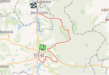
Trail On foot of 10.8 km to be discovered at Southeast, Kraj Vysočina, Třešť. This trail is proposed by SityTrail - itinéraires balisés pédestres.

Description

Trail created by cz:KČT.

Elevation profile

Photos

Positioning

Country:
Czech Republic
Region :
Southeast
Department/Province :
Kraj Vysočina
Municipality :
Třešť
Location:
Unknown
Start:(UTM)
535117 ; 5460056 (33U) N.

Trails nearby

Trail On foot Rantířov - Pěší trasy Stříbrného pomezí - Photo
On foot
GUIDE+

On foot

Easy
Rantířov, Southeast, Kraj Vysočina, Czech Republic
4.7 km | 6 km-effort
1h 21min
No
Trail On foot Chlístov - Naučná stezka Po mlýnech - Photo
On foot
GUIDE+

On foot

Difficult
Chlístov, Southeast, Kraj Vysočina, Czech Republic
26 km | 32 km-effort
7h 17min
No
Trail On foot Jihlava - Hornická NS - Photo
On foot
GUIDE+

On foot

Easy
Jihlava, Southeast, Kraj Vysočina, Czech Republic
5.7 km | 8.1 km-effort
1h 49min
No
Trail On foot Kostelní Myslová - Naučná stezka F. M. Nágla - Photo
On foot
GUIDE+

On foot

Easy
Kostelní Myslová, Southeast, Kraj Vysočina, Czech Republic
3.5 km | 4.4 km-effort
1h 0min
Yes
Trail On foot Telč - NS Otokara Březiny - Photo
On foot
GUIDE+

On foot

Medium
Telč, Southeast, Kraj Vysočina, Czech Republic
19.3 km | 25 km-effort
5h 37min
No
Trail On foot Heřmaneč - NS valdenské a české reformace - Photo
On foot
GUIDE+

On foot

Easy
Heřmaneč, Southwest, Jihočeský kraj, Czech Republic
12.2 km | 16 km-effort
3h 37min
No
Trail On foot Radonín - Lesní naučná stezka - Photo
On foot
GUIDE+

On foot

Easy
Radonín, Southeast, Kraj Vysočina, Czech Republic
6.2 km | 7.8 km-effort
1h 45min
Yes
Trail On foot Pelhřimov - [Č] Pelhřimov - Nový Rychnov - Photo
On foot
GUIDE+

On foot

Easy
Pelhřimov, Southeast, Kraj Vysočina, Czech Republic
14.6 km | 19.9 km-effort
4h 31min
No
Trail On foot Dačice - [Ž] Velký Pěčín - Nad Strouhou - Photo
On foot
GUIDE+

On foot

Easy
Dačice, Southwest, Jihočeský kraj, Czech Republic
8.3 km | 10.9 km-effort
2h 28min
No


Close
My subscriptions