


5.7 km | 7.9 km-effort
![Trail On foot Ždánice - [Ž] Černčín - Bučovice - Photo](https://media.geolcdn.com/t/1900/400/0e8a5bf5-67a6-4aaf-a695-d3a2c91aad48.jpeg&format=pjpeg&maxdim=2)

Tous les sentiers balisés d’Europe GUIDE+


FREE GPS app for hiking
 SityTrail
IGN / Geographical institutes
SityTrail World
The world is yours!
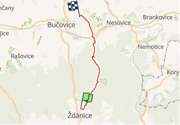
Trail On foot of 12.1 km to be discovered at Southeast, Jihomoravský kraj, Ždánice. This trail is proposed by SityTrail - itinéraires balisés pédestres.
Trail created by cz:KČT.
![Trail On foot Ždánice - [Ž] Černčín - Bučovice - Photo 1](https://media.geolcdn.com/t/2048/auto/94c10ba1-8d85-4880-bbde-603c4dea1554.jpeg&format=jpg&maxdim=0 "Trail On foot Ždánice - [Ž] Černčín - Bučovice - Photo 1")
![Trail On foot Ždánice - [Ž] Černčín - Bučovice - Photo 2](https://media.geolcdn.com/t/2048/auto/df9be933-87c3-4ceb-89fc-83efff5494a2.jpeg&format=jpg&maxdim=0 "Trail On foot Ždánice - [Ž] Černčín - Bučovice - Photo 2")
![Trail On foot Ždánice - [Ž] Černčín - Bučovice - Photo 3](https://media.geolcdn.com/t/2048/auto/aa7e078e-b72c-4573-9c76-1877eca0dc53.jpeg&format=jpg&maxdim=0 "Trail On foot Ždánice - [Ž] Černčín - Bučovice - Photo 3")
![Trail On foot Ždánice - [Ž] Černčín - Bučovice - Photo 4](https://media.geolcdn.com/t/2048/auto/d13e0f9b-0034-410d-9fa4-ff218220b19f.jpeg&format=jpg&maxdim=0 "Trail On foot Ždánice - [Ž] Černčín - Bučovice - Photo 4")
![Trail On foot Ždánice - [Ž] Černčín - Bučovice - Photo 5](https://media.geolcdn.com/t/2048/auto/f6b0eb85-57ab-4855-8a3a-fc6574b2bb74.jpeg&format=jpg&maxdim=0 "Trail On foot Ždánice - [Ž] Černčín - Bučovice - Photo 5")
![Trail On foot Ždánice - [Ž] Černčín - Bučovice - Photo 6](https://media.geolcdn.com/t/2048/auto/fe14e903-64e2-407a-ba13-9c9aaf13d522.jpeg&format=jpg&maxdim=0 "Trail On foot Ždánice - [Ž] Černčín - Bučovice - Photo 6")
![Trail On foot Ždánice - [Ž] Černčín - Bučovice - Photo 7](https://media.geolcdn.com/t/2048/auto/7ad681d4-ab0e-458b-a037-5bd981e2d2c9.jpeg&format=jpg&maxdim=0 "Trail On foot Ždánice - [Ž] Černčín - Bučovice - Photo 7")
![Trail On foot Ždánice - [Ž] Černčín - Bučovice - Photo 8](https://media.geolcdn.com/t/2048/auto/2aaa69a0-c0cf-43d6-9513-053458c36651.jpeg&format=jpg&maxdim=0 "Trail On foot Ždánice - [Ž] Černčín - Bučovice - Photo 8")
![Trail On foot Ždánice - [Ž] Černčín - Bučovice - Photo 9](https://media.geolcdn.com/t/2048/auto/a5084141-42d1-494c-8141-1a1d0f2df736.jpeg&format=jpg&maxdim=0 "Trail On foot Ždánice - [Ž] Černčín - Bučovice - Photo 9")
![Trail On foot Ždánice - [Ž] Černčín - Bučovice - Photo 10](https://media.geolcdn.com/t/2048/auto/0e8a5bf5-67a6-4aaf-a695-d3a2c91aad48.jpeg&format=jpg&maxdim=0 "Trail On foot Ždánice - [Ž] Černčín - Bučovice - Photo 10")
On foot