![](/images/other/stat-length.png)
![Trail On foot Svoboda nad Úpou - CZ-4228 - Photo](https://media.geolcdn.com/t/1900/400/29e51357-4907-46d3-8b6c-8defb7cf95a1.jpeg&format=pjpeg&maxdim=2)
CZ-4228
SityTrail - itinéraires balisés pédestres
Tous les sentiers balisés d’Europe GUIDE+
![Length](/images/other/stat-length.png)
Length
5.3 km
![Max alt](https://static1.geolcdn.com/siteimages/upload/files/1508320355ic_sort_altitude_max_24dp.png)
Max alt
797 m
![Uphill gradient](https://static1.geolcdn.com/siteimages/upload/files/1508320355ic_sort_den_pos_24dp.png)
Uphill gradient
331 m
![Km-Effort](/images/other/stat-length.png)
Km-Effort
8.8 km
![Min alt](https://static1.geolcdn.com/siteimages/upload/files/1508320355ic_sort_altitude_min_24dp.png)
Min alt
512 m
![Downhill gradient](https://static1.geolcdn.com/siteimages/upload/files/1508320355ic_sort_den_neg_24dp.png)
Downhill gradient
54 m
![Boucle](https://static1.geolcdn.com/siteimages/upload/files/16400158638029165_repeat_loop_refresh_sync_direction_icon.png)
Boucle
No
Signpost
Creation date :
2025-02-07 01:04:47.99
Updated on :
2025-02-07 01:04:47.99
![On foot](https://static1.geolcdn.com/sitytour/trail-icons/100.png)
2h00
Difficulty : Easy
![Scan this QR Code to open this trail in the SityTrail application](https://capi.geolives.com/qq0zvz2zws4bq2lad0pu/sitytour/trails/4344370/qr.png?size=200)
FREE GPS app for hiking
About
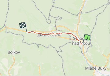
Trail On foot of 5.3 km to be discovered at Northeast, Královéhradecký kraj, Svoboda nad Úpou. This trail is proposed by SityTrail - itinéraires balisés pédestres.
Description
Trail created by cz:KČT.
[Z] Hoffmannova bouda - Svoboda nad Úpou
Positioning
Country:
Czech Republic
Region :
Northeast
Department/Province :
Královéhradecký kraj
Municipality :
Svoboda nad Úpou
Location:
Unknown
Start:(Dec)
Start:(UTM)
557899 ; 5608289 (33U) N.
Comments
Trails nearby
![Trail On foot Horní Maršov - [Ž] Horní Maršov - Modrokamenná bouda - Photo](https://media.geolcdn.com/t/375/260/44f7fc1a-efca-4195-b366-065d808a6118.jpeg&format=jpg&maxdim=2)
![On foot On foot](https://static1.geolcdn.com/sitytour/trail-icons/100.png)
[Ž] Horní Maršov - Modrokamenná bouda
On foot
Easy
Horní Maršov,
Northeast,
Královéhradecký kraj,
Czech Republic
![](/images/other/stat-length.png)
4.7 km | 9.3 km-effort
2h 6min
![](https://static1.geolcdn.com/siteimages/upload/files/16400158638029165_repeat_loop_refresh_sync_direction_icon.png)
No
![Trail On foot Horní Maršov - [Ž] Horní Maršov - Kutná - Photo](https://media.geolcdn.com/t/375/260/ea676acc-d202-406f-b8f0-aa2f09ab6f09.jpeg&format=jpg&maxdim=2)
![On foot On foot](https://static1.geolcdn.com/sitytour/trail-icons/100.png)
[Ž] Horní Maršov - Kutná
On foot
Easy
Horní Maršov,
Northeast,
Královéhradecký kraj,
Czech Republic
![](/images/other/stat-length.png)
4 km | 8.3 km-effort
1h 53min
![](https://static1.geolcdn.com/siteimages/upload/files/16400158638029165_repeat_loop_refresh_sync_direction_icon.png)
No
![Trail On foot Janské Lázně - [M] Janské Lázně - Pod Starou horou - Photo](https://media.geolcdn.com/t/375/260/65cc2a07-fb0a-4fcc-b685-a366c73b9bf2.jpeg&format=jpg&maxdim=2)
![On foot On foot](https://static1.geolcdn.com/sitytour/trail-icons/100.png)
[M] Janské Lázně - Pod Starou horou
On foot
Easy
Janské Lázně,
Northeast,
Královéhradecký kraj,
Czech Republic
![](/images/other/stat-length.png)
7 km | 12.1 km-effort
2h 44min
![](https://static1.geolcdn.com/siteimages/upload/files/16400158638029165_repeat_loop_refresh_sync_direction_icon.png)
No
![Trail On foot Janské Lázně - CZ-1816 - Photo](https://media.geolcdn.com/t/375/260/65cc2a07-fb0a-4fcc-b685-a366c73b9bf2.jpeg&format=jpg&maxdim=2)
![On foot On foot](https://static1.geolcdn.com/sitytour/trail-icons/100.png)
CZ-1816
On foot
Easy
Janské Lázně,
Northeast,
Královéhradecký kraj,
Czech Republic
![](/images/other/stat-length.png)
4.7 km | 8.7 km-effort
1h 58min
![](https://static1.geolcdn.com/siteimages/upload/files/16400158638029165_repeat_loop_refresh_sync_direction_icon.png)
No
![Trail On foot Horní Maršov - [Z] U Thamových bud - Nad Pražačkou - H. Maršov - Photo](https://media.geolcdn.com/t/375/260/468ba62a-e3de-4995-8c92-00e6c534980d.jpeg&format=jpg&maxdim=2)
![On foot On foot](https://static1.geolcdn.com/sitytour/trail-icons/100.png)
[Z] U Thamových bud - Nad Pražačkou - H. Maršov
On foot
Easy
Horní Maršov,
Northeast,
Královéhradecký kraj,
Czech Republic
![](/images/other/stat-length.png)
4.4 km | 7 km-effort
1h 35min
![](https://static1.geolcdn.com/siteimages/upload/files/16400158638029165_repeat_loop_refresh_sync_direction_icon.png)
No