


8.4 km | 10.4 km-effort
![Trail On foot Kokořín - [Č] Jestřebice - Klemperka - Photo](https://media.geolcdn.com/t/1900/400/072acdae-ecee-46f8-9db4-3714e691d52d.jpeg&format=pjpeg&maxdim=2)

Tous les sentiers balisés d’Europe GUIDE+


FREE GPS app for hiking
 SityTrail
IGN / Geographical institutes
SityTrail World
The world is yours!
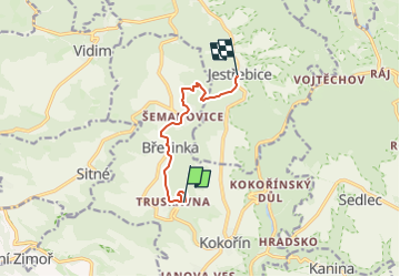
Trail On foot of 6.2 km to be discovered at Central Bohemia, Unknown, Kokořín. This trail is proposed by SityTrail - itinéraires balisés pédestres.
Trail created by cz:KČT.
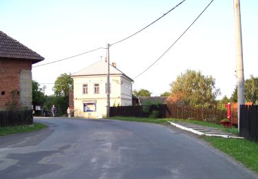
![Trail On foot Kokořín - [Č] Jestřebice - Klemperka - Photo 1](https://media.geolcdn.com/t/2048/auto/21811497-cffa-43b0-93fe-dd970d14e6aa.jpeg&format=jpg&maxdim=0 "Trail On foot Kokořín - [Č] Jestřebice - Klemperka - Photo 1")
![Trail On foot Kokořín - [Č] Jestřebice - Klemperka - Photo 2](https://media.geolcdn.com/t/2048/auto/5bff6bb8-ef04-437a-9451-04fddf0ea369.jpeg&format=jpg&maxdim=0 "Trail On foot Kokořín - [Č] Jestřebice - Klemperka - Photo 2")
![Trail On foot Kokořín - [Č] Jestřebice - Klemperka - Photo 3](https://media.geolcdn.com/t/2048/auto/328d300c-57b2-47e1-97c9-60960bf5a21a.jpeg&format=jpg&maxdim=0 "Trail On foot Kokořín - [Č] Jestřebice - Klemperka - Photo 3")
![Trail On foot Kokořín - [Č] Jestřebice - Klemperka - Photo 4](https://media.geolcdn.com/t/2048/auto/93c1595d-f161-41c0-a32d-b8f37e1af940.jpeg&format=jpg&maxdim=0 "Trail On foot Kokořín - [Č] Jestřebice - Klemperka - Photo 4")
![Trail On foot Kokořín - [Č] Jestřebice - Klemperka - Photo 5](https://media.geolcdn.com/t/2048/auto/e9f8f440-464b-44fc-af17-fd3d668b374c.jpeg&format=jpg&maxdim=0 "Trail On foot Kokořín - [Č] Jestřebice - Klemperka - Photo 5")
![Trail On foot Kokořín - [Č] Jestřebice - Klemperka - Photo 6](https://media.geolcdn.com/t/2048/auto/745ba888-4258-4782-8a12-beca3d90b8dd.jpeg&format=jpg&maxdim=0 "Trail On foot Kokořín - [Č] Jestřebice - Klemperka - Photo 6")
![Trail On foot Kokořín - [Č] Jestřebice - Klemperka - Photo 7](https://media.geolcdn.com/t/2048/auto/c65e2010-c568-40bb-a7a1-a2211824dd82.jpeg&format=jpg&maxdim=0 "Trail On foot Kokořín - [Č] Jestřebice - Klemperka - Photo 7")
![Trail On foot Kokořín - [Č] Jestřebice - Klemperka - Photo 8](https://media.geolcdn.com/t/2048/auto/3fc9b662-bebc-4e25-8600-9933d2b4808a.jpeg&format=jpg&maxdim=0 "Trail On foot Kokořín - [Č] Jestřebice - Klemperka - Photo 8")
![Trail On foot Kokořín - [Č] Jestřebice - Klemperka - Photo 9](https://media.geolcdn.com/t/2048/auto/655a8076-595e-401e-9469-829acc7c8186.jpeg&format=jpg&maxdim=0 "Trail On foot Kokořín - [Č] Jestřebice - Klemperka - Photo 9")
![Trail On foot Kokořín - [Č] Jestřebice - Klemperka - Photo 10](https://media.geolcdn.com/t/2048/auto/072acdae-ecee-46f8-9db4-3714e691d52d.jpeg&format=jpg&maxdim=0 "Trail On foot Kokořín - [Č] Jestřebice - Klemperka - Photo 10")
![Trail On foot Vysoká - [Ž] Harasov - Chloumek - Photo](https://media.geolcdn.com/t/375/260/bc275f67-78cb-4ea7-af7b-1cfdb0fea829.jpeg&format=jpg&maxdim=2)
On foot
On foot
![Trail On foot Želízy - [M] Kokořín - Zimořský důl - Photo](https://media.geolcdn.com/t/375/260/04ffd1a5-afe9-4e85-be18-0b7b38d70abe.jpeg&format=jpg&maxdim=2)
On foot
![Trail On foot Dobřeň - [Z] Velký Mšenský okruh - Photo](https://media.geolcdn.com/t/375/260/9e1e21cd-073d-4888-8c74-b7e69c1fa5e2.jpeg&format=jpg&maxdim=2)
On foot