


3.8 km | 5.6 km-effort
![Trail On foot Hořice na Šumavě - [Ž] Muckov - Hořice na Šumavě - Photo](https://media.geolcdn.com/t/1900/400/bf242f83-f54e-415b-9f70-5c4528c11631.jpeg&format=pjpeg&maxdim=2)

Tous les sentiers balisés d’Europe GUIDE+


FREE GPS app for hiking
 SityTrail
IGN / Geographical institutes
SityTrail World
The world is yours!
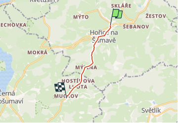
Trail On foot of 4.8 km to be discovered at Southwest, Jihočeský kraj, Hořice na Šumavě. This trail is proposed by SityTrail - itinéraires balisés pédestres.
Trail created by cz:KČT.
![Trail On foot Hořice na Šumavě - [Ž] Muckov - Hořice na Šumavě - Photo 1](https://media.geolcdn.com/t/2048/auto/7dacba60-bcab-46f0-8361-279a55958832.jpeg&format=jpg&maxdim=0 "Trail On foot Hořice na Šumavě - [Ž] Muckov - Hořice na Šumavě - Photo 1")
![Trail On foot Hořice na Šumavě - [Ž] Muckov - Hořice na Šumavě - Photo 2](https://media.geolcdn.com/t/2048/auto/8feed3f6-67fc-4488-a1fa-f863e9641193.jpeg&format=jpg&maxdim=0 "Trail On foot Hořice na Šumavě - [Ž] Muckov - Hořice na Šumavě - Photo 2")
![Trail On foot Hořice na Šumavě - [Ž] Muckov - Hořice na Šumavě - Photo 3](https://media.geolcdn.com/t/2048/auto/65c34f2a-9d2d-4933-8875-eab731e54dfe.jpeg&format=jpg&maxdim=0 "Trail On foot Hořice na Šumavě - [Ž] Muckov - Hořice na Šumavě - Photo 3")
![Trail On foot Hořice na Šumavě - [Ž] Muckov - Hořice na Šumavě - Photo 4](https://media.geolcdn.com/t/2048/auto/1036ea08-33f9-4af1-a637-5b8ad1576104.jpeg&format=jpg&maxdim=0 "Trail On foot Hořice na Šumavě - [Ž] Muckov - Hořice na Šumavě - Photo 4")
![Trail On foot Hořice na Šumavě - [Ž] Muckov - Hořice na Šumavě - Photo 5](https://media.geolcdn.com/t/2048/auto/ab227b26-1f83-4c13-9ff6-925526f63d6a.jpeg&format=jpg&maxdim=0 "Trail On foot Hořice na Šumavě - [Ž] Muckov - Hořice na Šumavě - Photo 5")
![Trail On foot Hořice na Šumavě - [Ž] Muckov - Hořice na Šumavě - Photo 6](https://media.geolcdn.com/t/2048/auto/74c94729-5a11-43db-8f13-f80e64b59b5f.jpeg&format=jpg&maxdim=0 "Trail On foot Hořice na Šumavě - [Ž] Muckov - Hořice na Šumavě - Photo 6")
![Trail On foot Hořice na Šumavě - [Ž] Muckov - Hořice na Šumavě - Photo 7](https://media.geolcdn.com/t/2048/auto/fc28c4c5-1845-4d82-adb4-fb268d337283.jpeg&format=jpg&maxdim=0 "Trail On foot Hořice na Šumavě - [Ž] Muckov - Hořice na Šumavě - Photo 7")
![Trail On foot Hořice na Šumavě - [Ž] Muckov - Hořice na Šumavě - Photo 8](https://media.geolcdn.com/t/2048/auto/d4241133-4ee6-4beb-b704-36e1c2fe2832.jpeg&format=jpg&maxdim=0 "Trail On foot Hořice na Šumavě - [Ž] Muckov - Hořice na Šumavě - Photo 8")
![Trail On foot Hořice na Šumavě - [Ž] Muckov - Hořice na Šumavě - Photo 9](https://media.geolcdn.com/t/2048/auto/bf242f83-f54e-415b-9f70-5c4528c11631.jpeg&format=jpg&maxdim=0 "Trail On foot Hořice na Šumavě - [Ž] Muckov - Hořice na Šumavě - Photo 9")
![Trail On foot Hořice na Šumavě - [Ž] Muckov - Hořice na Šumavě - Photo 10](https://media.geolcdn.com/t/2048/auto/c1f3751e-1cda-4b08-8aab-bccb9948b5f5.jpeg&format=jpg&maxdim=0 "Trail On foot Hořice na Šumavě - [Ž] Muckov - Hořice na Šumavě - Photo 10")
On foot
On foot
![Trail On foot Loučovice - [Ž] Kapličky - Mnichovice - Photo](https://media.geolcdn.com/t/375/260/1772f7d3-364c-4f12-bb68-2d31ffa4b776.jpeg&format=jpg&maxdim=2)
On foot
![Trail On foot Loučovice - [Ž] Vyšší Brod - Loučovice - Photo](https://media.geolcdn.com/t/375/260/81249ce9-5aee-4e68-9458-f6a14a4fc319.jpeg&format=jpg&maxdim=2)
On foot
On foot
![Trail On foot Vrábče - [Ž] U Habří - Vrábče - Photo](https://media.geolcdn.com/t/375/260/b844f148-6ba9-443e-8962-0fcc37a4d7b1.jpeg&format=jpg&maxdim=2)
On foot
![Trail On foot Dolní Třebonín - [Ž] Dolní Svince - Štěkře - Photo](https://media.geolcdn.com/t/375/260/64839e16-74c1-4eac-9fd3-78a9e4f0179c.jpeg&format=jpg&maxdim=2)
On foot
On foot
![Trail On foot Český Krumlov - [Ž] Český Krumlov - Vyšný - Photo](https://media.geolcdn.com/t/375/260/523ff9b3-b985-40a2-95ef-c41c2b716efa.jpeg&format=jpg&maxdim=2)
On foot