


12.9 km | 17.2 km-effort
![Trail On foot Točník - [Z] Točník - Skryje - Photo](https://media.geolcdn.com/t/1900/400/c112c8a5-8274-4fdb-8361-8c912e831baa.jpeg&format=pjpeg&maxdim=2)

Tous les sentiers balisés d’Europe GUIDE+


FREE GPS app for hiking
 SityTrail
IGN / Geographical institutes
SityTrail World
The world is yours!
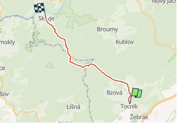
Trail On foot of 14.6 km to be discovered at Central Bohemia, Unknown, Točník. This trail is proposed by SityTrail - itinéraires balisés pédestres.
Trail created by cz:KČT.
![Trail On foot Točník - [Z] Točník - Skryje - Photo 1](https://media.geolcdn.com/t/2048/auto/3258e93b-28f6-415a-a6ff-82852e5b8f74.jpeg&format=jpg&maxdim=0 "Trail On foot Točník - [Z] Točník - Skryje - Photo 1")
![Trail On foot Točník - [Z] Točník - Skryje - Photo 2](https://media.geolcdn.com/t/2048/auto/06a7c82b-b8a4-4aaf-971a-2297bf09dbb5.jpeg&format=jpg&maxdim=0 "Trail On foot Točník - [Z] Točník - Skryje - Photo 2")
![Trail On foot Točník - [Z] Točník - Skryje - Photo 3](https://media.geolcdn.com/t/2048/auto/798de58d-2d06-4a7e-803d-7ed34b84e146.jpeg&format=jpg&maxdim=0 "Trail On foot Točník - [Z] Točník - Skryje - Photo 3")
![Trail On foot Točník - [Z] Točník - Skryje - Photo 4](https://media.geolcdn.com/t/2048/auto/4a6ad350-5e1c-41f5-980e-943a5961d9bc.jpeg&format=jpg&maxdim=0 "Trail On foot Točník - [Z] Točník - Skryje - Photo 4")
![Trail On foot Točník - [Z] Točník - Skryje - Photo 5](https://media.geolcdn.com/t/2048/auto/95bbce3c-f48c-4a0b-9bc6-bd3b3ddb8999.jpeg&format=jpg&maxdim=0 "Trail On foot Točník - [Z] Točník - Skryje - Photo 5")
![Trail On foot Točník - [Z] Točník - Skryje - Photo 6](https://media.geolcdn.com/t/2048/auto/13f27686-d5f9-4635-a0cf-96134d0d645f.jpeg&format=jpg&maxdim=0 "Trail On foot Točník - [Z] Točník - Skryje - Photo 6")
![Trail On foot Točník - [Z] Točník - Skryje - Photo 7](https://media.geolcdn.com/t/2048/auto/2149c2a2-8891-4eac-ac5d-3458b5b0977d.jpeg&format=jpg&maxdim=0 "Trail On foot Točník - [Z] Točník - Skryje - Photo 7")
![Trail On foot Točník - [Z] Točník - Skryje - Photo 8](https://media.geolcdn.com/t/2048/auto/ff98cd51-a854-4799-a744-52486764ed46.jpeg&format=jpg&maxdim=0 "Trail On foot Točník - [Z] Točník - Skryje - Photo 8")
![Trail On foot Točník - [Z] Točník - Skryje - Photo 9](https://media.geolcdn.com/t/2048/auto/c112c8a5-8274-4fdb-8361-8c912e831baa.jpeg&format=jpg&maxdim=0 "Trail On foot Točník - [Z] Točník - Skryje - Photo 9")
![Trail On foot Točník - [Z] Točník - Skryje - Photo 10](https://media.geolcdn.com/t/2048/auto/ffa319d3-385a-4c48-9acb-fb1d3d5fa219.jpeg&format=jpg&maxdim=0 "Trail On foot Točník - [Z] Točník - Skryje - Photo 10")
![Trail On foot Zdice - [Z] Karlova Ves - Na Hřebeni - Photo](https://media.geolcdn.com/t/375/260/84a9eb58-c0e8-4239-982e-643287d19237.jpeg&format=jpg&maxdim=2)
On foot
![Trail On foot Březová - [Ž] Točník - Veliz - Točník - okružní - Photo](https://media.geolcdn.com/t/375/260/d7395d73-c9fd-4468-8482-1f38139bc8d9.jpeg&format=jpg&maxdim=2)
On foot