


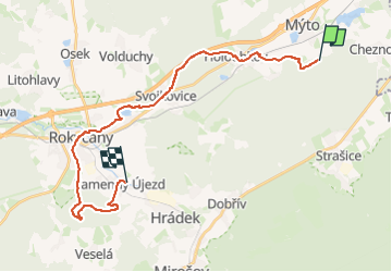

7.8 km | 10.2 km-effort
![Trail On foot Mýto - [M] Kamenný Újezd - Pod lesem u Mýta - Photo](https://media.geolcdn.com/t/1900/400/182a32a0-41b9-4a36-a0c6-da1dec4ffa18.jpeg&format=pjpeg&maxdim=2)

Tous les sentiers balisés d’Europe GUIDE+


FREE GPS app for hiking
 SityTrail
IGN / Geographical institutes
SityTrail World
The world is yours!
Trail On foot of 24 km to be discovered at Southwest, Plzeňský kraj, Mýto. This trail is proposed by SityTrail - itinéraires balisés pédestres.
Trail created by cz:KČT.
![Trail On foot Mýto - [M] Kamenný Újezd - Pod lesem u Mýta - Photo 1](https://media.geolcdn.com/t/2048/auto/acfae513-f4d9-4c8d-bdd4-1c46a64d7823.jpeg&format=jpg&maxdim=0 "Trail On foot Mýto - [M] Kamenný Újezd - Pod lesem u Mýta - Photo 1")
![Trail On foot Mýto - [M] Kamenný Újezd - Pod lesem u Mýta - Photo 2](https://media.geolcdn.com/t/2048/auto/1e2db121-4a50-4024-b00a-bc3ef69fa9f8.jpeg&format=jpg&maxdim=0 "Trail On foot Mýto - [M] Kamenný Újezd - Pod lesem u Mýta - Photo 2")
![Trail On foot Mýto - [M] Kamenný Újezd - Pod lesem u Mýta - Photo 3](https://media.geolcdn.com/t/2048/auto/a2aa5360-1f5c-4173-978e-8699676e83fb.jpeg&format=jpg&maxdim=0 "Trail On foot Mýto - [M] Kamenný Újezd - Pod lesem u Mýta - Photo 3")
![Trail On foot Mýto - [M] Kamenný Újezd - Pod lesem u Mýta - Photo 4](https://media.geolcdn.com/t/2048/auto/da402af9-843b-40eb-bb00-61d628845821.jpeg&format=jpg&maxdim=0 "Trail On foot Mýto - [M] Kamenný Újezd - Pod lesem u Mýta - Photo 4")
![Trail On foot Mýto - [M] Kamenný Újezd - Pod lesem u Mýta - Photo 5](https://media.geolcdn.com/t/2048/auto/634613eb-b164-4f9a-a4c7-75afb3d43658.jpeg&format=jpg&maxdim=0 "Trail On foot Mýto - [M] Kamenný Újezd - Pod lesem u Mýta - Photo 5")
![Trail On foot Mýto - [M] Kamenný Újezd - Pod lesem u Mýta - Photo 6](https://media.geolcdn.com/t/2048/auto/192e5f99-7b62-47bf-8440-2c1bb7e37be7.jpeg&format=jpg&maxdim=0 "Trail On foot Mýto - [M] Kamenný Újezd - Pod lesem u Mýta - Photo 6")
![Trail On foot Mýto - [M] Kamenný Újezd - Pod lesem u Mýta - Photo 7](https://media.geolcdn.com/t/2048/auto/597eab6f-b921-4e29-9848-55b6839acb9b.jpeg&format=jpg&maxdim=0 "Trail On foot Mýto - [M] Kamenný Újezd - Pod lesem u Mýta - Photo 7")
![Trail On foot Mýto - [M] Kamenný Újezd - Pod lesem u Mýta - Photo 8](https://media.geolcdn.com/t/2048/auto/e5cffe2c-8e50-4f40-855f-ba626dbb8976.jpeg&format=jpg&maxdim=0 "Trail On foot Mýto - [M] Kamenný Újezd - Pod lesem u Mýta - Photo 8")
![Trail On foot Mýto - [M] Kamenný Újezd - Pod lesem u Mýta - Photo 9](https://media.geolcdn.com/t/2048/auto/7000e584-ccc1-474e-8e0c-1e711d76c079.jpeg&format=jpg&maxdim=0 "Trail On foot Mýto - [M] Kamenný Újezd - Pod lesem u Mýta - Photo 9")
![Trail On foot Mýto - [M] Kamenný Újezd - Pod lesem u Mýta - Photo 10](https://media.geolcdn.com/t/2048/auto/182a32a0-41b9-4a36-a0c6-da1dec4ffa18.jpeg&format=jpg&maxdim=0 "Trail On foot Mýto - [M] Kamenný Újezd - Pod lesem u Mýta - Photo 10")
On foot
![Trail On foot Újezd - [Ž] Kařízek - Týček - Photo](https://media.geolcdn.com/t/375/260/e4e16ae0-b46d-45a5-803c-c3b46f9d7a1e.jpeg&format=jpg&maxdim=2)
On foot
![Trail On foot Mýto - [M] Mýto-Zbiroh - Photo](https://media.geolcdn.com/t/375/260/26552159-6e94-4452-8995-a97941c253c2.jpeg&format=jpg&maxdim=2)
On foot
![Trail On foot Újezd - [Č] Strašice-Kařízek - Photo](https://media.geolcdn.com/t/375/260/29a7adf3-4cb7-4d97-ae5b-a34c7c58c20b.jpeg&format=jpg&maxdim=2)
On foot