


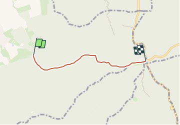

4.3 km | 5.5 km-effort
![Trail On foot Roštín - [Ž] Roštínská kaple - Bunč - Photo](https://media.geolcdn.com/t/1900/400/4eacabd4-450a-4e5f-93af-313922c3e823.jpeg&format=pjpeg&maxdim=2)

Tous les sentiers balisés d’Europe GUIDE+


FREE GPS app for hiking
 SityTrail
IGN / Geographical institutes
SityTrail World
The world is yours!
Trail On foot of 3.3 km to be discovered at Central Moravia, Zlínský kraj, Roštín. This trail is proposed by SityTrail - itinéraires balisés pédestres.
Trail created by cz:KČT.
![Trail On foot Roštín - [Ž] Roštínská kaple - Bunč - Photo 1](https://media.geolcdn.com/t/2048/auto/fc1dd994-8dec-429d-919a-bd770c9c4553.jpeg&format=jpg&maxdim=0 "Trail On foot Roštín - [Ž] Roštínská kaple - Bunč - Photo 1")
![Trail On foot Roštín - [Ž] Roštínská kaple - Bunč - Photo 2](https://media.geolcdn.com/t/2048/auto/2b5ea5f2-30b6-4025-8d83-274583f425e7.jpeg&format=jpg&maxdim=0 "Trail On foot Roštín - [Ž] Roštínská kaple - Bunč - Photo 2")
![Trail On foot Roštín - [Ž] Roštínská kaple - Bunč - Photo 3](https://media.geolcdn.com/t/2048/auto/39ad7a1a-9e22-4249-b2f4-2f32f4325a0b.jpeg&format=jpg&maxdim=0 "Trail On foot Roštín - [Ž] Roštínská kaple - Bunč - Photo 3")
![Trail On foot Roštín - [Ž] Roštínská kaple - Bunč - Photo 4](https://media.geolcdn.com/t/2048/auto/3938dcab-99b6-4c4f-926f-1abf88d68b88.jpeg&format=jpg&maxdim=0 "Trail On foot Roštín - [Ž] Roštínská kaple - Bunč - Photo 4")
![Trail On foot Roštín - [Ž] Roštínská kaple - Bunč - Photo 5](https://media.geolcdn.com/t/2048/auto/fed85502-e918-4c45-8200-d19d6fe5e7e3.jpeg&format=jpg&maxdim=0 "Trail On foot Roštín - [Ž] Roštínská kaple - Bunč - Photo 5")
![Trail On foot Roštín - [Ž] Roštínská kaple - Bunč - Photo 6](https://media.geolcdn.com/t/2048/auto/b6e546ce-0950-4d9d-9b5a-a49a4cf38f73.jpeg&format=jpg&maxdim=0 "Trail On foot Roštín - [Ž] Roštínská kaple - Bunč - Photo 6")
![Trail On foot Roštín - [Ž] Roštínská kaple - Bunč - Photo 7](https://media.geolcdn.com/t/2048/auto/4ccb0681-083f-4c29-899d-4dbe31849d83.jpeg&format=jpg&maxdim=0 "Trail On foot Roštín - [Ž] Roštínská kaple - Bunč - Photo 7")
![Trail On foot Roštín - [Ž] Roštínská kaple - Bunč - Photo 8](https://media.geolcdn.com/t/2048/auto/52dea629-0f0b-4b70-83df-c000d7d33355.jpeg&format=jpg&maxdim=0 "Trail On foot Roštín - [Ž] Roštínská kaple - Bunč - Photo 8")
![Trail On foot Roštín - [Ž] Roštínská kaple - Bunč - Photo 9](https://media.geolcdn.com/t/2048/auto/234f737e-9055-4a31-8509-26a2cdd17630.jpeg&format=jpg&maxdim=0 "Trail On foot Roštín - [Ž] Roštínská kaple - Bunč - Photo 9")
![Trail On foot Roštín - [Ž] Roštínská kaple - Bunč - Photo 10](https://media.geolcdn.com/t/2048/auto/4eacabd4-450a-4e5f-93af-313922c3e823.jpeg&format=jpg&maxdim=0 "Trail On foot Roštín - [Ž] Roštínská kaple - Bunč - Photo 10")
On foot
![Trail On foot Salaš - [M] Pod Brdem - Salaš - Photo](https://media.geolcdn.com/t/375/260/7a0ad7f0-5f06-4a8d-89f7-e2c4f4371e8b.jpeg&format=jpg&maxdim=2)
On foot