


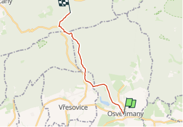

5.7 km | 7.9 km-effort
![Trail On foot Osvětimany - [Ž] Osvětimany - Cimburk - Photo](https://media.geolcdn.com/t/1900/400/15372c2e-66a9-4cae-88d5-9ba2e0c3fa37.jpeg&format=pjpeg&maxdim=2)

Tous les sentiers balisés d’Europe GUIDE+


FREE GPS app for hiking
 SityTrail
IGN / Geographical institutes
SityTrail World
The world is yours!
Trail On foot of 7.2 km to be discovered at Central Moravia, Zlínský kraj, Osvětimany. This trail is proposed by SityTrail - itinéraires balisés pédestres.
Trail created by cz:KČT.
yellow foot
Symbol: major
![Trail On foot Osvětimany - [Ž] Osvětimany - Cimburk - Photo 1](https://media.geolcdn.com/t/2048/auto/e043775e-71fc-4020-a101-cd3bd5ed50d8.jpeg&format=jpg&maxdim=0 "Trail On foot Osvětimany - [Ž] Osvětimany - Cimburk - Photo 1")
![Trail On foot Osvětimany - [Ž] Osvětimany - Cimburk - Photo 2](https://media.geolcdn.com/t/2048/auto/36bbd0f3-7ba4-460e-be9c-efdafdb9ab63.jpeg&format=jpg&maxdim=0 "Trail On foot Osvětimany - [Ž] Osvětimany - Cimburk - Photo 2")
![Trail On foot Osvětimany - [Ž] Osvětimany - Cimburk - Photo 3](https://media.geolcdn.com/t/2048/auto/23ff07a8-183d-4f17-ada9-19a689038e1f.jpeg&format=jpg&maxdim=0 "Trail On foot Osvětimany - [Ž] Osvětimany - Cimburk - Photo 3")
![Trail On foot Osvětimany - [Ž] Osvětimany - Cimburk - Photo 4](https://media.geolcdn.com/t/2048/auto/c19742de-9fd6-4997-ae3d-1262e6a20727.jpeg&format=jpg&maxdim=0 "Trail On foot Osvětimany - [Ž] Osvětimany - Cimburk - Photo 4")
![Trail On foot Osvětimany - [Ž] Osvětimany - Cimburk - Photo 5](https://media.geolcdn.com/t/2048/auto/072ba0a5-0422-4c44-8250-0ee1932f60b6.jpeg&format=jpg&maxdim=0 "Trail On foot Osvětimany - [Ž] Osvětimany - Cimburk - Photo 5")
![Trail On foot Osvětimany - [Ž] Osvětimany - Cimburk - Photo 6](https://media.geolcdn.com/t/2048/auto/f09211dd-3fb0-4938-81a1-c776d2e69671.jpeg&format=jpg&maxdim=0 "Trail On foot Osvětimany - [Ž] Osvětimany - Cimburk - Photo 6")
![Trail On foot Osvětimany - [Ž] Osvětimany - Cimburk - Photo 7](https://media.geolcdn.com/t/2048/auto/d633a07f-766f-4e4c-9090-31a604da373d.jpeg&format=jpg&maxdim=0 "Trail On foot Osvětimany - [Ž] Osvětimany - Cimburk - Photo 7")
![Trail On foot Osvětimany - [Ž] Osvětimany - Cimburk - Photo 8](https://media.geolcdn.com/t/2048/auto/b64d28ba-a7dc-485f-8151-65516c3f1cd9.jpeg&format=jpg&maxdim=0 "Trail On foot Osvětimany - [Ž] Osvětimany - Cimburk - Photo 8")
![Trail On foot Osvětimany - [Ž] Osvětimany - Cimburk - Photo 9](https://media.geolcdn.com/t/2048/auto/15372c2e-66a9-4cae-88d5-9ba2e0c3fa37.jpeg&format=jpg&maxdim=0 "Trail On foot Osvětimany - [Ž] Osvětimany - Cimburk - Photo 9")
![Trail On foot Osvětimany - [Ž] Osvětimany - Cimburk - Photo 10](https://media.geolcdn.com/t/2048/auto/e59228e5-8d58-4288-8ea3-1b61a792e25d.jpeg&format=jpg&maxdim=0 "Trail On foot Osvětimany - [Ž] Osvětimany - Cimburk - Photo 10")
On foot
On foot
![Trail On foot Brankovice - [Č] Brankovice - Švábenice - Photo](https://media.geolcdn.com/t/375/260/e8fb4ecb-25ca-4aad-b7f0-202984a811e1.jpeg&format=jpg&maxdim=2)
On foot
![Trail On foot Nemochovice - [Z] Zadní jezírko - Nemochovice - Photo](https://media.geolcdn.com/t/375/260/c9ea8e06-da0a-4b8b-961a-a5049e889dd8.jpeg&format=jpg&maxdim=2)
On foot
On foot
![Trail On foot Ždánice - [Ž] Černčín - Bučovice - Photo](https://media.geolcdn.com/t/375/260/0e8a5bf5-67a6-4aaf-a695-d3a2c91aad48.jpeg&format=jpg&maxdim=2)
On foot
![Trail On foot Roštín - [Ž] Roštínská kaple - Bunč - Photo](https://media.geolcdn.com/t/375/260/4eacabd4-450a-4e5f-93af-313922c3e823.jpeg&format=jpg&maxdim=2)
On foot
On foot
![Trail On foot Buchlovice - [Ž] Na Pile - Buchlov - Photo](https://media.geolcdn.com/t/375/260/cd9f3d7e-9687-4966-bede-9521b1c3aff1.jpeg&format=jpg&maxdim=2)
On foot