


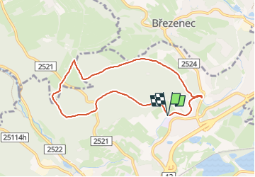

3.5 km | 5.3 km-effort
![Trail On foot Chomutov - [Č] 0358 Březenecký okruh - Photo](https://media.geolcdn.com/t/1900/400/d269c281-10b2-4a2c-a352-57960a37ce6b.jpeg&format=pjpeg&maxdim=2)

Tous les sentiers balisés d’Europe GUIDE+


FREE GPS app for hiking
 SityTrail
IGN / Geographical institutes
SityTrail World
The world is yours!
Trail On foot of 7 km to be discovered at Northwest, Ústecký kraj, Chomutov. This trail is proposed by SityTrail - itinéraires balisés pédestres.
Trail created by cz:KČT.
![Trail On foot Chomutov - [Č] 0358 Březenecký okruh - Photo 1](https://media.geolcdn.com/t/2048/auto/3ea3d748-47e1-48c6-8554-b9db3fb82e1d.jpeg&format=jpg&maxdim=0 "Trail On foot Chomutov - [Č] 0358 Březenecký okruh - Photo 1")
![Trail On foot Chomutov - [Č] 0358 Březenecký okruh - Photo 2](https://media.geolcdn.com/t/2048/auto/ac03d7ba-fe3b-45a7-8fed-6b52997cfe2e.jpeg&format=jpg&maxdim=0 "Trail On foot Chomutov - [Č] 0358 Březenecký okruh - Photo 2")
![Trail On foot Chomutov - [Č] 0358 Březenecký okruh - Photo 3](https://media.geolcdn.com/t/2048/auto/86e2cb78-e73d-42d8-a08f-472d0902043a.jpeg&format=jpg&maxdim=0 "Trail On foot Chomutov - [Č] 0358 Březenecký okruh - Photo 3")
![Trail On foot Chomutov - [Č] 0358 Březenecký okruh - Photo 4](https://media.geolcdn.com/t/2048/auto/c2b76415-260b-4090-993c-0597e27ff8e9.jpeg&format=jpg&maxdim=0 "Trail On foot Chomutov - [Č] 0358 Březenecký okruh - Photo 4")
![Trail On foot Chomutov - [Č] 0358 Březenecký okruh - Photo 5](https://media.geolcdn.com/t/2048/auto/bc063580-b413-4a41-bea5-7920fc202f95.jpeg&format=jpg&maxdim=0 "Trail On foot Chomutov - [Č] 0358 Březenecký okruh - Photo 5")
![Trail On foot Chomutov - [Č] 0358 Březenecký okruh - Photo 6](https://media.geolcdn.com/t/2048/auto/beafec68-6569-4944-bc4b-9b2657d2d7d2.jpeg&format=jpg&maxdim=0 "Trail On foot Chomutov - [Č] 0358 Březenecký okruh - Photo 6")
![Trail On foot Chomutov - [Č] 0358 Březenecký okruh - Photo 7](https://media.geolcdn.com/t/2048/auto/3969a2ce-ad3e-4155-8d2b-875ad0e21e58.jpeg&format=jpg&maxdim=0 "Trail On foot Chomutov - [Č] 0358 Březenecký okruh - Photo 7")
![Trail On foot Chomutov - [Č] 0358 Březenecký okruh - Photo 8](https://media.geolcdn.com/t/2048/auto/bb4c4511-51e1-490a-82c5-c4ff4cdfe548.jpeg&format=jpg&maxdim=0 "Trail On foot Chomutov - [Č] 0358 Březenecký okruh - Photo 8")
![Trail On foot Chomutov - [Č] 0358 Březenecký okruh - Photo 9](https://media.geolcdn.com/t/2048/auto/0916fe3d-b2b3-4f7c-abac-9d77e7434fd1.jpeg&format=jpg&maxdim=0 "Trail On foot Chomutov - [Č] 0358 Březenecký okruh - Photo 9")
![Trail On foot Chomutov - [Č] 0358 Březenecký okruh - Photo 10](https://media.geolcdn.com/t/2048/auto/d269c281-10b2-4a2c-a352-57960a37ce6b.jpeg&format=jpg&maxdim=0 "Trail On foot Chomutov - [Č] 0358 Březenecký okruh - Photo 10")
![Trail On foot Chomutov - [Ž] 6923 Povodí Ohře - Pod Partyzánem - Photo](https://media.geolcdn.com/t/375/260/371d693c-aea5-487c-96c0-7783e06f503d.jpeg&format=jpg&maxdim=2)
On foot
On foot