


7.9 km | 9 km-effort
![Trail On foot Mělník - [Z] Mělník - okružní trasa - Photo](https://media.geolcdn.com/t/1900/400/e6c96ca9-333e-4cf1-8b0e-018ae508ba3d.jpeg&format=pjpeg&maxdim=2)

Tous les sentiers balisés d’Europe GUIDE+


FREE GPS app for hiking
 SityTrail
IGN / Geographical institutes
SityTrail World
The world is yours!
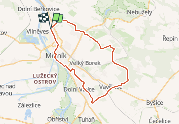
Trail On foot of 27 km to be discovered at Central Bohemia, Unknown, Mělník. This trail is proposed by SityTrail - itinéraires balisés pédestres.
Trail created by cz:KČT.
![Trail On foot Mělník - [Z] Mělník - okružní trasa - Photo 1](https://media.geolcdn.com/t/2048/auto/011c4b79-be87-4ae0-9590-5f0423fc980a.jpeg&format=jpg&maxdim=0 "Trail On foot Mělník - [Z] Mělník - okružní trasa - Photo 1")
![Trail On foot Mělník - [Z] Mělník - okružní trasa - Photo 2](https://media.geolcdn.com/t/2048/auto/e1370b09-bf2f-4507-8cbe-b33eac51a1c0.jpeg&format=jpg&maxdim=0 "Trail On foot Mělník - [Z] Mělník - okružní trasa - Photo 2")
![Trail On foot Mělník - [Z] Mělník - okružní trasa - Photo 3](https://media.geolcdn.com/t/2048/auto/f28d6203-309d-422d-9adc-ae33bb832c7c.jpeg&format=jpg&maxdim=0 "Trail On foot Mělník - [Z] Mělník - okružní trasa - Photo 3")
![Trail On foot Mělník - [Z] Mělník - okružní trasa - Photo 4](https://media.geolcdn.com/t/2048/auto/b5a75bb9-f228-46a2-9ec2-733e678d55d2.jpeg&format=jpg&maxdim=0 "Trail On foot Mělník - [Z] Mělník - okružní trasa - Photo 4")
![Trail On foot Mělník - [Z] Mělník - okružní trasa - Photo 5](https://media.geolcdn.com/t/2048/auto/08150dd1-2914-4d24-8ad3-5df5e3c33a7c.jpeg&format=jpg&maxdim=0 "Trail On foot Mělník - [Z] Mělník - okružní trasa - Photo 5")
![Trail On foot Mělník - [Z] Mělník - okružní trasa - Photo 6](https://media.geolcdn.com/t/2048/auto/de8a49db-6531-4bb8-a1d6-eaeadbe18dba.jpeg&format=jpg&maxdim=0 "Trail On foot Mělník - [Z] Mělník - okružní trasa - Photo 6")
![Trail On foot Mělník - [Z] Mělník - okružní trasa - Photo 7](https://media.geolcdn.com/t/2048/auto/d2c5e485-da11-42bf-b8f1-c36ca4154dcb.jpeg&format=jpg&maxdim=0 "Trail On foot Mělník - [Z] Mělník - okružní trasa - Photo 7")
![Trail On foot Mělník - [Z] Mělník - okružní trasa - Photo 8](https://media.geolcdn.com/t/2048/auto/4a7e4021-f05d-4c97-a09a-3cf9da490376.jpeg&format=jpg&maxdim=0 "Trail On foot Mělník - [Z] Mělník - okružní trasa - Photo 8")
![Trail On foot Mělník - [Z] Mělník - okružní trasa - Photo 9](https://media.geolcdn.com/t/2048/auto/e39b0bee-9f1d-4d39-a389-d252b24b9332.jpeg&format=jpg&maxdim=0 "Trail On foot Mělník - [Z] Mělník - okružní trasa - Photo 9")
![Trail On foot Mělník - [Z] Mělník - okružní trasa - Photo 10](https://media.geolcdn.com/t/2048/auto/e6c96ca9-333e-4cf1-8b0e-018ae508ba3d.jpeg&format=jpg&maxdim=0 "Trail On foot Mělník - [Z] Mělník - okružní trasa - Photo 10")
![Trail On foot Mělník - [Ž] Mělník - Lhotka - Photo](https://media.geolcdn.com/t/375/260/6568a527-c601-419a-b951-03eae086182d.jpeg&format=jpg&maxdim=2)
On foot