


4.5 km | 6.1 km-effort
![Trail On foot Měděnec - [Z] 3989 Perštejn (rozc.) - Horní Halže - Photo](https://media.geolcdn.com/t/1900/400/dce708ea-15cb-4dba-a636-1eae61d53d63.jpeg&format=pjpeg&maxdim=2)

Tous les sentiers balisés d’Europe GUIDE+


FREE GPS app for hiking
 SityTrail
IGN / Geographical institutes
SityTrail World
The world is yours!
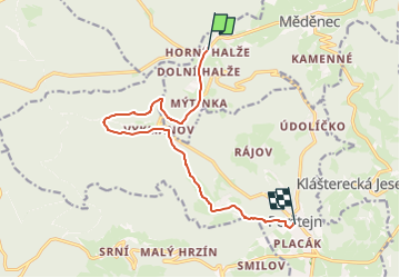
Trail On foot of 10 km to be discovered at Northwest, Ústecký kraj, Měděnec. This trail is proposed by SityTrail - itinéraires balisés pédestres.
Trail created by cz:KČT.
![Trail On foot Měděnec - [Z] 3989 Perštejn (rozc.) - Horní Halže - Photo 1](https://media.geolcdn.com/t/2048/auto/f544d9db-f6db-4261-abce-35efff4365a3.jpeg&format=jpg&maxdim=0 "Trail On foot Měděnec - [Z] 3989 Perštejn (rozc.) - Horní Halže - Photo 1")
![Trail On foot Měděnec - [Z] 3989 Perštejn (rozc.) - Horní Halže - Photo 2](https://media.geolcdn.com/t/2048/auto/769de224-fa36-493e-a21c-399f186e5bb5.jpeg&format=jpg&maxdim=0 "Trail On foot Měděnec - [Z] 3989 Perštejn (rozc.) - Horní Halže - Photo 2")
![Trail On foot Měděnec - [Z] 3989 Perštejn (rozc.) - Horní Halže - Photo 3](https://media.geolcdn.com/t/2048/auto/38a04ebc-9ae7-4138-9381-222a3075b687.jpeg&format=jpg&maxdim=0 "Trail On foot Měděnec - [Z] 3989 Perštejn (rozc.) - Horní Halže - Photo 3")
![Trail On foot Měděnec - [Z] 3989 Perštejn (rozc.) - Horní Halže - Photo 4](https://media.geolcdn.com/t/2048/auto/6a2bbb80-f1bc-42f6-916c-de290996a805.jpeg&format=jpg&maxdim=0 "Trail On foot Měděnec - [Z] 3989 Perštejn (rozc.) - Horní Halže - Photo 4")
![Trail On foot Měděnec - [Z] 3989 Perštejn (rozc.) - Horní Halže - Photo 5](https://media.geolcdn.com/t/2048/auto/74c666bd-2b6a-4269-b238-517ab53c1f6a.jpeg&format=jpg&maxdim=0 "Trail On foot Měděnec - [Z] 3989 Perštejn (rozc.) - Horní Halže - Photo 5")
![Trail On foot Měděnec - [Z] 3989 Perštejn (rozc.) - Horní Halže - Photo 6](https://media.geolcdn.com/t/2048/auto/c12581bc-5518-420d-968f-48d29183cdc7.jpeg&format=jpg&maxdim=0 "Trail On foot Měděnec - [Z] 3989 Perštejn (rozc.) - Horní Halže - Photo 6")
![Trail On foot Měděnec - [Z] 3989 Perštejn (rozc.) - Horní Halže - Photo 7](https://media.geolcdn.com/t/2048/auto/e486c2dd-40e5-48fc-b7ef-36376b71e2f2.jpeg&format=jpg&maxdim=0 "Trail On foot Měděnec - [Z] 3989 Perštejn (rozc.) - Horní Halže - Photo 7")
![Trail On foot Měděnec - [Z] 3989 Perštejn (rozc.) - Horní Halže - Photo 8](https://media.geolcdn.com/t/2048/auto/b896e8b8-89c4-46d5-a808-2d3cd1e74e65.jpeg&format=jpg&maxdim=0 "Trail On foot Měděnec - [Z] 3989 Perštejn (rozc.) - Horní Halže - Photo 8")
![Trail On foot Měděnec - [Z] 3989 Perštejn (rozc.) - Horní Halže - Photo 9](https://media.geolcdn.com/t/2048/auto/93322e2a-78f8-4076-8be1-d313cbf251fd.jpeg&format=jpg&maxdim=0 "Trail On foot Měděnec - [Z] 3989 Perštejn (rozc.) - Horní Halže - Photo 9")
![Trail On foot Měděnec - [Z] 3989 Perštejn (rozc.) - Horní Halže - Photo 10](https://media.geolcdn.com/t/2048/auto/dce708ea-15cb-4dba-a636-1eae61d53d63.jpeg&format=jpg&maxdim=0 "Trail On foot Měděnec - [Z] 3989 Perštejn (rozc.) - Horní Halže - Photo 10")
![Trail On foot Měděnec - [Ž] 6990 Perštejn - Mýtinka - Photo](https://media.geolcdn.com/t/375/260/dce708ea-15cb-4dba-a636-1eae61d53d63.jpeg&format=jpg&maxdim=2)
On foot