


3.2 km | 5.1 km-effort
![Trail On foot Potůčky - [Ž] Pernink - Nové Hamry - Photo](https://media.geolcdn.com/t/1900/400/f5edafe6-81d2-4c68-9506-f8acbfbc5ef6.jpeg&format=pjpeg&maxdim=2)

Tous les sentiers balisés d’Europe GUIDE+


FREE GPS app for hiking
 SityTrail
IGN / Geographical institutes
SityTrail World
The world is yours!
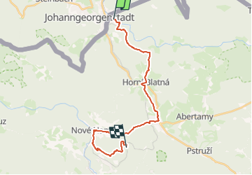
Trail On foot of 21 km to be discovered at Northwest, Karlovarský kraj, Potůčky. This trail is proposed by SityTrail - itinéraires balisés pédestres.
Trail created by cz:KČT.
![Trail On foot Potůčky - [Ž] Pernink - Nové Hamry - Photo 1](https://media.geolcdn.com/t/2048/auto/d58264f4-6030-4dd2-9d8a-a190071b60d5.jpeg&format=jpg&maxdim=0 "Trail On foot Potůčky - [Ž] Pernink - Nové Hamry - Photo 1")
![Trail On foot Potůčky - [Ž] Pernink - Nové Hamry - Photo 2](https://media.geolcdn.com/t/2048/auto/695e175c-f5e7-41ba-aa49-67a618aea285.jpeg&format=jpg&maxdim=0 "Trail On foot Potůčky - [Ž] Pernink - Nové Hamry - Photo 2")
![Trail On foot Potůčky - [Ž] Pernink - Nové Hamry - Photo 3](https://media.geolcdn.com/t/2048/auto/9aa57f4d-b2d0-4518-a5fa-3a2dc6073b27.jpeg&format=jpg&maxdim=0 "Trail On foot Potůčky - [Ž] Pernink - Nové Hamry - Photo 3")
![Trail On foot Potůčky - [Ž] Pernink - Nové Hamry - Photo 4](https://media.geolcdn.com/t/2048/auto/1fc47912-2cc8-4433-a272-47643f2d5b5d.jpeg&format=jpg&maxdim=0 "Trail On foot Potůčky - [Ž] Pernink - Nové Hamry - Photo 4")
![Trail On foot Potůčky - [Ž] Pernink - Nové Hamry - Photo 5](https://media.geolcdn.com/t/2048/auto/0f0ed540-3175-4913-aab0-fe95725133f1.jpeg&format=jpg&maxdim=0 "Trail On foot Potůčky - [Ž] Pernink - Nové Hamry - Photo 5")
![Trail On foot Potůčky - [Ž] Pernink - Nové Hamry - Photo 6](https://media.geolcdn.com/t/2048/auto/fe616030-305d-41c0-9bf8-81a2ee1f178d.jpeg&format=jpg&maxdim=0 "Trail On foot Potůčky - [Ž] Pernink - Nové Hamry - Photo 6")
![Trail On foot Potůčky - [Ž] Pernink - Nové Hamry - Photo 7](https://media.geolcdn.com/t/2048/auto/b480d955-f8ec-46b2-8185-b67b58b4a25f.jpeg&format=jpg&maxdim=0 "Trail On foot Potůčky - [Ž] Pernink - Nové Hamry - Photo 7")
![Trail On foot Potůčky - [Ž] Pernink - Nové Hamry - Photo 8](https://media.geolcdn.com/t/2048/auto/96206a2b-a451-48b7-a576-c39de45b5c1f.jpeg&format=jpg&maxdim=0 "Trail On foot Potůčky - [Ž] Pernink - Nové Hamry - Photo 8")
![Trail On foot Potůčky - [Ž] Pernink - Nové Hamry - Photo 9](https://media.geolcdn.com/t/2048/auto/e39e6354-cd11-412f-a904-48e37a435106.jpeg&format=jpg&maxdim=0 "Trail On foot Potůčky - [Ž] Pernink - Nové Hamry - Photo 9")
![Trail On foot Potůčky - [Ž] Pernink - Nové Hamry - Photo 10](https://media.geolcdn.com/t/2048/auto/f5edafe6-81d2-4c68-9506-f8acbfbc5ef6.jpeg&format=jpg&maxdim=0 "Trail On foot Potůčky - [Ž] Pernink - Nové Hamry - Photo 10")
On foot
On foot

On foot
On foot
On foot
On foot