


3.3 km | 4.9 km-effort
![Trail On foot Běstvina - [Z] Běstvina - Seč - Photo](https://media.geolcdn.com/t/1900/400/1fe36d45-751d-4c3f-8910-968f469449fc.jpeg&format=pjpeg&maxdim=2)

Tous les sentiers balisés d’Europe GUIDE+


FREE GPS app for hiking
 SityTrail
IGN / Geographical institutes
SityTrail World
The world is yours!
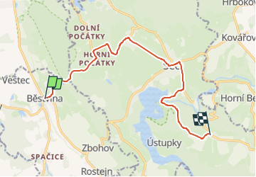
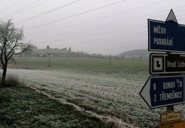
Trail On foot of 11.2 km to be discovered at Northeast, Pardubický kraj, Běstvina. This trail is proposed by SityTrail - itinéraires balisés pédestres.
Trail created by cz:KČT.
![Trail On foot Běstvina - [Z] Běstvina - Seč - Photo 1](https://media.geolcdn.com/t/2048/auto/49ef3542-998f-4847-86ed-96acdd7b6989.jpeg&format=jpg&maxdim=0 "Trail On foot Běstvina - [Z] Běstvina - Seč - Photo 1")
![Trail On foot Běstvina - [Z] Běstvina - Seč - Photo 2](https://media.geolcdn.com/t/2048/auto/87924d6f-d9ee-4e3d-bb4b-76c481fe29a9.jpeg&format=jpg&maxdim=0 "Trail On foot Běstvina - [Z] Běstvina - Seč - Photo 2")
![Trail On foot Běstvina - [Z] Běstvina - Seč - Photo 3](https://media.geolcdn.com/t/2048/auto/6666a716-b5cb-4cdc-96f8-0eb8d7429fb0.jpeg&format=jpg&maxdim=0 "Trail On foot Běstvina - [Z] Běstvina - Seč - Photo 3")
![Trail On foot Běstvina - [Z] Běstvina - Seč - Photo 4](https://media.geolcdn.com/t/2048/auto/0c0d6ebd-e933-460c-9729-60979dfd65ff.jpeg&format=jpg&maxdim=0 "Trail On foot Běstvina - [Z] Běstvina - Seč - Photo 4")
![Trail On foot Běstvina - [Z] Běstvina - Seč - Photo 5](https://media.geolcdn.com/t/2048/auto/17f8b426-b0dc-4a32-ac75-8d08cc3fb24e.jpeg&format=jpg&maxdim=0 "Trail On foot Běstvina - [Z] Běstvina - Seč - Photo 5")
![Trail On foot Běstvina - [Z] Běstvina - Seč - Photo 6](https://media.geolcdn.com/t/2048/auto/c4254542-c419-4b7d-a1b5-00ed2b1708d3.jpeg&format=jpg&maxdim=0 "Trail On foot Běstvina - [Z] Běstvina - Seč - Photo 6")
![Trail On foot Běstvina - [Z] Běstvina - Seč - Photo 7](https://media.geolcdn.com/t/2048/auto/552c4c1b-03da-45cc-9115-52a9b5d735d8.jpeg&format=jpg&maxdim=0 "Trail On foot Běstvina - [Z] Běstvina - Seč - Photo 7")
![Trail On foot Běstvina - [Z] Běstvina - Seč - Photo 8](https://media.geolcdn.com/t/2048/auto/2c4c93a7-eb49-474f-a114-5d836481fcb9.jpeg&format=jpg&maxdim=0 "Trail On foot Běstvina - [Z] Běstvina - Seč - Photo 8")
![Trail On foot Běstvina - [Z] Běstvina - Seč - Photo 9](https://media.geolcdn.com/t/2048/auto/64e23a9d-cc41-4a41-8170-12c846c0aefa.jpeg&format=jpg&maxdim=0 "Trail On foot Běstvina - [Z] Běstvina - Seč - Photo 9")
![Trail On foot Běstvina - [Z] Běstvina - Seč - Photo 10](https://media.geolcdn.com/t/2048/auto/1fe36d45-751d-4c3f-8910-968f469449fc.jpeg&format=jpg&maxdim=0 "Trail On foot Běstvina - [Z] Běstvina - Seč - Photo 10")
On foot