


5.5 km | 7.8 km-effort
![Trail On foot Netvořice - [M] Netvořice - Chrášťany - Photo](https://media.geolcdn.com/t/1900/400/6efde026-0ce2-46af-8474-d88eb2e450cd.jpeg&format=pjpeg&maxdim=2)

Tous les sentiers balisés d’Europe GUIDE+


FREE GPS app for hiking
 SityTrail
IGN / Geographical institutes
SityTrail World
The world is yours!
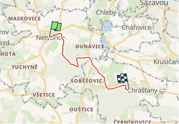
Trail On foot of 7 km to be discovered at Central Bohemia, Unknown, Netvořice. This trail is proposed by SityTrail - itinéraires balisés pédestres.
Trail created by cz:KČT.
![Trail On foot Netvořice - [M] Netvořice - Chrášťany - Photo 1](https://media.geolcdn.com/t/2048/auto/cd5f7154-fa35-490d-8010-1704e7335062.jpeg&format=jpg&maxdim=0 "Trail On foot Netvořice - [M] Netvořice - Chrášťany - Photo 1")
![Trail On foot Netvořice - [M] Netvořice - Chrášťany - Photo 2](https://media.geolcdn.com/t/2048/auto/f3fc6590-ce5d-45b2-a47d-4f4a13f191eb.jpeg&format=jpg&maxdim=0 "Trail On foot Netvořice - [M] Netvořice - Chrášťany - Photo 2")
![Trail On foot Netvořice - [M] Netvořice - Chrášťany - Photo 3](https://media.geolcdn.com/t/2048/auto/6288b2ce-c66b-4c39-b911-7f046d6dcd8f.jpeg&format=jpg&maxdim=0 "Trail On foot Netvořice - [M] Netvořice - Chrášťany - Photo 3")
![Trail On foot Netvořice - [M] Netvořice - Chrášťany - Photo 4](https://media.geolcdn.com/t/2048/auto/a7479687-ac3a-43a7-a184-d219cc1ee822.jpeg&format=jpg&maxdim=0 "Trail On foot Netvořice - [M] Netvořice - Chrášťany - Photo 4")
![Trail On foot Netvořice - [M] Netvořice - Chrášťany - Photo 5](https://media.geolcdn.com/t/2048/auto/871fa5f3-ec64-41b7-8201-8ec6418ee9a1.jpeg&format=jpg&maxdim=0 "Trail On foot Netvořice - [M] Netvořice - Chrášťany - Photo 5")
![Trail On foot Netvořice - [M] Netvořice - Chrášťany - Photo 6](https://media.geolcdn.com/t/2048/auto/d9f75595-e78c-46eb-935a-f877493c78e5.jpeg&format=jpg&maxdim=0 "Trail On foot Netvořice - [M] Netvořice - Chrášťany - Photo 6")
![Trail On foot Netvořice - [M] Netvořice - Chrášťany - Photo 7](https://media.geolcdn.com/t/2048/auto/fc62cde7-eacd-46d6-a146-c763620bb71f.jpeg&format=jpg&maxdim=0 "Trail On foot Netvořice - [M] Netvořice - Chrášťany - Photo 7")
![Trail On foot Netvořice - [M] Netvořice - Chrášťany - Photo 8](https://media.geolcdn.com/t/2048/auto/229f1ef1-1f51-40e8-a2f8-8e408d855040.jpeg&format=jpg&maxdim=0 "Trail On foot Netvořice - [M] Netvořice - Chrášťany - Photo 8")
![Trail On foot Netvořice - [M] Netvořice - Chrášťany - Photo 9](https://media.geolcdn.com/t/2048/auto/8030a3ab-b526-47d6-b14e-8391b2479b5b.jpeg&format=jpg&maxdim=0 "Trail On foot Netvořice - [M] Netvořice - Chrášťany - Photo 9")
![Trail On foot Netvořice - [M] Netvořice - Chrášťany - Photo 10](https://media.geolcdn.com/t/2048/auto/6efde026-0ce2-46af-8474-d88eb2e450cd.jpeg&format=jpg&maxdim=0 "Trail On foot Netvořice - [M] Netvořice - Chrášťany - Photo 10")
![Trail On foot Krňany - [Z] Pikovice - Pod Třebsínem - Photo](https://media.geolcdn.com/t/375/260/9d973daa-efdc-425c-b30b-77795e7c71fa.jpeg&format=jpg&maxdim=2)
On foot