


3.7 km | 4 km-effort
![Trail On foot Chotěšov - [Z] Chotěšov - Chudenice - Photo](https://media.geolcdn.com/t/1900/400/db6e0667-71ef-4d53-8b64-8b347f6d468d.jpeg&format=pjpeg&maxdim=2)

Tous les sentiers balisés d’Europe GUIDE+


FREE GPS app for hiking
 SityTrail
IGN / Geographical institutes
SityTrail World
The world is yours!
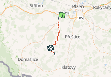
Trail On foot of 29 km to be discovered at Southwest, Plzeňský kraj, Chotěšov. This trail is proposed by SityTrail - itinéraires balisés pédestres.
Trail created by cz:KČT.
![Trail On foot Chotěšov - [Z] Chotěšov - Chudenice - Photo 1](https://media.geolcdn.com/t/2048/auto/ff662d29-161e-4a2a-a788-1bd6676c8269.jpeg&format=jpg&maxdim=0 "Trail On foot Chotěšov - [Z] Chotěšov - Chudenice - Photo 1")
![Trail On foot Chotěšov - [Z] Chotěšov - Chudenice - Photo 2](https://media.geolcdn.com/t/2048/auto/d60b7b98-b4c1-4fb9-83a1-45064b2e0987.jpeg&format=jpg&maxdim=0 "Trail On foot Chotěšov - [Z] Chotěšov - Chudenice - Photo 2")
![Trail On foot Chotěšov - [Z] Chotěšov - Chudenice - Photo 3](https://media.geolcdn.com/t/2048/auto/43f23aa5-0d61-42f0-b58b-afb9240a6950.jpeg&format=jpg&maxdim=0 "Trail On foot Chotěšov - [Z] Chotěšov - Chudenice - Photo 3")
![Trail On foot Chotěšov - [Z] Chotěšov - Chudenice - Photo 4](https://media.geolcdn.com/t/2048/auto/753e0663-1b8b-4fb2-8a74-c12e26afec19.jpeg&format=jpg&maxdim=0 "Trail On foot Chotěšov - [Z] Chotěšov - Chudenice - Photo 4")
![Trail On foot Chotěšov - [Z] Chotěšov - Chudenice - Photo 5](https://media.geolcdn.com/t/2048/auto/da580324-c571-46d6-a573-295a02a0d6ca.jpeg&format=jpg&maxdim=0 "Trail On foot Chotěšov - [Z] Chotěšov - Chudenice - Photo 5")
![Trail On foot Chotěšov - [Z] Chotěšov - Chudenice - Photo 6](https://media.geolcdn.com/t/2048/auto/d66e96b0-60af-4d10-ae85-8f98b49a05b3.jpeg&format=jpg&maxdim=0 "Trail On foot Chotěšov - [Z] Chotěšov - Chudenice - Photo 6")
![Trail On foot Chotěšov - [Z] Chotěšov - Chudenice - Photo 7](https://media.geolcdn.com/t/2048/auto/8d5c8572-16d7-49aa-bdb8-9a74747a87be.jpeg&format=jpg&maxdim=0 "Trail On foot Chotěšov - [Z] Chotěšov - Chudenice - Photo 7")
![Trail On foot Chotěšov - [Z] Chotěšov - Chudenice - Photo 8](https://media.geolcdn.com/t/2048/auto/0616213e-9615-41d0-9483-662a189b3589.jpeg&format=jpg&maxdim=0 "Trail On foot Chotěšov - [Z] Chotěšov - Chudenice - Photo 8")
![Trail On foot Chotěšov - [Z] Chotěšov - Chudenice - Photo 9](https://media.geolcdn.com/t/2048/auto/db6e0667-71ef-4d53-8b64-8b347f6d468d.jpeg&format=jpg&maxdim=0 "Trail On foot Chotěšov - [Z] Chotěšov - Chudenice - Photo 9")
![Trail On foot Chotěšov - [Z] Chotěšov - Chudenice - Photo 10](https://media.geolcdn.com/t/2048/auto/3b8a67f3-a931-4a2e-99c8-ceb576d366b5.jpeg&format=jpg&maxdim=0 "Trail On foot Chotěšov - [Z] Chotěšov - Chudenice - Photo 10")
![Trail On foot Stod - [Ž] Stod - Vytůň - Photo](https://media.geolcdn.com/t/375/260/5f465939-ef20-4d07-aeae-d7b7b507e19b.jpeg&format=jpg&maxdim=2)
On foot
![Trail On foot Líně - [Č] Líňská okružní trasa - Photo](https://media.geolcdn.com/t/375/260/cbeb49cd-7fbd-4b7b-bd64-d76bac41e164.jpeg&format=jpg&maxdim=2)
On foot