


5.2 km | 7 km-effort
![Trail On foot Skorošice - [Ž] Lázně Jeseník - Špičák - Photo](https://media.geolcdn.com/t/1900/400/1cce9d3b-ebfd-4239-9158-7e92f3a7cb87.jpeg&format=pjpeg&maxdim=2)

Tous les sentiers balisés d’Europe GUIDE+


FREE GPS app for hiking
 SityTrail
IGN / Geographical institutes
SityTrail World
The world is yours!
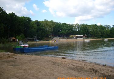
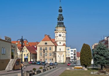
Trail On foot of 25 km to be discovered at Central Moravia, Olomouc Region, Skorošice. This trail is proposed by SityTrail - itinéraires balisés pédestres.
Trail created by cz:KČT.
![Trail On foot Skorošice - [Ž] Lázně Jeseník - Špičák - Photo 1](https://media.geolcdn.com/t/2048/auto/f41dba7f-be43-4b3e-a795-175f74a14773.jpeg&format=jpg&maxdim=0 "Trail On foot Skorošice - [Ž] Lázně Jeseník - Špičák - Photo 1")
![Trail On foot Skorošice - [Ž] Lázně Jeseník - Špičák - Photo 2](https://media.geolcdn.com/t/2048/auto/1b258c44-e960-49db-ade1-b3d9bf17f542.jpeg&format=jpg&maxdim=0 "Trail On foot Skorošice - [Ž] Lázně Jeseník - Špičák - Photo 2")
![Trail On foot Skorošice - [Ž] Lázně Jeseník - Špičák - Photo 3](https://media.geolcdn.com/t/2048/auto/d3b8cfdc-37e2-4540-aa9a-49fa5d5cf9af.jpeg&format=jpg&maxdim=0 "Trail On foot Skorošice - [Ž] Lázně Jeseník - Špičák - Photo 3")
![Trail On foot Skorošice - [Ž] Lázně Jeseník - Špičák - Photo 4](https://media.geolcdn.com/t/2048/auto/995cab2a-6da3-429c-bc68-5ef15dfe497b.jpeg&format=jpg&maxdim=0 "Trail On foot Skorošice - [Ž] Lázně Jeseník - Špičák - Photo 4")
![Trail On foot Skorošice - [Ž] Lázně Jeseník - Špičák - Photo 5](https://media.geolcdn.com/t/2048/auto/2fff16b1-da4a-4dd2-b0b2-5d8b39a85d0e.jpeg&format=jpg&maxdim=0 "Trail On foot Skorošice - [Ž] Lázně Jeseník - Špičák - Photo 5")
![Trail On foot Skorošice - [Ž] Lázně Jeseník - Špičák - Photo 6](https://media.geolcdn.com/t/2048/auto/f4cfd8f7-0322-4d43-a97b-58623da220c2.jpeg&format=jpg&maxdim=0 "Trail On foot Skorošice - [Ž] Lázně Jeseník - Špičák - Photo 6")
![Trail On foot Skorošice - [Ž] Lázně Jeseník - Špičák - Photo 7](https://media.geolcdn.com/t/2048/auto/1678ce69-533c-466a-872b-86169bb22c18.jpeg&format=jpg&maxdim=0 "Trail On foot Skorošice - [Ž] Lázně Jeseník - Špičák - Photo 7")
![Trail On foot Skorošice - [Ž] Lázně Jeseník - Špičák - Photo 8](https://media.geolcdn.com/t/2048/auto/f906c2ff-9719-4efd-8745-b3899ac79c38.jpeg&format=jpg&maxdim=0 "Trail On foot Skorošice - [Ž] Lázně Jeseník - Špičák - Photo 8")
![Trail On foot Skorošice - [Ž] Lázně Jeseník - Špičák - Photo 9](https://media.geolcdn.com/t/2048/auto/283d4f6a-1cff-400f-9bae-9c54eb28eca8.jpeg&format=jpg&maxdim=0 "Trail On foot Skorošice - [Ž] Lázně Jeseník - Špičák - Photo 9")
![Trail On foot Skorošice - [Ž] Lázně Jeseník - Špičák - Photo 10](https://media.geolcdn.com/t/2048/auto/1cce9d3b-ebfd-4239-9158-7e92f3a7cb87.jpeg&format=jpg&maxdim=0 "Trail On foot Skorošice - [Ž] Lázně Jeseník - Špičák - Photo 10")
![Trail On foot Lipová-lázně - [Č] Ramzová - Smrk - Photo](https://media.geolcdn.com/t/375/260/2e4c1233-6967-40e1-b71d-3baad939719d.jpeg&format=jpg&maxdim=2)
On foot
![Trail On foot Lipová-lázně - [Č] Lázně Lipová - Dolní Lipová - Photo](https://media.geolcdn.com/t/375/260/89666500-85c0-4bea-897f-f89baf646252.jpeg&format=jpg&maxdim=2)
On foot
On foot
![Trail On foot Staré Město - [Č] Staroměstský pevnostní okruh - Photo](https://media.geolcdn.com/t/375/260/0c86b44d-b49b-4018-84ce-ce37dde2e042.jpeg&format=jpg&maxdim=2)
On foot
![Trail On foot Staré Město - [Z] Staré město - Paprsek - Photo](https://media.geolcdn.com/t/375/260/604b9227-619f-49ba-bc9e-bf5c48d6c7dd.jpeg&format=jpg&maxdim=2)
On foot
![Trail On foot Staré Město - [M] Pod Starým kopcem - Smrk - Photo](https://media.geolcdn.com/t/375/260/063f9983-27cc-4304-b95b-e36ef4c486f7.jpeg&format=jpg&maxdim=2)
On foot
On foot
On foot

On foot