


3.7 km | 5.4 km-effort
![Trail On foot Trutnov - [Z] Bohuslavice n. U - Lhota - Photo](https://media.geolcdn.com/t/1900/400/d6dce303-85e9-4a12-8316-b404d3b52c6a.jpeg&format=pjpeg&maxdim=2)

Tous les sentiers balisés d’Europe GUIDE+


FREE GPS app for hiking
 SityTrail
IGN / Geographical institutes
SityTrail World
The world is yours!
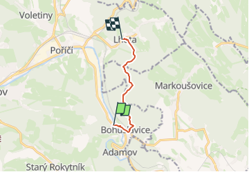
Trail On foot of 5 km to be discovered at Northeast, Královéhradecký kraj, Trutnov. This trail is proposed by SityTrail - itinéraires balisés pédestres.
Trail created by cz:KČT.
![Trail On foot Trutnov - [Z] Bohuslavice n. U - Lhota - Photo 1](https://media.geolcdn.com/t/2048/auto/e4ff149f-69b8-4fe7-94ca-0029a1248a57.jpeg&format=jpg&maxdim=0 "Trail On foot Trutnov - [Z] Bohuslavice n. U - Lhota - Photo 1")
![Trail On foot Trutnov - [Z] Bohuslavice n. U - Lhota - Photo 2](https://media.geolcdn.com/t/2048/auto/93373062-760e-43b2-b978-efba26e3ec63.jpeg&format=jpg&maxdim=0 "Trail On foot Trutnov - [Z] Bohuslavice n. U - Lhota - Photo 2")
![Trail On foot Trutnov - [Z] Bohuslavice n. U - Lhota - Photo 3](https://media.geolcdn.com/t/2048/auto/6e5f4a0e-dac8-4eb0-a108-ee168bbeda62.jpeg&format=jpg&maxdim=0 "Trail On foot Trutnov - [Z] Bohuslavice n. U - Lhota - Photo 3")
![Trail On foot Trutnov - [Z] Bohuslavice n. U - Lhota - Photo 4](https://media.geolcdn.com/t/2048/auto/ec853dc1-ead9-4613-8e93-87fab059e626.jpeg&format=jpg&maxdim=0 "Trail On foot Trutnov - [Z] Bohuslavice n. U - Lhota - Photo 4")
![Trail On foot Trutnov - [Z] Bohuslavice n. U - Lhota - Photo 5](https://media.geolcdn.com/t/2048/auto/58813086-d9e5-4bf1-be13-8f499076a33a.jpeg&format=jpg&maxdim=0 "Trail On foot Trutnov - [Z] Bohuslavice n. U - Lhota - Photo 5")
![Trail On foot Trutnov - [Z] Bohuslavice n. U - Lhota - Photo 6](https://media.geolcdn.com/t/2048/auto/0eb749b6-9f5a-466f-9301-212620eabff2.jpeg&format=jpg&maxdim=0 "Trail On foot Trutnov - [Z] Bohuslavice n. U - Lhota - Photo 6")
![Trail On foot Trutnov - [Z] Bohuslavice n. U - Lhota - Photo 7](https://media.geolcdn.com/t/2048/auto/134a693a-b8c1-4d7f-a7e0-9284063d9dc7.jpeg&format=jpg&maxdim=0 "Trail On foot Trutnov - [Z] Bohuslavice n. U - Lhota - Photo 7")
![Trail On foot Trutnov - [Z] Bohuslavice n. U - Lhota - Photo 8](https://media.geolcdn.com/t/2048/auto/277e597e-0fbe-4e66-8af9-e8f4d65939e4.jpeg&format=jpg&maxdim=0 "Trail On foot Trutnov - [Z] Bohuslavice n. U - Lhota - Photo 8")
![Trail On foot Trutnov - [Z] Bohuslavice n. U - Lhota - Photo 9](https://media.geolcdn.com/t/2048/auto/cb98d845-4561-40a6-bfed-c9868eb213fb.jpeg&format=jpg&maxdim=0 "Trail On foot Trutnov - [Z] Bohuslavice n. U - Lhota - Photo 9")
![Trail On foot Trutnov - [Z] Bohuslavice n. U - Lhota - Photo 10](https://media.geolcdn.com/t/2048/auto/d6dce303-85e9-4a12-8316-b404d3b52c6a.jpeg&format=jpg&maxdim=0 "Trail On foot Trutnov - [Z] Bohuslavice n. U - Lhota - Photo 10")
On foot
On foot