


11.8 km | 15 km-effort
![Trail On foot Dobříš - [Z] Dobříš - Kazatelna, okružní trasa - Photo](https://media.geolcdn.com/t/1900/400/73d47d22-080a-4d13-9f9d-c09866c7d376.jpeg&format=pjpeg&maxdim=2)

Tous les sentiers balisés d’Europe GUIDE+


FREE GPS app for hiking
 SityTrail
IGN / Geographical institutes
SityTrail World
The world is yours!
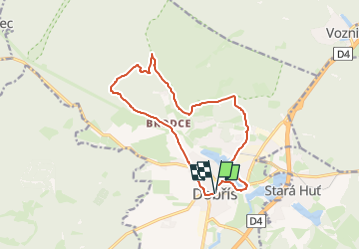
Trail On foot of 13 km to be discovered at Central Bohemia, Unknown, Dobříš. This trail is proposed by SityTrail - itinéraires balisés pédestres.
Trail created by cz:KČT.
![Trail On foot Dobříš - [Z] Dobříš - Kazatelna, okružní trasa - Photo 1](https://media.geolcdn.com/t/2048/auto/19193b0b-10e2-4278-8bf7-b9a59a098eb3.jpeg&format=jpg&maxdim=0 "Trail On foot Dobříš - [Z] Dobříš - Kazatelna, okružní trasa - Photo 1")
![Trail On foot Dobříš - [Z] Dobříš - Kazatelna, okružní trasa - Photo 2](https://media.geolcdn.com/t/2048/auto/55d66cae-e166-401d-afe5-9ef275269eb6.jpeg&format=jpg&maxdim=0 "Trail On foot Dobříš - [Z] Dobříš - Kazatelna, okružní trasa - Photo 2")
![Trail On foot Dobříš - [Z] Dobříš - Kazatelna, okružní trasa - Photo 3](https://media.geolcdn.com/t/2048/auto/bb53a028-127c-4234-b9f7-1fc9e443b5b3.jpeg&format=jpg&maxdim=0 "Trail On foot Dobříš - [Z] Dobříš - Kazatelna, okružní trasa - Photo 3")
![Trail On foot Dobříš - [Z] Dobříš - Kazatelna, okružní trasa - Photo 4](https://media.geolcdn.com/t/2048/auto/f5f37ff6-54ce-4bd5-bd6a-62c0beaab123.jpeg&format=jpg&maxdim=0 "Trail On foot Dobříš - [Z] Dobříš - Kazatelna, okružní trasa - Photo 4")
![Trail On foot Dobříš - [Z] Dobříš - Kazatelna, okružní trasa - Photo 5](https://media.geolcdn.com/t/2048/auto/5af19675-29a7-4cc2-ac39-b40e5d8cd876.jpeg&format=jpg&maxdim=0 "Trail On foot Dobříš - [Z] Dobříš - Kazatelna, okružní trasa - Photo 5")
![Trail On foot Dobříš - [Z] Dobříš - Kazatelna, okružní trasa - Photo 6](https://media.geolcdn.com/t/2048/auto/570ddc82-640c-41ca-bfea-52296b17d3d3.jpeg&format=jpg&maxdim=0 "Trail On foot Dobříš - [Z] Dobříš - Kazatelna, okružní trasa - Photo 6")
![Trail On foot Dobříš - [Z] Dobříš - Kazatelna, okružní trasa - Photo 7](https://media.geolcdn.com/t/2048/auto/3d7d1358-1df1-44bd-a9da-9a695ff78231.jpeg&format=jpg&maxdim=0 "Trail On foot Dobříš - [Z] Dobříš - Kazatelna, okružní trasa - Photo 7")
![Trail On foot Dobříš - [Z] Dobříš - Kazatelna, okružní trasa - Photo 8](https://media.geolcdn.com/t/2048/auto/8cb5c035-8b01-47a9-aa6e-43891bed5212.jpeg&format=jpg&maxdim=0 "Trail On foot Dobříš - [Z] Dobříš - Kazatelna, okružní trasa - Photo 8")
![Trail On foot Dobříš - [Z] Dobříš - Kazatelna, okružní trasa - Photo 9](https://media.geolcdn.com/t/2048/auto/92adf377-6937-4a03-a388-516bfc973f2e.jpeg&format=jpg&maxdim=0 "Trail On foot Dobříš - [Z] Dobříš - Kazatelna, okružní trasa - Photo 9")
![Trail On foot Dobříš - [Z] Dobříš - Kazatelna, okružní trasa - Photo 10](https://media.geolcdn.com/t/2048/auto/73d47d22-080a-4d13-9f9d-c09866c7d376.jpeg&format=jpg&maxdim=0 "Trail On foot Dobříš - [Z] Dobříš - Kazatelna, okružní trasa - Photo 10")
![Trail On foot Stará Huť - [Č] Strž - Nečín - Photo](https://media.geolcdn.com/t/375/260/45f89b58-cabb-4e58-9772-0518213db066.jpeg&format=jpg&maxdim=2)
On foot
![Trail On foot Voznice - [Ž] Mníšek pod Brdy-Voznice - Photo](https://media.geolcdn.com/t/375/260/5187661b-0cea-471d-915e-30f046d49d37.jpeg&format=jpg&maxdim=2)
On foot