


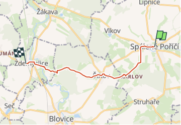

6.6 km | 9.8 km-effort
![Trail On foot Spálené Poříčí - [Ž] Spálené Pořičí - Zdemyslice - Photo](https://media.geolcdn.com/t/1900/400/1a4b968e-35de-4a8f-97c7-3b18afeaa3c1.jpeg&format=pjpeg&maxdim=2)

Tous les sentiers balisés d’Europe GUIDE+


FREE GPS app for hiking
 SityTrail
IGN / Geographical institutes
SityTrail World
The world is yours!
Trail On foot of 8.2 km to be discovered at Southwest, Plzeňský kraj, Spálené Poříčí. This trail is proposed by SityTrail - itinéraires balisés pédestres.
Trail created by cz:KČT.
![Trail On foot Spálené Poříčí - [Ž] Spálené Pořičí - Zdemyslice - Photo 1](https://media.geolcdn.com/t/2048/auto/a4050c8f-498f-4c48-89b9-2d92437db19b.jpeg&format=jpg&maxdim=0 "Trail On foot Spálené Poříčí - [Ž] Spálené Pořičí - Zdemyslice - Photo 1")
![Trail On foot Spálené Poříčí - [Ž] Spálené Pořičí - Zdemyslice - Photo 2](https://media.geolcdn.com/t/2048/auto/2d65b8ab-9844-4bc8-856c-2c3f31ae08a9.jpeg&format=jpg&maxdim=0 "Trail On foot Spálené Poříčí - [Ž] Spálené Pořičí - Zdemyslice - Photo 2")
![Trail On foot Spálené Poříčí - [Ž] Spálené Pořičí - Zdemyslice - Photo 3](https://media.geolcdn.com/t/2048/auto/ea48ae26-561c-487f-ac9a-ca6626c1d58f.jpeg&format=jpg&maxdim=0 "Trail On foot Spálené Poříčí - [Ž] Spálené Pořičí - Zdemyslice - Photo 3")
![Trail On foot Spálené Poříčí - [Ž] Spálené Pořičí - Zdemyslice - Photo 4](https://media.geolcdn.com/t/2048/auto/99881993-ca82-4c7f-a6ff-8132ec6cdc68.jpeg&format=jpg&maxdim=0 "Trail On foot Spálené Poříčí - [Ž] Spálené Pořičí - Zdemyslice - Photo 4")
![Trail On foot Spálené Poříčí - [Ž] Spálené Pořičí - Zdemyslice - Photo 5](https://media.geolcdn.com/t/2048/auto/26d4289a-bc6d-4877-a5d1-5d200ad9091f.jpeg&format=jpg&maxdim=0 "Trail On foot Spálené Poříčí - [Ž] Spálené Pořičí - Zdemyslice - Photo 5")
![Trail On foot Spálené Poříčí - [Ž] Spálené Pořičí - Zdemyslice - Photo 6](https://media.geolcdn.com/t/2048/auto/7c49aa60-4065-4b17-b49f-5c41431d1449.jpeg&format=jpg&maxdim=0 "Trail On foot Spálené Poříčí - [Ž] Spálené Pořičí - Zdemyslice - Photo 6")
![Trail On foot Spálené Poříčí - [Ž] Spálené Pořičí - Zdemyslice - Photo 7](https://media.geolcdn.com/t/2048/auto/b30d8cd8-d951-43f1-a17c-285632c76a90.jpeg&format=jpg&maxdim=0 "Trail On foot Spálené Poříčí - [Ž] Spálené Pořičí - Zdemyslice - Photo 7")
![Trail On foot Spálené Poříčí - [Ž] Spálené Pořičí - Zdemyslice - Photo 8](https://media.geolcdn.com/t/2048/auto/903a1672-0022-46ae-b027-b79e47154129.jpeg&format=jpg&maxdim=0 "Trail On foot Spálené Poříčí - [Ž] Spálené Pořičí - Zdemyslice - Photo 8")
![Trail On foot Spálené Poříčí - [Ž] Spálené Pořičí - Zdemyslice - Photo 9](https://media.geolcdn.com/t/2048/auto/4453dd03-4d4d-49d9-b0ab-f73f939506f8.jpeg&format=jpg&maxdim=0 "Trail On foot Spálené Poříčí - [Ž] Spálené Pořičí - Zdemyslice - Photo 9")
![Trail On foot Spálené Poříčí - [Ž] Spálené Pořičí - Zdemyslice - Photo 10](https://media.geolcdn.com/t/2048/auto/1a4b968e-35de-4a8f-97c7-3b18afeaa3c1.jpeg&format=jpg&maxdim=0 "Trail On foot Spálené Poříčí - [Ž] Spálené Pořičí - Zdemyslice - Photo 10")
![Trail On foot Hvožďany - [Z] Vacíkov - Třemšín - Photo](https://media.geolcdn.com/t/375/260/f1b092e8-e85a-4488-b770-d743603f9f8f.jpeg&format=jpg&maxdim=2)
On foot
![Trail On foot Rožmitál pod Třemšínem - [Č] Rožmitál p. T. - Třemšín - Photo](https://media.geolcdn.com/t/375/260/0689d70f-e711-4fe9-af24-fb32614d9884.jpeg&format=jpg&maxdim=2)
On foot
On foot
On foot
![Trail On foot Zaječov - [Ž] Svatá Dobrotivá - Kařízek - Photo](https://media.geolcdn.com/t/375/260/e689d382-4d8c-4668-997a-46922ae34690.jpeg&format=jpg&maxdim=2)
On foot
On foot
On foot
![Trail On foot Rožmitál pod Třemšínem - [Z] Rožmitál pod Třemšínem - U Padrťských rybníků - Photo](https://media.geolcdn.com/t/375/260/34eeebef-983f-4f05-9d42-741890d7d34c.jpeg&format=jpg&maxdim=2)
On foot
![Trail On foot Mýto - [M] Kamenný Újezd - Pod lesem u Mýta - Photo](https://media.geolcdn.com/t/375/260/182a32a0-41b9-4a36-a0c6-da1dec4ffa18.jpeg&format=jpg&maxdim=2)
On foot