


4.2 km | 5.2 km-effort
![Trail On foot Bratronice - [M] Kamenné Žehrovice - Bratronice - Photo](https://media.geolcdn.com/t/1900/400/62a19af9-67a3-4298-8dff-8290148c3bfe.jpeg&format=pjpeg&maxdim=2)

Tous les sentiers balisés d’Europe GUIDE+


FREE GPS app for hiking
 SityTrail
IGN / Geographical institutes
SityTrail World
The world is yours!
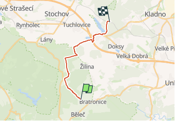
Trail On foot of 13.2 km to be discovered at Central Bohemia, Unknown, Bratronice. This trail is proposed by SityTrail - itinéraires balisés pédestres.
Trail created by cz:KČT.
![Trail On foot Bratronice - [M] Kamenné Žehrovice - Bratronice - Photo 1](https://media.geolcdn.com/t/2048/auto/13347129-e7cd-441e-9983-9e83dd23765e.jpeg&format=jpg&maxdim=0 "Trail On foot Bratronice - [M] Kamenné Žehrovice - Bratronice - Photo 1")
![Trail On foot Bratronice - [M] Kamenné Žehrovice - Bratronice - Photo 2](https://media.geolcdn.com/t/2048/auto/0df781a1-0809-4c32-9adc-0cf322898e50.jpeg&format=jpg&maxdim=0 "Trail On foot Bratronice - [M] Kamenné Žehrovice - Bratronice - Photo 2")
![Trail On foot Bratronice - [M] Kamenné Žehrovice - Bratronice - Photo 3](https://media.geolcdn.com/t/2048/auto/695324e7-f68c-4cca-a02f-41e62bb0c5af.jpeg&format=jpg&maxdim=0 "Trail On foot Bratronice - [M] Kamenné Žehrovice - Bratronice - Photo 3")
![Trail On foot Bratronice - [M] Kamenné Žehrovice - Bratronice - Photo 4](https://media.geolcdn.com/t/2048/auto/b734d67e-1ca6-432c-a592-bfb378229e08.jpeg&format=jpg&maxdim=0 "Trail On foot Bratronice - [M] Kamenné Žehrovice - Bratronice - Photo 4")
![Trail On foot Bratronice - [M] Kamenné Žehrovice - Bratronice - Photo 5](https://media.geolcdn.com/t/2048/auto/c2ec4612-f3d0-445d-9c4d-3e957dbcb67a.jpeg&format=jpg&maxdim=0 "Trail On foot Bratronice - [M] Kamenné Žehrovice - Bratronice - Photo 5")
![Trail On foot Bratronice - [M] Kamenné Žehrovice - Bratronice - Photo 6](https://media.geolcdn.com/t/2048/auto/7bc9156e-5cd4-42bf-9233-de1f8428bff0.jpeg&format=jpg&maxdim=0 "Trail On foot Bratronice - [M] Kamenné Žehrovice - Bratronice - Photo 6")
![Trail On foot Bratronice - [M] Kamenné Žehrovice - Bratronice - Photo 7](https://media.geolcdn.com/t/2048/auto/0ff321d1-df83-4620-a06c-70895f6e53f4.jpeg&format=jpg&maxdim=0 "Trail On foot Bratronice - [M] Kamenné Žehrovice - Bratronice - Photo 7")
![Trail On foot Bratronice - [M] Kamenné Žehrovice - Bratronice - Photo 8](https://media.geolcdn.com/t/2048/auto/5e27cb87-041b-4bc6-bf92-f13d7418852f.jpeg&format=jpg&maxdim=0 "Trail On foot Bratronice - [M] Kamenné Žehrovice - Bratronice - Photo 8")
![Trail On foot Bratronice - [M] Kamenné Žehrovice - Bratronice - Photo 9](https://media.geolcdn.com/t/2048/auto/07dd0d7c-d616-4bfa-83ca-bd0eebbb5fe9.jpeg&format=jpg&maxdim=0 "Trail On foot Bratronice - [M] Kamenné Žehrovice - Bratronice - Photo 9")
![Trail On foot Bratronice - [M] Kamenné Žehrovice - Bratronice - Photo 10](https://media.geolcdn.com/t/2048/auto/62a19af9-67a3-4298-8dff-8290148c3bfe.jpeg&format=jpg&maxdim=0 "Trail On foot Bratronice - [M] Kamenné Žehrovice - Bratronice - Photo 10")
![Trail On foot Běleč - [Ž] K háj.Kaly - Zbečno - Photo](https://media.geolcdn.com/t/375/260/d3d0538e-1238-40eb-8b04-d887f8bcd038.jpeg&format=jpg&maxdim=2)
On foot
![Trail On foot Bratronice - [Z] U Lánské obory - Roučmída - Photo](https://media.geolcdn.com/t/375/260/2c82548d-65b2-4354-bf3f-72bd56202ace.jpeg&format=jpg&maxdim=2)
On foot