![](/images/other/stat-length.png)
![Trail On foot Klingenthal - Rundwanderweg Klingenthal-Zwota - Photo](https://media.geolcdn.com/t/1900/400/44898a16-7c35-42f5-8612-f02ae3081798.jpeg&format=pjpeg&maxdim=2)
Rundwanderweg Klingenthal-Zwota
SityTrail - itinéraires balisés pédestres
Tous les sentiers balisés d’Europe GUIDE+
![Length](/images/other/stat-length.png)
![Max alt](https://static1.geolcdn.com/siteimages/upload/files/1508320355ic_sort_altitude_max_24dp.png)
![Uphill gradient](https://static1.geolcdn.com/siteimages/upload/files/1508320355ic_sort_den_pos_24dp.png)
![Km-Effort](/images/other/stat-length.png)
![Min alt](https://static1.geolcdn.com/siteimages/upload/files/1508320355ic_sort_altitude_min_24dp.png)
![Downhill gradient](https://static1.geolcdn.com/siteimages/upload/files/1508320355ic_sort_den_neg_24dp.png)
![Boucle](https://static1.geolcdn.com/siteimages/upload/files/16400158638029165_repeat_loop_refresh_sync_direction_icon.png)
![On foot](https://static1.geolcdn.com/sitytour/trail-icons/100.png)
15h22
Difficulty : Very difficult
![Scan this QR Code to open this trail in the SityTrail application](https://capi.geolives.com/qq0zvz2zws4bq2lad0pu/sitytour/trails/4344076/qr.png?size=200)
FREE GPS app for hiking
About
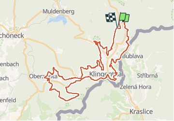
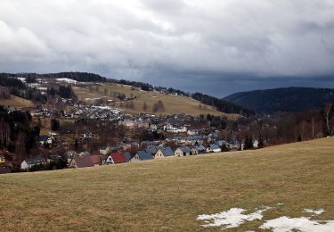
Trail On foot of 47 km to be discovered at Saxony, Vogtlandkreis, Klingenthal. This trail is proposed by SityTrail - itinéraires balisés pédestres.
Description
Juni 2013: im Abschnitt Klingenthal, ca. Kammweg 9, ist grüner Strich auf weißem Grund entlang des Grenzpfades ausgeschildert. Im gegensatz dazu befindet such an der Schutzhütte N50 22 29.7 E12 29 18.8 aber auch ein solches Wanderzeichen.
Symbol: grüner Strich, weißem Grund
Positioning
Comments
Trails nearby
![Trail On foot Kraslice - [Z] Hraničná (CZ/D) - Kraslice - Photo](https://media.geolcdn.com/t/375/260/9a2c3207-a793-4795-9d2f-4ccb6b0dd654.jpeg&format=jpg&maxdim=2)
![On foot On foot](https://static1.geolcdn.com/sitytour/trail-icons/100.png)
On foot
![](/images/other/stat-length.png)
![](https://static1.geolcdn.com/siteimages/upload/files/16400158638029165_repeat_loop_refresh_sync_direction_icon.png)
![Trail On foot Muldenhammer - Waldgebiet-Rundweg - Photo](https://media.geolcdn.com/t/375/260/9ecd7729-0093-40c0-8312-cefc7ab9e7fd.jpeg&format=jpg&maxdim=2)
![On foot On foot](https://static1.geolcdn.com/sitytour/trail-icons/100.png)
On foot
![](/images/other/stat-length.png)
![](https://static1.geolcdn.com/siteimages/upload/files/16400158638029165_repeat_loop_refresh_sync_direction_icon.png)
![Trail On foot Muldenhammer - Pyratalweg - Photo](https://media.geolcdn.com/t/375/260/d3568337-9dbb-4823-8481-c776dcae81f4.jpeg&format=jpg&maxdim=2)
![On foot On foot](https://static1.geolcdn.com/sitytour/trail-icons/100.png)
On foot
![](/images/other/stat-length.png)
![](https://static1.geolcdn.com/siteimages/upload/files/16400158638029165_repeat_loop_refresh_sync_direction_icon.png)
![Trail On foot Klingenthal - gelbe Markierung - Photo](https://media.geolcdn.com/t/375/260/441bebc5-6103-43f1-8d92-3850cf14ea71.jpeg&format=jpg&maxdim=2)
![On foot On foot](https://static1.geolcdn.com/sitytour/trail-icons/100.png)
On foot
![](/images/other/stat-length.png)
![](https://static1.geolcdn.com/siteimages/upload/files/16400158638029165_repeat_loop_refresh_sync_direction_icon.png)
![Trail On foot Bublava - [NS] Stopami horníků - Photo](https://media.geolcdn.com/t/375/260/257fa595-2ef7-4f16-a7bf-1d9572e0230e.jpeg&format=jpg&maxdim=2)
![On foot On foot](https://static1.geolcdn.com/sitytour/trail-icons/100.png)
On foot
![](/images/other/stat-length.png)
![](https://static1.geolcdn.com/siteimages/upload/files/16400158638029165_repeat_loop_refresh_sync_direction_icon.png)
![Trail On foot Muldenhammer - Ww Morgenröthe - Drei Bächel - Photo](https://media.geolcdn.com/t/375/260/ext.jpg?maxdim=2&url=https%3A%2F%2Fstatic1.geolcdn.com%2Fsiteimages%2Fupload%2Ffiles%2F1545311037marcheuse_200dpi.jpg)
![On foot On foot](https://static1.geolcdn.com/sitytour/trail-icons/100.png)
On foot
![](/images/other/stat-length.png)
![](https://static1.geolcdn.com/siteimages/upload/files/16400158638029165_repeat_loop_refresh_sync_direction_icon.png)
![Trail On foot Klingenthal - gelbe Markierung - Photo](https://media.geolcdn.com/t/375/260/ext.jpg?maxdim=2&url=https%3A%2F%2Fstatic1.geolcdn.com%2Fsiteimages%2Fupload%2Ffiles%2F1545311037marcheuse_200dpi.jpg)
![On foot On foot](https://static1.geolcdn.com/sitytour/trail-icons/100.png)
On foot
![](/images/other/stat-length.png)
![](https://static1.geolcdn.com/siteimages/upload/files/16400158638029165_repeat_loop_refresh_sync_direction_icon.png)