


4.1 km | 5.5 km-effort
![Trail On foot Měchenice - [M] Měchenice - Všenory - Photo](https://media.geolcdn.com/t/1900/400/06630537-e029-451b-a301-b274a78a918c.jpeg&format=pjpeg&maxdim=2)

Tous les sentiers balisés d’Europe GUIDE+


FREE GPS app for hiking
 SityTrail
IGN / Geographical institutes
SityTrail World
The world is yours!
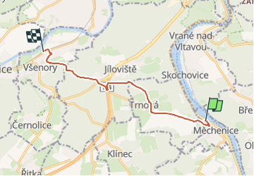
Trail On foot of 8.2 km to be discovered at Central Bohemia, Unknown, Měchenice. This trail is proposed by SityTrail - itinéraires balisés pédestres.
Trail created by cz:KČT.
měchenice;trnová;jílovišťská myslivna;všenory
![Trail On foot Měchenice - [M] Měchenice - Všenory - Photo 1](https://media.geolcdn.com/t/2048/auto/a349fbf0-3bb6-44ff-8804-90a6a6d5487e.jpeg&format=jpg&maxdim=0 "Trail On foot Měchenice - [M] Měchenice - Všenory - Photo 1")
![Trail On foot Měchenice - [M] Měchenice - Všenory - Photo 2](https://media.geolcdn.com/t/2048/auto/e10de89e-647e-4898-9f31-9e5eb1e780b4.jpeg&format=jpg&maxdim=0 "Trail On foot Měchenice - [M] Měchenice - Všenory - Photo 2")
![Trail On foot Měchenice - [M] Měchenice - Všenory - Photo 3](https://media.geolcdn.com/t/2048/auto/bab386e0-250d-4a12-ac53-6c85800a5d0b.jpeg&format=jpg&maxdim=0 "Trail On foot Měchenice - [M] Měchenice - Všenory - Photo 3")
![Trail On foot Měchenice - [M] Měchenice - Všenory - Photo 4](https://media.geolcdn.com/t/2048/auto/13f3ada1-3555-4cc5-902a-382d4147f157.jpeg&format=jpg&maxdim=0 "Trail On foot Měchenice - [M] Měchenice - Všenory - Photo 4")
![Trail On foot Měchenice - [M] Měchenice - Všenory - Photo 5](https://media.geolcdn.com/t/2048/auto/0217bd4e-cdc8-47ec-97f1-a611315c2b56.jpeg&format=jpg&maxdim=0 "Trail On foot Měchenice - [M] Měchenice - Všenory - Photo 5")
![Trail On foot Měchenice - [M] Měchenice - Všenory - Photo 6](https://media.geolcdn.com/t/2048/auto/fc898158-1387-4a21-acb5-45cd482f5a09.jpeg&format=jpg&maxdim=0 "Trail On foot Měchenice - [M] Měchenice - Všenory - Photo 6")
![Trail On foot Měchenice - [M] Měchenice - Všenory - Photo 7](https://media.geolcdn.com/t/2048/auto/b8ff51f6-3940-45d1-9006-30ae4b58afe6.jpeg&format=jpg&maxdim=0 "Trail On foot Měchenice - [M] Měchenice - Všenory - Photo 7")
![Trail On foot Měchenice - [M] Měchenice - Všenory - Photo 8](https://media.geolcdn.com/t/2048/auto/52cf6ca7-7013-4db5-b083-5e9507e1636a.jpeg&format=jpg&maxdim=0 "Trail On foot Měchenice - [M] Měchenice - Všenory - Photo 8")
![Trail On foot Měchenice - [M] Měchenice - Všenory - Photo 9](https://media.geolcdn.com/t/2048/auto/5573bfc3-a466-4662-8922-ca33e3b1f3e1.jpeg&format=jpg&maxdim=0 "Trail On foot Měchenice - [M] Měchenice - Všenory - Photo 9")
![Trail On foot Měchenice - [M] Měchenice - Všenory - Photo 10](https://media.geolcdn.com/t/2048/auto/06630537-e029-451b-a301-b274a78a918c.jpeg&format=jpg&maxdim=0 "Trail On foot Měchenice - [M] Měchenice - Všenory - Photo 10")
![Trail On foot Jíloviště - [Z] Jíloviště - Všenory - Photo](https://media.geolcdn.com/t/375/260/06630537-e029-451b-a301-b274a78a918c.jpeg&format=jpg&maxdim=2)
On foot
On foot
![Trail On foot Jíloviště - [Ž] Jíloviště - Černošice - Photo](https://media.geolcdn.com/t/375/260/658263c1-3fcf-44eb-9c17-2cb3a74b2689.jpeg&format=jpg&maxdim=2)
On foot
![Trail On foot Březová-Oleško - [Ž] Na Dolech-Psáry - Photo](https://media.geolcdn.com/t/375/260/5eaa306a-6bcd-49ff-9f66-a7c38f811023.jpeg&format=jpg&maxdim=2)
On foot
![Trail On foot Zvole - [Ž] Vrané - Ohrobská - Photo](https://media.geolcdn.com/t/375/260/2b998145-2f51-4216-98cc-0d1c0929ad72.jpeg&format=jpg&maxdim=2)
On foot
![Trail On foot Davle - [Ž] Davle - Jílové u P. - Photo](https://media.geolcdn.com/t/375/260/565e6ba4-c226-4a61-be53-789e63a62320.jpeg&format=jpg&maxdim=2)
On foot
![Trail On foot Čisovice - [Z] Bojov-Davle - Photo](https://media.geolcdn.com/t/375/260/0a1d902c-ad6e-40f3-ac52-7211c51fb088.jpeg&format=jpg&maxdim=2)
On foot

Motorboat