


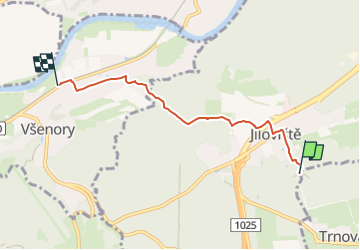

8.2 km | 11.1 km-effort
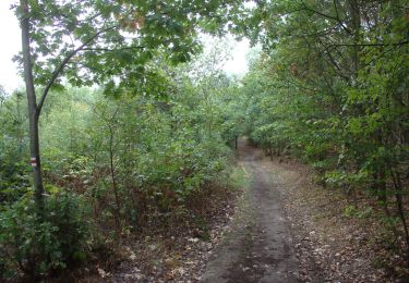
![Trail On foot Jíloviště - [Z] Jíloviště - Všenory - Photo](https://media.geolcdn.com/t/1900/400/06630537-e029-451b-a301-b274a78a918c.jpeg&format=pjpeg&maxdim=2)

Tous les sentiers balisés d’Europe GUIDE+


FREE GPS app for hiking
 SityTrail
IGN / Geographical institutes
SityTrail World
The world is yours!
Trail On foot of 4.1 km to be discovered at Central Bohemia, Unknown, Jíloviště. This trail is proposed by SityTrail - itinéraires balisés pédestres.
Trail created by cz:KČT.
jíloviště;všenory
![Trail On foot Jíloviště - [Z] Jíloviště - Všenory - Photo 1](https://media.geolcdn.com/t/2048/auto/c47df90d-6c25-4637-8a6e-488e5b0b6a43.jpeg&format=jpg&maxdim=0 "Trail On foot Jíloviště - [Z] Jíloviště - Všenory - Photo 1")
![Trail On foot Jíloviště - [Z] Jíloviště - Všenory - Photo 2](https://media.geolcdn.com/t/2048/auto/2be8d175-246a-4e63-a207-8c60d8b9e5e0.jpeg&format=jpg&maxdim=0 "Trail On foot Jíloviště - [Z] Jíloviště - Všenory - Photo 2")
![Trail On foot Jíloviště - [Z] Jíloviště - Všenory - Photo 3](https://media.geolcdn.com/t/2048/auto/20e471e1-4ac4-4903-8647-d4fab12c3efc.jpeg&format=jpg&maxdim=0 "Trail On foot Jíloviště - [Z] Jíloviště - Všenory - Photo 3")
![Trail On foot Jíloviště - [Z] Jíloviště - Všenory - Photo 4](https://media.geolcdn.com/t/2048/auto/a3b5464e-bd2a-4938-8663-bdba8a6a10df.jpeg&format=jpg&maxdim=0 "Trail On foot Jíloviště - [Z] Jíloviště - Všenory - Photo 4")
![Trail On foot Jíloviště - [Z] Jíloviště - Všenory - Photo 5](https://media.geolcdn.com/t/2048/auto/ec7c3087-fe62-4465-99b2-1e06c0e31175.jpeg&format=jpg&maxdim=0 "Trail On foot Jíloviště - [Z] Jíloviště - Všenory - Photo 5")
![Trail On foot Jíloviště - [Z] Jíloviště - Všenory - Photo 6](https://media.geolcdn.com/t/2048/auto/e491b4e9-5ad7-4702-8226-6095613e2ea9.jpeg&format=jpg&maxdim=0 "Trail On foot Jíloviště - [Z] Jíloviště - Všenory - Photo 6")
![Trail On foot Jíloviště - [Z] Jíloviště - Všenory - Photo 7](https://media.geolcdn.com/t/2048/auto/bab386e0-250d-4a12-ac53-6c85800a5d0b.jpeg&format=jpg&maxdim=0 "Trail On foot Jíloviště - [Z] Jíloviště - Všenory - Photo 7")
![Trail On foot Jíloviště - [Z] Jíloviště - Všenory - Photo 8](https://media.geolcdn.com/t/2048/auto/b8ff51f6-3940-45d1-9006-30ae4b58afe6.jpeg&format=jpg&maxdim=0 "Trail On foot Jíloviště - [Z] Jíloviště - Všenory - Photo 8")
![Trail On foot Jíloviště - [Z] Jíloviště - Všenory - Photo 9](https://media.geolcdn.com/t/2048/auto/c7cd93ac-764c-459e-84fb-70cc886c119c.jpeg&format=jpg&maxdim=0 "Trail On foot Jíloviště - [Z] Jíloviště - Všenory - Photo 9")
![Trail On foot Jíloviště - [Z] Jíloviště - Všenory - Photo 10](https://media.geolcdn.com/t/2048/auto/06630537-e029-451b-a301-b274a78a918c.jpeg&format=jpg&maxdim=0 "Trail On foot Jíloviště - [Z] Jíloviště - Všenory - Photo 10")
![Trail On foot Měchenice - [M] Měchenice - Všenory - Photo](https://media.geolcdn.com/t/375/260/06630537-e029-451b-a301-b274a78a918c.jpeg&format=jpg&maxdim=2)
On foot
On foot
![Trail On foot Jíloviště - [Ž] Jíloviště - Černošice - Photo](https://media.geolcdn.com/t/375/260/658263c1-3fcf-44eb-9c17-2cb3a74b2689.jpeg&format=jpg&maxdim=2)
On foot
On foot
![Trail On foot Zvole - [Ž] Vrané - Ohrobská - Photo](https://media.geolcdn.com/t/375/260/2b998145-2f51-4216-98cc-0d1c0929ad72.jpeg&format=jpg&maxdim=2)
On foot
![Trail On foot Davle - [Ž] Davle - Jílové u P. - Photo](https://media.geolcdn.com/t/375/260/565e6ba4-c226-4a61-be53-789e63a62320.jpeg&format=jpg&maxdim=2)
On foot
![Trail On foot Čisovice - [Z] Bojov-Davle - Photo](https://media.geolcdn.com/t/375/260/0a1d902c-ad6e-40f3-ac52-7211c51fb088.jpeg&format=jpg&maxdim=2)
On foot
![Trail On foot Černošice - [M] Černošice - Dub sedmi bratří - Photo](https://media.geolcdn.com/t/375/260/b3245b35-2206-4973-a671-0f64caf56378.jpeg&format=jpg&maxdim=2)
On foot