


13.3 km | 18.4 km-effort
![Trail On foot Domažlice - [Ž]Baldovské návrší - Hrádek - Photo](https://media.geolcdn.com/t/1900/400/4477f887-f79e-4587-bad2-e6810befb070.jpeg&format=pjpeg&maxdim=2)

Tous les sentiers balisés d’Europe GUIDE+


FREE GPS app for hiking
 SityTrail
IGN / Geographical institutes
SityTrail World
The world is yours!
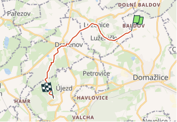
Trail On foot of 7.9 km to be discovered at Southwest, Plzeňský kraj, Domažlice. This trail is proposed by SityTrail - itinéraires balisés pédestres.
Trail created by cz:KČT.
![Trail On foot Domažlice - [Ž]Baldovské návrší - Hrádek - Photo 1](https://media.geolcdn.com/t/2048/auto/8312edc5-57af-42fe-9203-bc192677a7a9.jpeg&format=jpg&maxdim=0 "Trail On foot Domažlice - [Ž]Baldovské návrší - Hrádek - Photo 1")
![Trail On foot Domažlice - [Ž]Baldovské návrší - Hrádek - Photo 2](https://media.geolcdn.com/t/2048/auto/a775038b-cd6f-463f-a9a2-43b8beb39767.jpeg&format=jpg&maxdim=0 "Trail On foot Domažlice - [Ž]Baldovské návrší - Hrádek - Photo 2")
![Trail On foot Domažlice - [Ž]Baldovské návrší - Hrádek - Photo 3](https://media.geolcdn.com/t/2048/auto/3297ac25-49e2-4937-8116-f4ca9e9d5091.jpeg&format=jpg&maxdim=0 "Trail On foot Domažlice - [Ž]Baldovské návrší - Hrádek - Photo 3")
![Trail On foot Domažlice - [Ž]Baldovské návrší - Hrádek - Photo 4](https://media.geolcdn.com/t/2048/auto/651a53e1-0b64-4d7c-bb43-6e47cff57703.jpeg&format=jpg&maxdim=0 "Trail On foot Domažlice - [Ž]Baldovské návrší - Hrádek - Photo 4")
![Trail On foot Domažlice - [Ž]Baldovské návrší - Hrádek - Photo 5](https://media.geolcdn.com/t/2048/auto/d5e404c9-2376-4f1a-b9cd-c7601b65b6e8.jpeg&format=jpg&maxdim=0 "Trail On foot Domažlice - [Ž]Baldovské návrší - Hrádek - Photo 5")
![Trail On foot Domažlice - [Ž]Baldovské návrší - Hrádek - Photo 6](https://media.geolcdn.com/t/2048/auto/58ff5277-af20-4e09-b8fb-49e3a3020d0b.jpeg&format=jpg&maxdim=0 "Trail On foot Domažlice - [Ž]Baldovské návrší - Hrádek - Photo 6")
![Trail On foot Domažlice - [Ž]Baldovské návrší - Hrádek - Photo 7](https://media.geolcdn.com/t/2048/auto/f5318e8e-e95a-4129-ad4e-295bc3ae23b6.jpeg&format=jpg&maxdim=0 "Trail On foot Domažlice - [Ž]Baldovské návrší - Hrádek - Photo 7")
![Trail On foot Domažlice - [Ž]Baldovské návrší - Hrádek - Photo 8](https://media.geolcdn.com/t/2048/auto/4643e694-7522-41e5-949d-308db8fc41bf.jpeg&format=jpg&maxdim=0 "Trail On foot Domažlice - [Ž]Baldovské návrší - Hrádek - Photo 8")
![Trail On foot Domažlice - [Ž]Baldovské návrší - Hrádek - Photo 9](https://media.geolcdn.com/t/2048/auto/9cf46886-c7fe-4d42-8832-498e73abc013.jpeg&format=jpg&maxdim=0 "Trail On foot Domažlice - [Ž]Baldovské návrší - Hrádek - Photo 9")
![Trail On foot Domažlice - [Ž]Baldovské návrší - Hrádek - Photo 10](https://media.geolcdn.com/t/2048/auto/4477f887-f79e-4587-bad2-e6810befb070.jpeg&format=jpg&maxdim=0 "Trail On foot Domažlice - [Ž]Baldovské návrší - Hrádek - Photo 10")
![Trail On foot Domažlice - [Z] Domažlice - Spálenec - Photo](https://media.geolcdn.com/t/375/260/b2328041-b82d-4ca4-8f9f-5980374d1e88.jpeg&format=jpg&maxdim=2)
On foot
![Trail On foot Draženov - [M] Dobrá Voda - Pod Sádkem - Photo](https://media.geolcdn.com/t/375/260/0900bfa3-755c-44b1-8b19-f9a901462fa5.jpeg&format=jpg&maxdim=2)
On foot