


7.9 km | 10.6 km-effort
![Trail On foot Domažlice - [Z] Domažlice - Spálenec - Photo](https://media.geolcdn.com/t/1900/400/b2328041-b82d-4ca4-8f9f-5980374d1e88.jpeg&format=pjpeg&maxdim=2)

Tous les sentiers balisés d’Europe GUIDE+


FREE GPS app for hiking
 SityTrail
IGN / Geographical institutes
SityTrail World
The world is yours!
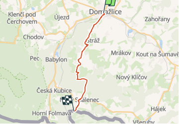
Trail On foot of 13.3 km to be discovered at Southwest, Plzeňský kraj, Domažlice. This trail is proposed by SityTrail - itinéraires balisés pédestres.
Trail created by cz:KČT.
![Trail On foot Domažlice - [Z] Domažlice - Spálenec - Photo 1](https://media.geolcdn.com/t/2048/auto/2290f72e-fe89-400c-b2ea-010b61404260.jpeg&format=jpg&maxdim=0 "Trail On foot Domažlice - [Z] Domažlice - Spálenec - Photo 1")
![Trail On foot Domažlice - [Z] Domažlice - Spálenec - Photo 2](https://media.geolcdn.com/t/2048/auto/2e0380aa-327c-451b-8048-2b8147fd3b84.jpeg&format=jpg&maxdim=0 "Trail On foot Domažlice - [Z] Domažlice - Spálenec - Photo 2")
![Trail On foot Domažlice - [Z] Domažlice - Spálenec - Photo 3](https://media.geolcdn.com/t/2048/auto/256d23fc-b9e3-481d-ab2f-f94b708d2883.jpeg&format=jpg&maxdim=0 "Trail On foot Domažlice - [Z] Domažlice - Spálenec - Photo 3")
![Trail On foot Domažlice - [Z] Domažlice - Spálenec - Photo 4](https://media.geolcdn.com/t/2048/auto/7234b83c-9d43-44d9-a419-7bff4270c1f6.jpeg&format=jpg&maxdim=0 "Trail On foot Domažlice - [Z] Domažlice - Spálenec - Photo 4")
![Trail On foot Domažlice - [Z] Domažlice - Spálenec - Photo 5](https://media.geolcdn.com/t/2048/auto/5f16e0e1-e4bc-4b83-9777-a8838e28d650.jpeg&format=jpg&maxdim=0 "Trail On foot Domažlice - [Z] Domažlice - Spálenec - Photo 5")
![Trail On foot Domažlice - [Z] Domažlice - Spálenec - Photo 6](https://media.geolcdn.com/t/2048/auto/ec7f31c0-3f62-42c2-b48f-ea1c609dc9ef.jpeg&format=jpg&maxdim=0 "Trail On foot Domažlice - [Z] Domažlice - Spálenec - Photo 6")
![Trail On foot Domažlice - [Z] Domažlice - Spálenec - Photo 7](https://media.geolcdn.com/t/2048/auto/86b982d4-b7da-4ba6-b4cf-5088ee51c24c.jpeg&format=jpg&maxdim=0 "Trail On foot Domažlice - [Z] Domažlice - Spálenec - Photo 7")
![Trail On foot Domažlice - [Z] Domažlice - Spálenec - Photo 8](https://media.geolcdn.com/t/2048/auto/813e1501-25e7-475d-9260-e590ab896868.jpeg&format=jpg&maxdim=0 "Trail On foot Domažlice - [Z] Domažlice - Spálenec - Photo 8")
![Trail On foot Domažlice - [Z] Domažlice - Spálenec - Photo 9](https://media.geolcdn.com/t/2048/auto/f61600b4-1968-4c49-9789-27c2ca095657.jpeg&format=jpg&maxdim=0 "Trail On foot Domažlice - [Z] Domažlice - Spálenec - Photo 9")
![Trail On foot Domažlice - [Z] Domažlice - Spálenec - Photo 10](https://media.geolcdn.com/t/2048/auto/b2328041-b82d-4ca4-8f9f-5980374d1e88.jpeg&format=jpg&maxdim=0 "Trail On foot Domažlice - [Z] Domažlice - Spálenec - Photo 10")
![Trail On foot Domažlice - [Ž]Baldovské návrší - Hrádek - Photo](https://media.geolcdn.com/t/375/260/4477f887-f79e-4587-bad2-e6810befb070.jpeg&format=jpg&maxdim=2)
On foot
![Trail On foot Draženov - [M] Dobrá Voda - Pod Sádkem - Photo](https://media.geolcdn.com/t/375/260/0900bfa3-755c-44b1-8b19-f9a901462fa5.jpeg&format=jpg&maxdim=2)
On foot
![Trail On foot Babylon - [Z] Babylon - Čerchov - Photo](https://media.geolcdn.com/t/375/260/68283d04-a0ca-4931-acda-af8a3d219992.jpeg&format=jpg&maxdim=2)
On foot
![Trail On foot Babylon - [Č] Babylon - Dmout - Photo](https://media.geolcdn.com/t/375/260/a4efbef1-28a7-48c7-9d31-72ddae391351.jpeg&format=jpg&maxdim=2)
On foot