![](/images/other/stat-length.png)
![Trail On foot Sebnitz - Hinterhermsdorfer Rundweg - Photo](https://media.geolcdn.com/t/1900/400/1a8e8230-aa16-4757-be71-8e0ebbd9d9d6.jpeg&format=pjpeg&maxdim=2)
Hinterhermsdorfer Rundweg
SityTrail - itinéraires balisés pédestres
Tous les sentiers balisés d’Europe GUIDE+
![Length](/images/other/stat-length.png)
Length
10.6 km
![Max alt](https://static1.geolcdn.com/siteimages/upload/files/1508320355ic_sort_altitude_max_24dp.png)
Max alt
427 m
![Uphill gradient](https://static1.geolcdn.com/siteimages/upload/files/1508320355ic_sort_den_pos_24dp.png)
Uphill gradient
277 m
![Km-Effort](/images/other/stat-length.png)
Km-Effort
14.3 km
![Min alt](https://static1.geolcdn.com/siteimages/upload/files/1508320355ic_sort_altitude_min_24dp.png)
Min alt
292 m
![Downhill gradient](https://static1.geolcdn.com/siteimages/upload/files/1508320355ic_sort_den_neg_24dp.png)
Downhill gradient
283 m
![Boucle](https://static1.geolcdn.com/siteimages/upload/files/16400158638029165_repeat_loop_refresh_sync_direction_icon.png)
Boucle
Yes
Signpost
Creation date :
2025-02-06 20:20:23.661
Updated on :
2025-02-06 20:20:23.661
![On foot](https://static1.geolcdn.com/sitytour/trail-icons/100.png)
3h14
Difficulty : Easy
![Scan this QR Code to open this trail in the SityTrail application](https://capi.geolives.com/qq0zvz2zws4bq2lad0pu/sitytour/trails/4344026/qr.png?size=200)
FREE GPS app for hiking
About
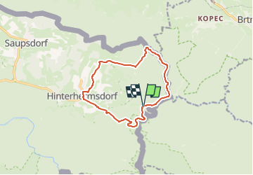
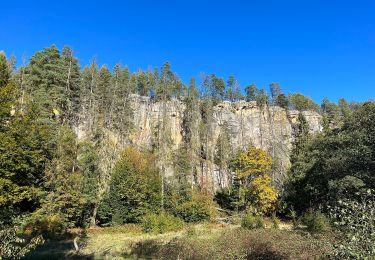
Trail On foot of 10.6 km to be discovered at Saxony, Sächsische Schweiz-Osterzgebirge, Sebnitz. This trail is proposed by SityTrail - itinéraires balisés pédestres.
Description
Symbol: Gelber Strich auf weißem Grund
Positioning
Country:
Germany
Region :
Saxony
Department/Province :
Sächsische Schweiz-Osterzgebirge
Municipality :
Sebnitz
Location:
Unknown
Start:(Dec)
Start:(UTM)
457060 ; 5641192 (33U) N.
Comments
Trails nearby
![Trail On foot Krásná Lípa - [M] Brtnický okruh - Photo](https://media.geolcdn.com/t/375/260/2c25ed32-bc80-4d66-bfb8-31499feb073b.jpeg&format=jpg&maxdim=2)
![On foot On foot](https://static1.geolcdn.com/sitytour/trail-icons/100.png)
[M] Brtnický okruh
On foot
Easy
Krásná Lípa,
Northwest,
Ústecký kraj,
Czech Republic
![](/images/other/stat-length.png)
6.6 km | 8.5 km-effort
1h 55min
![](https://static1.geolcdn.com/siteimages/upload/files/16400158638029165_repeat_loop_refresh_sync_direction_icon.png)
Yes
![Trail On foot Sebnitz - Grüner Punkt - Photo](https://media.geolcdn.com/t/375/260/9002a7e5-c65d-497b-8716-1fdae825f6a6.jpeg&format=jpg&maxdim=2)
![On foot On foot](https://static1.geolcdn.com/sitytour/trail-icons/100.png)
Grüner Punkt
On foot
Easy
Sebnitz,
Saxony,
Sächsische Schweiz-Osterzgebirge,
Germany
![](/images/other/stat-length.png)
14.5 km | 20 km-effort
4h 32min
![](https://static1.geolcdn.com/siteimages/upload/files/16400158638029165_repeat_loop_refresh_sync_direction_icon.png)
No
![Trail On foot Sebnitz - Grüner Strich, Sächsische Schweiz (rechtselbisch) - Photo](https://media.geolcdn.com/t/375/260/23ef35bf-8eaa-4189-9de0-061fcd1659b3.jpeg&format=jpg&maxdim=2)
![On foot On foot](https://static1.geolcdn.com/sitytour/trail-icons/100.png)
Grüner Strich, Sächsische Schweiz (rechtselbisch)
On foot
Medium
Sebnitz,
Saxony,
Sächsische Schweiz-Osterzgebirge,
Germany
![](/images/other/stat-length.png)
17.2 km | 24 km-effort
5h 25min
![](https://static1.geolcdn.com/siteimages/upload/files/16400158638029165_repeat_loop_refresh_sync_direction_icon.png)
No
![Trail On foot Sebnitz - Gelber Punkt, Panoramaweg Hinterhermsdorf - Photo](https://media.geolcdn.com/t/375/260/23ef35bf-8eaa-4189-9de0-061fcd1659b3.jpeg&format=jpg&maxdim=2)
![On foot On foot](https://static1.geolcdn.com/sitytour/trail-icons/100.png)
Gelber Punkt, Panoramaweg Hinterhermsdorf
On foot
Easy
Sebnitz,
Saxony,
Sächsische Schweiz-Osterzgebirge,
Germany
![](/images/other/stat-length.png)
8.2 km | 11.8 km-effort
2h 40min
![](https://static1.geolcdn.com/siteimages/upload/files/16400158638029165_repeat_loop_refresh_sync_direction_icon.png)
Yes
![Trail On foot Sebnitz - Blauer Strich, Sächsische Schweiz (rechtselbisch) - Photo](https://media.geolcdn.com/t/375/260/ff1b66c5-d65b-4aec-acb6-57c42b8ce4d1.jpeg&format=jpg&maxdim=2)
![On foot On foot](https://static1.geolcdn.com/sitytour/trail-icons/100.png)
Blauer Strich, Sächsische Schweiz (rechtselbisch)
On foot
Easy
Sebnitz,
Saxony,
Sächsische Schweiz-Osterzgebirge,
Germany
![](/images/other/stat-length.png)
13.4 km | 17.5 km-effort
3h 59min
![](https://static1.geolcdn.com/siteimages/upload/files/16400158638029165_repeat_loop_refresh_sync_direction_icon.png)
No
![Trail On foot Sebnitz - Paßgrund - Photo](https://media.geolcdn.com/t/375/260/edaa050f-ee46-4171-818b-1d5200b29cad.jpeg&format=jpg&maxdim=2)
![On foot On foot](https://static1.geolcdn.com/sitytour/trail-icons/100.png)
Paßgrund
On foot
Easy
Sebnitz,
Saxony,
Sächsische Schweiz-Osterzgebirge,
Germany
![](/images/other/stat-length.png)
3.4 km | 5.3 km-effort
1h 12min
![](https://static1.geolcdn.com/siteimages/upload/files/16400158638029165_repeat_loop_refresh_sync_direction_icon.png)
No
![Trail On foot Sebnitz - Dr.-Alfred-Meiche-Weg - Photo](https://media.geolcdn.com/t/375/260/ext.jpg?maxdim=2&url=https%3A%2F%2Fstatic1.geolcdn.com%2Fsiteimages%2Fupload%2Ffiles%2F1545311037marcheuse_200dpi.jpg)
![On foot On foot](https://static1.geolcdn.com/sitytour/trail-icons/100.png)
Dr.-Alfred-Meiche-Weg
On foot
Easy
Sebnitz,
Saxony,
Sächsische Schweiz-Osterzgebirge,
Germany
![](/images/other/stat-length.png)
13 km | 19.1 km-effort
4h 20min
![](https://static1.geolcdn.com/siteimages/upload/files/16400158638029165_repeat_loop_refresh_sync_direction_icon.png)
No
![Trail Walking Sebnitz - MALER 07 R - Photo](https://media.geolcdn.com/t/375/260/ext.jpg?maxdim=2&url=https%3A%2F%2Fstatic1.geolcdn.com%2Fsiteimages%2Fupload%2Ffiles%2F1553511878bg_sport_marche.png)
![Walking Walking](https://static1.geolcdn.com/sitytour/trail-icons/101.png)
MALER 07 R
Walking
Difficult
Sebnitz,
Saxony,
Sächsische Schweiz-Osterzgebirge,
Germany
![](/images/other/stat-length.png)
11.5 km | 18.3 km-effort
5h 30min
![](https://static1.geolcdn.com/siteimages/upload/files/16400158638029165_repeat_loop_refresh_sync_direction_icon.png)
No