Trail On foot Brno - [Z] Devět křížů - Obora - Photo

[Z] Devět křížů - Obora

Tous les sentiers balisés d’Europe GUIDE+

© OpenStreetMap contributors
Length
Length
22 km
Max alt
Max alt
524 m
Uphill gradient
Uphill gradient
499 m
Km-Effort
Km-Effort  
28 km
Min alt
Min alt
256 m
Downhill gradient
Downhill gradient
439 m
Boucle
Boucle
No
Signpost
Signpost
Creation date :
2025-02-06 20:16:03.037
Updated on :
2025-02-06 20:16:03.037

(0 Reviews)

On foot
On foot
6h28
Difficulty : Medium

Scan this QR Code to open this trail in the SityTrail application

FREE GPS app for hiking

Logo SityTrail SityTrail

IGN / Geographical institutes

Download SityTrail from the App Store Download SityTrail from Google Play

Logo SityTrail SityTrail World

The world is yours!

Download SityTrail from the App Store Download SityTrail from Google Play Download SityTrail on Huawei AppGallery

About

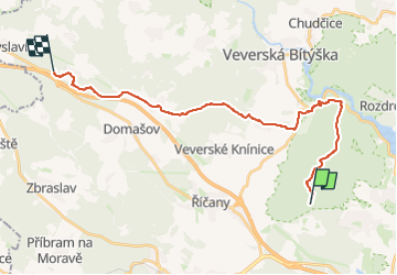
Trail On foot of 22 km to be discovered at Southeast, Jihomoravský kraj, Brno. This trail is proposed by SityTrail - itinéraires balisés pédestres.

Description

Trail created by cz:KČT.

Elevation profile

Positioning

Country:
Czech Republic
Region :
Southeast
Department/Province :
Jihomoravský kraj
Municipality :
Brno
Location:
Unknown
Start:(UTM)
606003 ; 5452342 (33U) N.

Trails nearby

Trail On foot Brno - NS Jelení žlíbek - Photo
On foot
GUIDE+

On foot

Easy
Brno, Southeast, Jihomoravský kraj, Czech Republic
3.3 km | 5.2 km-effort
1h 10min
No
Trail On foot Rozdrojovice - [M] Žebětín - Rozdrojovice - Photo
On foot
GUIDE+

On foot

Medium
Rozdrojovice, Southeast, Jihomoravský kraj, Czech Republic
15.2 km | 21 km-effort
4h 48min
No


Close
My subscriptions