


6.8 km | 8.4 km-effort
![Trail On foot Polná - [Z] Přibyslav - Polná - Photo](https://media.geolcdn.com/t/1900/400/075c8237-6652-4826-9aef-5f493afa6e41.jpeg&format=pjpeg&maxdim=2)

Tous les sentiers balisés d’Europe GUIDE+


FREE GPS app for hiking
 SityTrail
IGN / Geographical institutes
SityTrail World
The world is yours!
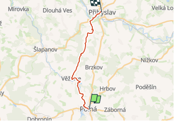
Trail On foot of 13.7 km to be discovered at Southeast, Kraj Vysočina, Polná. This trail is proposed by SityTrail - itinéraires balisés pédestres.
Trail created by cz:KČT.
![Trail On foot Polná - [Z] Přibyslav - Polná - Photo 1](https://media.geolcdn.com/t/2048/auto/5572e495-af38-41b3-a795-634a1a9cde26.jpeg&format=jpg&maxdim=0 "Trail On foot Polná - [Z] Přibyslav - Polná - Photo 1")
![Trail On foot Polná - [Z] Přibyslav - Polná - Photo 2](https://media.geolcdn.com/t/2048/auto/809e6583-3e53-44e4-94fe-3307f4cf2e91.jpeg&format=jpg&maxdim=0 "Trail On foot Polná - [Z] Přibyslav - Polná - Photo 2")
![Trail On foot Polná - [Z] Přibyslav - Polná - Photo 3](https://media.geolcdn.com/t/2048/auto/52270370-66cd-4832-b52c-794e9fb8219e.jpeg&format=jpg&maxdim=0 "Trail On foot Polná - [Z] Přibyslav - Polná - Photo 3")
![Trail On foot Polná - [Z] Přibyslav - Polná - Photo 4](https://media.geolcdn.com/t/2048/auto/97f16717-841e-4ddf-9487-4c8a5831ea9f.jpeg&format=jpg&maxdim=0 "Trail On foot Polná - [Z] Přibyslav - Polná - Photo 4")
![Trail On foot Polná - [Z] Přibyslav - Polná - Photo 5](https://media.geolcdn.com/t/2048/auto/6b65193f-52e1-40f3-bd03-d38c46e6da08.jpeg&format=jpg&maxdim=0 "Trail On foot Polná - [Z] Přibyslav - Polná - Photo 5")
![Trail On foot Polná - [Z] Přibyslav - Polná - Photo 6](https://media.geolcdn.com/t/2048/auto/b32f0b93-3462-4790-b703-55386daf97b9.jpeg&format=jpg&maxdim=0 "Trail On foot Polná - [Z] Přibyslav - Polná - Photo 6")
![Trail On foot Polná - [Z] Přibyslav - Polná - Photo 7](https://media.geolcdn.com/t/2048/auto/70010ec0-590f-4b4f-b996-59839f9e8f46.jpeg&format=jpg&maxdim=0 "Trail On foot Polná - [Z] Přibyslav - Polná - Photo 7")
![Trail On foot Polná - [Z] Přibyslav - Polná - Photo 8](https://media.geolcdn.com/t/2048/auto/79aac540-a8c2-44f3-b609-1f29b89cd613.jpeg&format=jpg&maxdim=0 "Trail On foot Polná - [Z] Přibyslav - Polná - Photo 8")
![Trail On foot Polná - [Z] Přibyslav - Polná - Photo 9](https://media.geolcdn.com/t/2048/auto/944190fd-f6eb-4064-9dfb-27b0144c59d3.jpeg&format=jpg&maxdim=0 "Trail On foot Polná - [Z] Přibyslav - Polná - Photo 9")
![Trail On foot Polná - [Z] Přibyslav - Polná - Photo 10](https://media.geolcdn.com/t/2048/auto/075c8237-6652-4826-9aef-5f493afa6e41.jpeg&format=jpg&maxdim=0 "Trail On foot Polná - [Z] Přibyslav - Polná - Photo 10")
![Trail On foot Polná - [Ž] Polná - Kukle, okruh - Photo](https://media.geolcdn.com/t/375/260/51187ab0-28db-4a00-97ca-cb3c00db34d7.jpeg&format=jpg&maxdim=2)
On foot
![Trail On foot Polná - [Z] Polná místní, okruh - Photo](https://media.geolcdn.com/t/375/260/a7a51ed6-d0d0-4931-bc45-033d0de4dc94.jpeg&format=jpg&maxdim=2)
On foot