


6 km | 7 km-effort
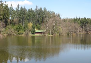
![Trail On foot Mukařov - [Ž] Sv.Donát - Mukařov - Photo](https://media.geolcdn.com/t/1900/400/bbc687d4-21c3-4dc3-b6bb-6878136b19e5.jpeg&format=pjpeg&maxdim=2)

Tous les sentiers balisés d’Europe GUIDE+


FREE GPS app for hiking
 SityTrail
IGN / Geographical institutes
SityTrail World
The world is yours!
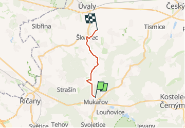
Trail On foot of 9.2 km to be discovered at Central Bohemia, Unknown, Mukařov. This trail is proposed by SityTrail - itinéraires balisés pédestres.
Trail created by cz:KČT.
![Trail On foot Mukařov - [Ž] Sv.Donát - Mukařov - Photo 1](https://media.geolcdn.com/t/2048/auto/440f53b4-8fae-4c8a-b603-2ad3a7c6404a.jpeg&format=jpg&maxdim=0 "Trail On foot Mukařov - [Ž] Sv.Donát - Mukařov - Photo 1")
![Trail On foot Mukařov - [Ž] Sv.Donát - Mukařov - Photo 2](https://media.geolcdn.com/t/2048/auto/45a0cce8-2ca5-4750-b104-4602a5d05f7d.jpeg&format=jpg&maxdim=0 "Trail On foot Mukařov - [Ž] Sv.Donát - Mukařov - Photo 2")
![Trail On foot Mukařov - [Ž] Sv.Donát - Mukařov - Photo 3](https://media.geolcdn.com/t/2048/auto/8d947e52-ac2a-4308-88b6-074a64569f75.jpeg&format=jpg&maxdim=0 "Trail On foot Mukařov - [Ž] Sv.Donát - Mukařov - Photo 3")
![Trail On foot Mukařov - [Ž] Sv.Donát - Mukařov - Photo 4](https://media.geolcdn.com/t/2048/auto/06b65ff2-c766-4fc0-865c-3e246135756b.jpeg&format=jpg&maxdim=0 "Trail On foot Mukařov - [Ž] Sv.Donát - Mukařov - Photo 4")
![Trail On foot Mukařov - [Ž] Sv.Donát - Mukařov - Photo 5](https://media.geolcdn.com/t/2048/auto/ab7daac3-dffd-427e-b893-81b59a78a71a.jpeg&format=jpg&maxdim=0 "Trail On foot Mukařov - [Ž] Sv.Donát - Mukařov - Photo 5")
![Trail On foot Mukařov - [Ž] Sv.Donát - Mukařov - Photo 6](https://media.geolcdn.com/t/2048/auto/eaf57d0b-3b03-4435-b0d0-a9e39f733aad.jpeg&format=jpg&maxdim=0 "Trail On foot Mukařov - [Ž] Sv.Donát - Mukařov - Photo 6")
![Trail On foot Mukařov - [Ž] Sv.Donát - Mukařov - Photo 7](https://media.geolcdn.com/t/2048/auto/dd8900c4-fb19-4d38-9fa3-74f4b3f9b545.jpeg&format=jpg&maxdim=0 "Trail On foot Mukařov - [Ž] Sv.Donát - Mukařov - Photo 7")
![Trail On foot Mukařov - [Ž] Sv.Donát - Mukařov - Photo 8](https://media.geolcdn.com/t/2048/auto/385175c4-ba96-4f69-b040-7532c352489e.jpeg&format=jpg&maxdim=0 "Trail On foot Mukařov - [Ž] Sv.Donát - Mukařov - Photo 8")
![Trail On foot Mukařov - [Ž] Sv.Donát - Mukařov - Photo 9](https://media.geolcdn.com/t/2048/auto/bbc687d4-21c3-4dc3-b6bb-6878136b19e5.jpeg&format=jpg&maxdim=0 "Trail On foot Mukařov - [Ž] Sv.Donát - Mukařov - Photo 9")
![Trail On foot Mukařov - [Ž] Sv.Donát - Mukařov - Photo 10](https://media.geolcdn.com/t/2048/auto/548c9c76-0bfc-4c9b-a59f-9b74f8b73a6e.jpeg&format=jpg&maxdim=0 "Trail On foot Mukařov - [Ž] Sv.Donát - Mukařov - Photo 10")
![Trail On foot Říčany - [Z] Říčany - Strašín - Photo](https://media.geolcdn.com/t/375/260/097096e4-f5aa-4357-9c89-5bc1327d8251.jpeg&format=jpg&maxdim=2)
On foot
On foot