Trail On foot Sezimovo Ústí - [M] Choustník - Sezimovo Ústí - Photo

[M] Choustník - Sezimovo Ústí

Tous les sentiers balisés d’Europe GUIDE+

© OpenStreetMap contributors
Length
Length
13.8 km
Max alt
Max alt
558 m
Uphill gradient
Uphill gradient
294 m
Km-Effort
Km-Effort  
17.2 km
Min alt
Min alt
408 m
Downhill gradient
Downhill gradient
153 m
Boucle
Boucle
No
Signpost
Signpost
Creation date :
2025-02-06 19:34:34.331
Updated on :
2025-02-06 19:34:34.331

(0 Reviews)

On foot
On foot
3h54
Difficulty : Easy

Scan this QR Code to open this trail in the SityTrail application

FREE GPS app for hiking

Logo SityTrail SityTrail

IGN / Geographical institutes

Download SityTrail from the App Store Download SityTrail from Google Play

Logo SityTrail SityTrail World

The world is yours!

Download SityTrail from the App Store Download SityTrail from Google Play Download SityTrail on Huawei AppGallery

About

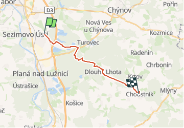
Trail On foot of 13.8 km to be discovered at Southwest, Jihočeský kraj, Sezimovo Ústí. This trail is proposed by SityTrail - itinéraires balisés pédestres.

Description

Trail created by cz:KČT.

Elevation profile

Positioning

Country:
Czech Republic
Region :
Southwest
Department/Province :
Jihočeský kraj
Municipality :
Sezimovo Ústí
Location:
Unknown
Start:(UTM)
478967 ; 5470321 (33U) N.

Trails nearby

Trail Other activity Tábor - tyh - Photo
Other activity
karawatsj

Other activity

Very easy
Tábor, Southwest, Jihočeský kraj, Czech Republic
70 km | 82 km-effort
5h 6min
No
Trail On foot Sezimovo Ústí - [M] Sezimovo Ústí - Planá nad Lužnicí - Photo
On foot
GUIDE+

On foot

Easy
Sezimovo Ústí, Southwest, Jihočeský kraj, Czech Republic
5.2 km | 6 km-effort
1h 21min
No
Trail On foot Planá nad Lužnicí - Okružní - Photo
On foot
GUIDE+

On foot

Easy
Planá nad Lužnicí, Southwest, Jihočeský kraj, Czech Republic
6.7 km | 8.3 km-effort
1h 53min
No


Close
My subscriptions