


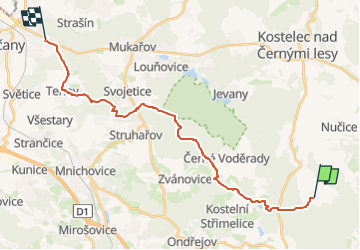

8.6 km | 10.5 km-effort
![Trail On foot Oplany - [Z] Říčany - Oplany - Photo](https://media.geolcdn.com/t/1900/400/3b1fcfde-8c92-4131-81a2-ceb1e5a41ff8.jpeg&format=pjpeg&maxdim=2)

Tous les sentiers balisés d’Europe GUIDE+


FREE GPS app for hiking
 SityTrail
IGN / Geographical institutes
SityTrail World
The world is yours!
Trail On foot of 21 km to be discovered at Central Bohemia, Unknown, Oplany. This trail is proposed by SityTrail - itinéraires balisés pédestres.
Trail created by cz:KČT.
V Ricanech zacina na stanici autobusu "Rychta"
![Trail On foot Oplany - [Z] Říčany - Oplany - Photo 1](https://media.geolcdn.com/t/2048/auto/11be5787-6716-42a3-858e-bcd50ed420b6.jpeg&format=jpg&maxdim=0 "Trail On foot Oplany - [Z] Říčany - Oplany - Photo 1")
![Trail On foot Oplany - [Z] Říčany - Oplany - Photo 2](https://media.geolcdn.com/t/2048/auto/d7536b72-1048-4f18-8eda-94d34308d297.jpeg&format=jpg&maxdim=0 "Trail On foot Oplany - [Z] Říčany - Oplany - Photo 2")
![Trail On foot Oplany - [Z] Říčany - Oplany - Photo 3](https://media.geolcdn.com/t/2048/auto/d2b377f9-41a6-4eee-b343-cf4be78df0fc.jpeg&format=jpg&maxdim=0 "Trail On foot Oplany - [Z] Říčany - Oplany - Photo 3")
![Trail On foot Oplany - [Z] Říčany - Oplany - Photo 4](https://media.geolcdn.com/t/2048/auto/289c5fc5-5088-4b6a-bdb2-26fdcc3a289c.jpeg&format=jpg&maxdim=0 "Trail On foot Oplany - [Z] Říčany - Oplany - Photo 4")
![Trail On foot Oplany - [Z] Říčany - Oplany - Photo 5](https://media.geolcdn.com/t/2048/auto/885b92f3-b089-4e15-a406-c60fe487f590.jpeg&format=jpg&maxdim=0 "Trail On foot Oplany - [Z] Říčany - Oplany - Photo 5")
![Trail On foot Oplany - [Z] Říčany - Oplany - Photo 6](https://media.geolcdn.com/t/2048/auto/81bfdb99-d5fd-4daf-81b8-89bb960991b6.jpeg&format=jpg&maxdim=0 "Trail On foot Oplany - [Z] Říčany - Oplany - Photo 6")
![Trail On foot Oplany - [Z] Říčany - Oplany - Photo 7](https://media.geolcdn.com/t/2048/auto/3d57319a-1fdc-4ca1-9eb2-95b3a212c8b7.jpeg&format=jpg&maxdim=0 "Trail On foot Oplany - [Z] Říčany - Oplany - Photo 7")
![Trail On foot Oplany - [Z] Říčany - Oplany - Photo 8](https://media.geolcdn.com/t/2048/auto/0fd7e0a6-cb45-47a5-ac52-de320cac0c53.jpeg&format=jpg&maxdim=0 "Trail On foot Oplany - [Z] Říčany - Oplany - Photo 8")
![Trail On foot Oplany - [Z] Říčany - Oplany - Photo 9](https://media.geolcdn.com/t/2048/auto/aa97db8c-42c4-4619-8eaf-c577ee50b529.jpeg&format=jpg&maxdim=0 "Trail On foot Oplany - [Z] Říčany - Oplany - Photo 9")
![Trail On foot Oplany - [Z] Říčany - Oplany - Photo 10](https://media.geolcdn.com/t/2048/auto/3b1fcfde-8c92-4131-81a2-ceb1e5a41ff8.jpeg&format=jpg&maxdim=0 "Trail On foot Oplany - [Z] Říčany - Oplany - Photo 10")
On foot
![Trail On foot Černé Voděrady - [Ž] Vyžlovský rybník - Černé Voděrady - Photo](https://media.geolcdn.com/t/375/260/81bfdb99-d5fd-4daf-81b8-89bb960991b6.jpeg&format=jpg&maxdim=2)
On foot